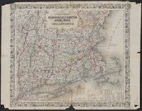
"Entered according to Act of Congress in the Year 1863 by J.H. Colton in the Clerks Office of the District Court for the Southern District of New York.", "Printed by D. Mc. Lellan, 26, and Includes tables for each state of population, farms, and manufacturing.
"Entered according to Act of Congress in the Year 1863 by J.H. Colton in the Clerks Office of the District Court for the Southern District of New York.", "Printed by D. Mc. Lellan, 26, and Includes tables for each state of population, farms, and manufacturing.
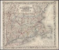
"Entered according to act of Congress, in the year 1853, by J.H. Colton, in the Clerks Office of the District Court of the United States for the Southern District of New York.", Prime meridians: Greenwich and Washington., Relief shown by hachures., and Shows state boundaries, major cities and towns, railroads, canals, military outposts, Indian tribal areas, "Indian Territory," the western territories of the United States, and Virginia as one state.
Publisher:
Published by J.H. Colton & Co., No. 172 William St.,
Subject (Geographic):
Indian Territory--Maps, Oklahoma --Maps, and United States--Maps