Skip to search
Skip to main content
Skip to first result
Search
You Searched For
Extent of Digitization
Completely digitized
Publication Place
New York :
New Search
Search Results
Creator:
Published / Created:
1841
Call Number:
BrSides 2019 100
Image Count:
1
Resource Type:
Maps, Atlases & Globes
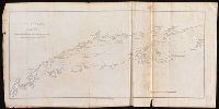
Description:
Coordinates not present on map and are approximated. and Depths shown by soundings.
Publisher:
Published by E. & G.W. Blunt,
Subject (Geographic):
Long Island Sound (N.Y. and Conn.)--Maps.
Subject (Name):
Blunt, Edmund M. (Edmund March), 1770-1862. American coast pilot. and Blunt, G. W. (George William), 1802-1878
Subject (Topic):
Tidal currents--Long Island Sound (N.Y. and Conn.)--Maps.
Found in:
Beinecke Rare Book and Manuscript Library > Long Island Sound : reduced from the large chart as surveyed by E. Blunt / engraved for Blunt's American coast pilot by W. Hooker.
Published / Created:
1912
Call Number:
773gmb 1912
Container / Volume:
BRBL_00497
Image Count:
2
Resource Type:
Maps, Atlases & Globes
Description:
Suburban New Jersey connections to New York on verso.
Publisher:
American Automobile Association ,
Subject (Geographic):
New Jersey--Maps
Found in:
Beinecke Rare Book and Manuscript Library > Main traveled routes through New Jersey.
Published / Created:
[1831?]
Call Number:
761 1831
Container / Volume:
BRBL_00447
Image Count:
1
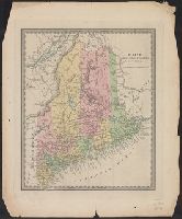
Resource Type:
Maps, Atlases & Globes
Publisher:
David H. Burr,
Subject (Geographic):
Maine--Maps
Found in:
Beinecke Rare Book and Manuscript Library > Maine.
Creator:
Published / Created:
1883
Call Number:
847gc Y12 1883
Container / Volume:
BRBL_00628
Image Count:
5
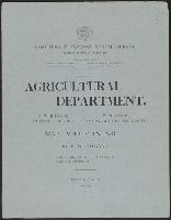
Resource Type:
Maps, Atlases & Globes
Alternative Title:
Preliminary agricultural map of Colville region, Washington Terr., Preliminary agricultural map of Yakima Region., and Soils of the Yakima and Colville regions.
Description:
Accompanied by text: Soils of the Yakima and Colville regions (1 leaf ; 61 cm.), Cover title., Preliminary agricultural map of Yakima Region -- Preliminary agricultural map of Colville region, Washington Terr., Raphael Pumpelly, director., and Relief shown by contours, spot heights, and hachures.
Publisher:
Julius Bien & Co.,
Subject (Name):
Hilgard, Eugene W. (Eugene Woldemar), 1833-1916, Julius Bien & Co, and Pumpelly, Raphael, 1837-1923
Subject (Topic):
Soils--Washington (State)--Maps
Found in:
Beinecke Rare Book and Manuscript Library > Map bulletin no. 1 / by E.W. Hilgard ; Northern Transcontinental Survey, Agricultural Department.
Published / Created:
[1843?]
Call Number:
755 1843A
Container / Volume:
BRBL_00441
Image Count:
1
Resource Type:
Maps, Atlases & Globes
Publisher:
David H. Burr,
Subject (Geographic):
Canada--Maps and East (U.S.)--Maps
Found in:
Beinecke Rare Book and Manuscript Library > Map exhibiting the country between Lakes Michigan and Erie and the contested boundary lines.
Published / Created:
1877
Call Number:
787hc 1864A
Container / Volume:
BRBL_00517A
Image Count:
1
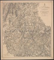
Resource Type:
Maps, Atlases & Globes
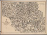
Description:
Map II. This map includes the region from Resaca on the north to Ackworth [sic] on the south and exhibits the works of the United States and Confederate forces (1864).
Publisher:
American Photo-Lithographic Co. ,
Subject (Geographic):
Georgia--Maps
Found in:
Beinecke Rare Book and Manuscript Library > Map illustrating the military operations of the Atlanta campaign. Map II. / compiled by authority of the Hon. the Secretary of War in the Office of the Chief of Engineers, U.S.A.
Published / Created:
1876
Call Number:
787hc 1864A
Container / Volume:
BRBL_00517A
Image Count:
1
Resource Type:
Maps, Atlases & Globes
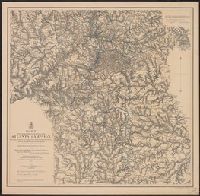
Description:
Map III. This map includes the region extending from Rome, Kingston, and Cassville on the north to include Dallas and Marietta on the south and exhibits the works of the United States and Confederate forces (1864)
Publisher:
American Photo-Lithographic Co. ,
Subject (Geographic):
Georgia--Maps
Found in:
Beinecke Rare Book and Manuscript Library > Map illustrating the military operations of the Atlanta campaign. Map III. / compiled by authority of the Hon. the Secretary of War in the Office of the Chief of Engineers, U.S.A.
Published / Created:
1874
Call Number:
787hc 1864A
Container / Volume:
BRBL_00517A
Image Count:
1
Resource Type:
Maps, Atlases & Globes
Description:
Map IV. Embracing the region from Pine, Lost, and Kennesaw Mountains south to include Atlanta and its environs, exhibiting the lines of operations at Pine, Lost, and Kennesaw Mts., at Smyrna Camp Ground a and Ms. notations in blue and red pencil.
Publisher:
American Photo-Lithographic Co. ,
Subject (Geographic):
Georgia--Maps
Found in:
Beinecke Rare Book and Manuscript Library > Map illustrating the military operations of the Atlanta campaign. Map IV. / compiled by authority of the Hon. the Secretary of War in the Office of the Chief of Engineers, U.S.A.
Published / Created:
1877
Call Number:
787hc 1864A
Container / Volume:
BRBL_00517A
Image Count:
1
Resource Type:
Maps, Atlases & Globes
Description:
Map V. This map includes the region from the Chattahoochee River south to Jonesboro and Lovejoy's Station and exhibits the works of the United States and Confederate forces (1877). and MS. notations in blue and red pencil.
Publisher:
American Photo-Lithographic Co. ,
Subject (Geographic):
Georgia--Maps
Found in:
Beinecke Rare Book and Manuscript Library > Map illustrating the military operations of the Atlanta campaign. Map V. / compiled by authority of the Hon. the Secretary of War in the Office of the Chief of Engineers, U.S.A.
Creator:
Published / Created:
1883
Call Number:
75bk 1883A
Container / Volume:
BRBL_00407A
Image Count:
1
Resource Type:
Maps, Atlases & Globes
Description:
Covers also parts of Canada and Mexico., Relief shown by hachures., and Shows proposed time zones by color for railroad lines.
Publisher:
American Bank Note Co.,
Subject (Name):
General Time Convention and Southern Railway Time Convention
Subject (Topic):
Railroads--Time standards--Canada--Maps, Railroads--Time standards--United States--Maps, and Time--Systems and standards--United States--Maps
Found in:
Beinecke Rare Book and Manuscript Library > Map illustrating the proposed system of standard time as reported to the General and Southern Railway Time conventions : at their meetings held on April 11th and 18th, 1883, and unanimously recommended by the conventions for adoption by the railway lines
Branch:v1.61.8 ,Deployed:2024-06-20T11:14:48-04:00