Skip to search
Skip to main content
Skip to first result
Search
You Searched For
Format
cartographic
Publication Place
New York :
New Search
Search Results
Published / Created:
1861
Call Number:
792cea P38 1861
Container / Volume:
BRBL_00519
Image Count:
1
Resource Type:
Maps, Atlases & Globes
Publisher:
W. Schaus,
Subject (Geographic):
Pensacola Bay (Fla.)--Maps
Found in:
Beinecke Rare Book and Manuscript Library > The Key of the South, showing Fort Pickens and vicinity, positions of forts, batteries, fleet & soundings of every part of Pensacola Bay/ By M.K. Couzens, Litho. Lang & Laing.
Published / Created:
[c1940?]
Call Number:
34 1940
Container / Volume:
BRBL_00091
Image Count:
1
Resource Type:
Maps, Atlases & Globes
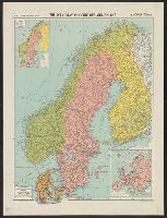
Description:
Insets: Minerals, Europe.
Publisher:
"Geographia" Map Co.,
Subject (Geographic):
Scandinavia--Maps
Found in:
Beinecke Rare Book and Manuscript Library > The Scandinavian Countries and Finland/ Alexander Gross F.R.G.S.
Published / Created:
1796
Call Number:
762 1796A
Container / Volume:
BRBL_00450
Image Count:
1
Resource Type:
Maps, Atlases & Globes
Description:
B. Tanner, Sculpt.
Publisher:
John Reid,
Found in:
Beinecke Rare Book and Manuscript Library > The State of New Hampshire, Compiled chiefly from Actual Surveys.
Published / Created:
1796
Call Number:
783 1796A
Container / Volume:
BRBL_00507
Image Count:
1
Resource Type:
Maps, Atlases & Globes
Description:
B. Tanner, sculpt. and From The American Atlas, New York, John Reid, 1796. Cf. Phillips, List of Maps of America, vol. 4, p. 985.
Publisher:
John Reid,
Subject (Geographic):
Virginia--Maps--Early works to 1800
Found in:
Beinecke Rare Book and Manuscript Library > The State of Virginia from the best Authorities.
Published / Created:
1795
Call Number:
777 1795A
Container / Volume:
BRBL_00503
Image Count:
1
Resource Type:
Maps, Atlases & Globes
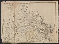
Description:
From The American Atlas, New York, John Reid, 1796. Cf. Phillips, Lists of maps of America, vol. 2 p. 395.
Publisher:
John Reid,
Subject (Geographic):
Maryland--Maps--Early works to 1800
Found in:
Beinecke Rare Book and Manuscript Library > The States of Maryland and Delaware from the latest Surveys.
Published / Created:
1837
Call Number:
811 1837
Container / Volume:
BRBL_00552
Image Count:
1
Resource Type:
Maps, Atlases & Globes
Description:
Engraved by S. Stiles & Co., New York. and Sections colored by hand.
Publisher:
J.H. Colton & Co.,
Subject (Geographic):
Michigan--Maps
Found in:
Beinecke Rare Book and Manuscript Library > The Surveyed Part of Michigan by John Farmer.
Published / Created:
c1901.
Call Number:
75 1901
Container / Volume:
BRBL_00407
Image Count:
1
Resource Type:
Maps, Atlases & Globes
Description:
"Rand, McNally & Co.'s New Business Atlas of the United States.", "Red figures show population according to census of 1900.", and Inset of Alaska.
Publisher:
The J.L. Mott Iron Works,
Subject (Geographic):
United States--Maps
Found in:
Beinecke Rare Book and Manuscript Library > The United States / by Rand, McNally & Co.
Published / Created:
1855
Call Number:
75 1855
Container / Volume:
BRBL_00401
Image Count:
1
Resource Type:
Maps, Atlases & Globes
Publisher:
Published by J.H. Colton & Co.,
Subject (Geographic):
United States--Maps
Found in:
Beinecke Rare Book and Manuscript Library > The United States of America.
Published / Created:
[1858?], c1855.
Call Number:
75 1858
Container / Volume:
BRBL_00401
Image Count:
1
Resource Type:
Maps, Atlases & Globes
Description:
"Entered according to Act of Congress, in the Year 1855..." and In top margin: no. 7, no. 8 -- from Colton's Atlas of the World?
Publisher:
Published by J.H. Colton & Co.,
Subject (Geographic):
United States--Maps
Found in:
Beinecke Rare Book and Manuscript Library > The United States of America.
Creator:
Published / Created:
1855
Call Number:
BrSides Folio 2017 60
Image Count:
1
Resource Type:
Maps, Atlases & Globes
Description:
"Entered according to act of Congress, in the year 1853, by J.H. Colton, in the Clerks Office of the District Court of the United States for the Southern District of New York.", Prime meridians: Greenwich and Washington., Relief shown by hachures., and Shows state boundaries, major cities and towns, railroads, canals, military outposts, Indian tribal areas, "Indian Territory," the western territories of the United States, and Virginia as one state.
Publisher:
Published by J.H. Colton & Co., No. 172 William St.,
Subject (Geographic):
Indian Territory--Maps, Oklahoma --Maps, and United States--Maps
Subject (Name):
Colton, J. H. (Joseph Hutchins), 1800-1893
Subject (Topic):
Indians of North America
Found in:
Beinecke Rare Book and Manuscript Library > The United States of America.
Branch:v1.61.8 ,Deployed:2024-06-20T11:14:46-04:00