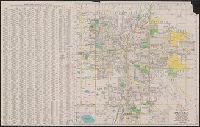
On verso: Local area maps showing locations of "Real Tour hotels": Albany, N.Y. -- Briarcliff Manor, N.Y. -- Greenfield, Mass. -- Hartford, Conn. -- New Haven, Conn. -- Pittsfield, Mass. -- Pough and On verso: Map of Berkshire County, Mass. and mileage table.
Publisher:
Automobile Club of America,
Subject (Geographic):
Berkshire Hills (Mass.)--Maps and New England--Maps
Subject (Topic):
Hotels--Massachusetts--Berkshire Hills--Maps, Hotels--New England--Maps, Roads--Massachusetts--Berkshire Hills--Maps, and Roads--New England--Maps
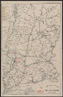
Birds eye view of Virginia, Maryland, Delaware and the District of Columbia
Description:
Bar scales shown in statute miles, nautical miles, and lieues communes de France., Imperfect: Mutilated., Inset: [Gulf of Mexico states] -- [Richmond area]., Relief shown by shading., and Shows railroads.
Publisher:
W. Schaus,
Subject (Geographic):
Delaware--Maps, Gulf States--Maps, Maryland--Maps, United States--History--Civil War, 1861-1865--Maps, and Virginia--Maps
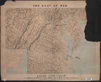
Includes population chart and index to ownership of electric railways., Inset: Map showing the lines of communication between New York, Boston and the West., and Relief shown by shading and spot heights.
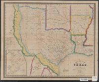
"Entered according to Act of Congress, in the Year 1845, by R.S. Fisher, in the Clerks Office of the District Court of the Southern District of New York.", Includes distances table., and Inset: Plan of the Port of Galveston / made by order of the Mexican govern
Publisher:
R.S. Fisher,
Subject (Geographic):
Galveston Bay (Tex.)--Maps, Texas--Administrative and political divisions--Maps, and Texas--Maps
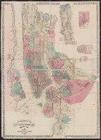
Topographical map of the cities of New York, Brooklyn, Jersey City and Hoboken
Description:
Hand colored., Insets: New York County north of 150th St. -- Map of New Neth, and Shows wards, other unspecified districts, ferry lines, some buildings and topographical details of surrounding islands, and parts of Queens County and New Jersey north of Hoboken.
Publisher:
M. Dripps,
Subject (Geographic):
Brooklyn (New York, N.Y.)--Administrative and political divisions--Maps, Brooklyn (New York, N.Y.)--Maps, Hoboken (N.J.)--Maps, Jersey City (N.J.)--, and New York (N.Y.)--Administrative and political divisions--Maps
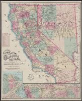
Map of the city of San Francisco, California., Map of the Great National Pacific Railroads., and Topographical railroad and county map of the states of California and Nevada
Description:
"Entered according to act of Congress A.D. 1868 by Frey & Nell in the clerks office of the district court of the United States for the southern district of New York." and Includes insets of "Map of the city of San Francisco, California" and "Map of the Great National Pacific Railroads," distance list, and difference of time chart.
Publisher:
A.C. Frey & Co. ; and General agents for California, A. Roman & Co.,
Subject (Geographic):
California--Maps, Nevada--Maps, and San Francisco (Calif.)--Maps
Subject (Name):
A. Roman & Co, A.C. Frey & Co, and Ferd. Mayer & Co
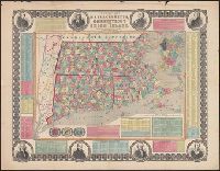
"Entered according to act of Congress in the year 1855 by Ensign, Bridgman & Fanning ..." and Border includes 8 portraits (John Hancock, Cotton Mather, Daniel Webster, Roger Williams, Gov. Trumbull, Timothy Dwight, O. Ellsworth, and Gen. Greene), 3 vignettes,
Publisher:
Ensign, Bridgman & Fanning,
Subject (Geographic):
Boston (Mass.)--Maps, Connecticut--Maps, Massachusetts--Maps, and Rhode Island--Maps
Subject (Topic):
Cities and towns--Connecticut--Maps, Cities and towns--Massachusetts--Maps, and Cities and towns--Rhode Island--Maps
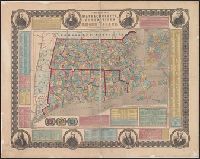
"Entered according to act of Congress in the year 1855 by Ensign, Bridgman & Fanning ...", Border includes 8 portraits (J, Hand colored by township. State and county borders outlined., Inset: "Boston.", and Prime meridian: Washington (top) and Greenwich (bottom).
Publisher:
Ensign, Bridgman & Fanning,
Subject (Geographic):
Boston (Mass.)--Maps, Connecticut--Maps, Massachusetts--Maps, and Rhode Island--Maps
Subject (Topic):
Cities and towns--Connecticut--Maps, Cities and towns--Massachusetts--Maps, and Cities and towns--Rhode Island--Maps