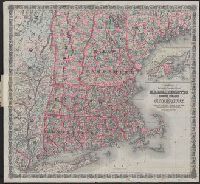
"Entered according to Act of Congress in the Year 1860 by J.H. Colton in the Clerks Office of the District Court for the Southern District of New York.", Inset: British Provinces. Scale [ca. 1:1,850,000]., Prime meridians: Greenwich and Washington, D.C., and Rel
Colton, G. Woolworth (George Woolworth), 1827-1901
Published / Created:
1866, c1860.
Call Number:
753 1866C
Container / Volume:
BRBL_00415
Image Count:
1
Resource Type:
Maps, Atlases & Globes
Alternative Title:
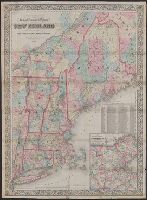
Railroad, township & distance map of New England and Railroad, township and distance map of New England
Description:
Area includes all of New England and parts of New York State, Quebec and New Brunswick., Entered according to act of Congress, in the year 1860, by G. Woolworth Colton in the clerk's office of the District Court of the Southern District of New York., and Relief