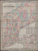
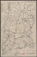
"Entered according to Act of Congress in the Year 1864 by A.J, From Johnson's new illustrated family atlas [New York : Johnson and Ward, 1866], plates 23-24., Includes legend., Meridians: Greenwich and Washington., and Shows railroads, counties, cities and towns.
Publisher:
Johnson and Ward,
Subject (Geographic):
New England--Maps
Subject (Name):
Johnson and Ward and Johnson, A. J. (Alvin Jewett), 1827-1884. Johnson's new illustrated family atlas
Colton, G. Woolworth (George Woolworth), 1827-1901
Published / Created:
1866, c1860.
Call Number:
753 1866C
Container / Volume:
BRBL_00415
Image Count:
1
Resource Type:
Maps, Atlases & Globes
Alternative Title:
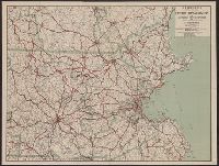
Railroad, township & distance map of New England and Railroad, township and distance map of New England
Description:
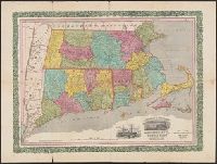
Area includes all of New England and parts of New York State, Quebec and New Brunswick., Entered according to act of Congress, in the year 1860, by G. Woolworth Colton in the clerk's office of the District Court of the Southern District of New York., and Relief
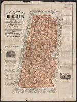
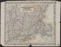
Borders of counties in red, yellow, green and blue; borders of Connecticut and Rhode Island in red., Cover title: Horace Thayer & Co.'s map of Mass., Conn. & R.I., In purplish black cloth covered folder with gold title within decorative border., and Includes vig
On verso: Local area maps showing locations of "Real Tour hotels": Albany, N.Y. -- Briarcliff Manor, N.Y. -- Greenfield, Mass. -- Hartford, Conn. -- New Haven, Conn. -- Pittsfield, Mass. -- Pough and On verso: Map of Berkshire County, Mass. and mileage table.
Publisher:
Automobile Club of America,
Subject (Geographic):
Berkshire Hills (Mass.)--Maps and New England--Maps
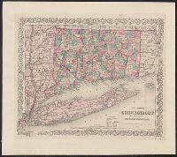
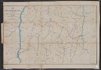
Covers areas of N.Y., Conn., and Mass. surrounding their intersection. and Includes ancillary "Profile of the Dutchess and Columbia and the proposed Connecticut Western Rail Road."
Publisher:
H.H. Lloyd & Co.'s Map Establishment,
Subject (Geographic):
Massachusetts--Maps
Subject (Name):
Connecticut Western Railroad Co.--Maps and Dutchess and Columbia Railroad Co.--Maps
"Entered according to Act of Congress in the Year 1863 by J.H. Colton in the Clerks Office of the District Court for the Southern District of New York.", "Printed by D. Mc. Lellan, 26, and Includes tables for each state of population, farms, and manufacturing.