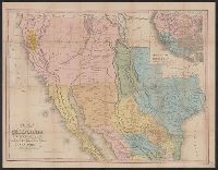
Tanner's travelling map of California &c, Travelling map of California, and United States, Mexico &c, showing the routes from N. York to St. Francisco by land & water.
Description:
Includes inset of "United States, Mexico &c, showing the routes from N. York to St. Francisco by land & water.", Library's copy 2 mounted on linen, without cover., Relief shown by hachures., Shows the New Southwest and parts of Texas and Mexico., and Text inside front cover, "Table of routes from New-York to California with the modes of conveyance, distances, time and fares."
Publisher:
H.S. Tanner,
Subject (Geographic):
California--Gold discoveries--Maps, California--Maps, Mexico--Maps, and Southwest, New--Maps
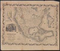
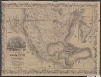
Includes 2 insets, ill., and distance table., Prime meridians: Greenwich and Washington., Relief shown by hachures and spot heights., Shows California's gold region and western trails., and Variant ed. in same year.
Publisher:
J.H. Colton,
Subject (Geographic):
California--Gold discoveries--Maps, North America--Maps, and United States--Maps
"Entered according to act of Congress in the year 1849 by J.H. Colton ....", "Printed at Ackermans r[ooms 120?] Fulton St. N.Y.", Includes 2 insets, ill., and distance table., Prime meridians: Greenwich and Washington., and Relief shown by hachures and spot heigh
Publisher:
J.H. Colton,
Subject (Geographic):
California--Gold discoveries--Maps, North America--Maps, and United States--Maps