Kipling, Rudyard, 1865-1936 Robinson, W. Heath (William Heath), 1872-1944
Published / Created:
1910
Call Number:
Ip K628 907cb
Image Count:
1
Resource Type:
Books, Journals & Pamphlets
Alternative Title:
Poems
Description:
Colored plates accompanied by guard sheets with descriptive letter-press., Depew Collection. "This edition is printed on a special hand made paper limited to one hundred and twenty-five copies signed by the author of which this is no. 18. [Signed:] Rudyard Kipling.", Illustrated t.p., and Includes indexes.
Publisher:
Doubleday, Page & Co.,
Subject (Name):
Depew Collection and Kipling, Rudyard,--1865-1936--Autograph
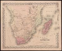
Colton, J. H. (Joseph Hutchins), 1800-1893, creator.
Published / Created:
[1855]
Call Number:
BrSides 2019 90
Image Count:
2
Resource Type:
Maps, Atlases & Globes
Description:
"Entered according to Act of Congress in the year 1855 by J.H. Colton & Co. in the Clerks Office of the District Court of the United States for the Southern District of New York.", "No. 36" in power right corner., From Colton's Atlas of the world., Prime meridian: Washington, D.C., Relief shown by hachures., and Text on verso with caption title "Cape of Good Hope--Cape Colony."
Publisher:
Published by J.H. Colton,
Subject (Geographic):
Africa, Southern--Maps.
Subject (Name):
Colton, G. Woolworth (George Woolworth), 1827-1901. Colton's atlas of the world.
"Entered according to act of Congress in the year 1855 by J.H. Colton in the clerks office of the district court for the southern district of New York.", "No. 52.", Includes inset of "City of San Francisco.", Relief shown by hachures and spot heights., and Text on verso: The territories of Oregon and Washington.
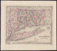
Includes key to symbols. and Includes Long Island and adjoining portions of Massachusetts, Rhode Island, and New York, including the Hudson River Valley northward to Malden.
Publisher:
G. W. and C. B. Colton,
Subject (Geographic):
Connecticut--Maps, Hudson River Valley--Maps, Long Island (N.Y.)--Maps, New York (State)--Maps, and Rhode Island--Maps
1 inch = ca. 10 miles., Advertisement for their maps, on front pastedown., Colored by town; borders of counties and of states in red., and In brown cloth covered folder, with "Colton's Map of Connecticut" and publisher's name in gold, surrounded by curvilinear d
Publisher:
G.W. and C.B. Colton,
Subject (Geographic):
Connecticut--Maps, Long Island (N.Y.)--Maps, and New York (State)--Maps
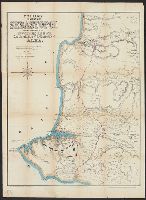
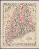
"Entered according to Act of Congress in the year 1884 by G.W. & C.B. Colton & Co. in the office of the Librarian of Congress at Washington.", From Maine state year-book and annual register, for the year 1884., and Shows county, town, and unincorporated townshi
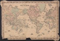
"Entered according to Act of Congress in the Year 1855 by J.H. Colton & Co. in the Clerks Office of the District Court of the United States for the Southern District of New York.", Inset: Vicinity of Boston. Scale [ca. 1:195,000]., and Prime meridians: Greenwic
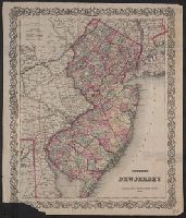
"Entered according to Act of Congress in the year 1855 ... for the Southern District of New York.", Hand colored by township; counties outlined in red. Map within decorative border., Indicates railroads, canals, and roads., and Prime meridians: Greenwich and Was
Publisher:
G.W. and C.B. Colton,
Subject (Geographic):
New Jersey and New Jersey--Maps.
Subject (Name):
Colton, G. Woolworth (George Woolworth), 1827-1901 and Colton, J. H. (Joseph Hutchins), 1800-1893