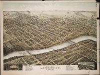
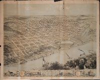
Print shows a bird's eye view of Lawrence, Kansas in 1880 numbered with 33 points of interest and indexed under the title "The New," to left of print's title caption; and, in the lower right, a map insert labeled, "Lawrence in 1855" numbered with 20 points of interest and indexed under the title "The Old," to right of the print's title caption
Description:
BEIN BrSides Zc39 880mo copy 1: Imperfect: lower right corner of sheet, upper right margin, and small section of right hand side broken off; a tear across sheet from right to center about one third up sheet. On sheet 62 x 82 cm., BEIN BrSides Zc39 880mo copy 2: On sheet 64 x 82 cm., Title from caption below image., Pictorial representation., and "Copyright by D.D. Morse, 1880."
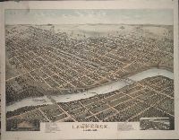
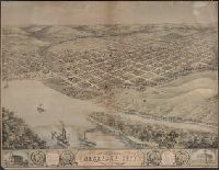
Print shows Council Bluffs, Iowa, in a bird's eye view, looking from the east bank of Mosquito Creek, across the tracks of the Chicago, Rock Island, and Pacific Railroad toward Lincoln Hill in the northwest
Description:
Title from caption below image. and Includes ill. and index to points of interest below image.
Publisher:
Merchants Lithographing Co.
Subject (Geographic):
Council Bluffs (Iowa) and Mosquito Creek (Iowa)
Subject (Name):
Chicago, Rock Island, and Pacific Railroad Company (1866-1880)
BEIN BrSides Zc37 868ru: Imperfect: 20 cm tear from top edge; On sheet 61 x 76 cm., Title from caption below image., and Includes ill. and index to points of interest.
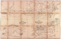
Map showing the relative position at Rock Island with the northwestern states and territories and its connections by rail roads and rivers
Description:
BEIN BrSides Elephant Folio 2017 14: Imperfect: brittle and chipped, with some loss of text., Relief shown by hachures., "Lith. by Ed Mendel, Chicago.", Coordinates not present on map and are approximated., and Includes two maps below: Map of Rock Island showing government property water power and Fort Armstrong; Map of Rock Island and vicinity with its coal fields.
Publisher:
publisher not identified
Subject (Geographic):
Illinois, Rock Island, United States, Rock Island., and United States.
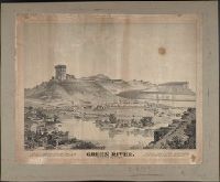
Deák gives a publication date of approximately 1869., "Green River City, located on the Green River, 846 miles west of Omaha.", and Available also through the Library of Congress Web site as a raster image.