Search
You Searched For
Search Results
- Creator:
- Tyrrell, Joseph Burr, 1858-1957
- Published / Created:
- c1897
- Call Number:
- 848 1897E
- Container / Volume:
- BRBL_00630
- Image Count:
- 1
- Resource Type:
- Maps, Atlases & Globes
- Found in:
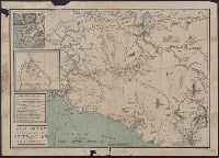
- Beinecke Rare Book and Manuscript Library > Gold region approaches by Copper River and the Dalton Trail / compiled from latest U.S. surveys, British authorities and other sources by J.B. Tyrrell.
- Published / Created:
- 1929
- Call Number:
- 848 C36 1929
- Container / Volume:
- BRBL_00632
- Image Count:
- 1
- Resource Type:
- Maps, Atlases & Globes
- Found in:
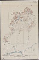
- Beinecke Rare Book and Manuscript Library > Topographic map of Chandalar-Sheenjek region, Alaska.
- Creator:
- National Geographic Society (U.S.). Map Dept
- Published / Created:
- c1922
- Call Number:
- 88cbf 1914
- Container / Volume:
- BRBL_00648
- Image Count:
- 1
- Resource Type:
- Maps, Atlases & Globes
- Found in:
- Beinecke Rare Book and Manuscript Library > The countries of the Caribbean : including Mexico, Central America, the West Indies, and the Panama Canal / prepared especially for the National geographic magazine.
- Creator:
- United States Coast Survey
- Published / Created:
- 1872
- Call Number:
- 764 F195 1872
- Container / Volume:
- BRBL_00457
- Image Count:
- 1
- Resource Type:
- Maps, Atlases & Globes
- Found in:
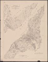
- Beinecke Rare Book and Manuscript Library > Narraganset Bay : Sheet No. 7.
- Creator:
- United States. Army Map Service
- Published / Created:
- 1947
- Call Number:
- 796 1947A
- Container / Volume:
- BRBL_00526
- Image Count:
- 1
- Resource Type:
- Maps, Atlases & Globes
- Found in:
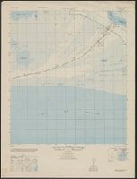
- Beinecke Rare Book and Manuscript Library > Sabine Pass, Tex., La. / prepared under the direction of the Chief of the Engineers by the Army Map Service (AM), U.S. Army.
- Creator:
- National Geographic Society (U.S.). Cartographic Section
- Published / Created:
- 1954
- Call Number:
- 844 1954
- Container / Volume:
- BRBL_00603
- Image Count:
- 1
- Resource Type:
- Maps, Atlases & Globes
- Found in:
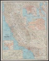
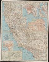
- Beinecke Rare Book and Manuscript Library > A map of California : with descriptive notes / compiled and drawn in the Cartographic Section of the National Geographic Society ; James M. Darley, chief cartographer.
- Creator:
- National Geographic Society (U.S.). Cartographic Section
- Published / Created:
- 1954
- Call Number:
- 844 1954
- Container / Volume:
- BRBL_00603
- Image Count:
- 1
- Resource Type:
- Maps, Atlases & Globes
- Found in:
- Beinecke Rare Book and Manuscript Library > A map of California : with descriptive notes / compiled and drawn in the Cartographic Section of the National Geographic Society ; James M. Darley, chief cartographer.
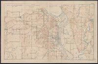
- Published / Created:
- [1909?]
- Call Number:
- 825 L487 1909A
- Container / Volume:
- BRBL_00574
- Image Count:
- 1
- Resource Type:
- Maps, Atlases & Globes
- Found in:
- Beinecke Rare Book and Manuscript Library > Map of Fort Leavenworth, Kansas and vicinity.
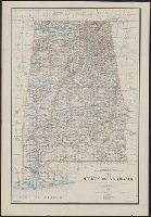
- Creator:
- King, Harry
- Published / Created:
- 1895
- Call Number:
- 793 1895
- Container / Volume:
- BRBL_00520
- Image Count:
- 1
- Resource Type:
- Maps, Atlases & Globes
- Found in:
- Beinecke Rare Book and Manuscript Library > Map of the state of Alabama : compiled from the official records of the General Land Office and other sources / under the direction of Harry King, C.E. Chief of Drafting Division G.L.O.; compiled by Rob[t] H. Morton; revised and drawn by Daniel O'Hare.
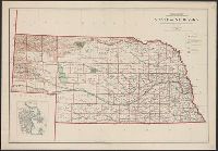
- Creator:
- United States. General Land Office
- Published / Created:
- 1908
- Call Number:
- 824 1908
- Container / Volume:
- BRBL_00570
- Image Count:
- 1
- Resource Type:
- Maps, Atlases & Globes
- Found in:
- Beinecke Rare Book and Manuscript Library > State of Nebraska / Department of the Interior, General Land Office ; compiled from the official records of the General Land Office and other sources under the direction of I.P. Berthrong ; compiled by A.F. Dinsmore ; traced and lettered by Wm. Bauman, Jr