Search
You Searched For
Search Results
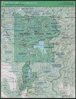
- Creator:
- National Geographic Society (U.S.). Cartographic Division
- Published / Created:
- c1989.
- Call Number:
- 833 Y38 1989
- Container / Volume:
- BRBL_00584
- Image Count:
- 2
- Resource Type:
- Maps, Atlases & Globes
- Found in:
- Beinecke Rare Book and Manuscript Library > Yellowstone and Grand Teton / produce by the Cartographic Division, National Geographic Society ; John B. Garver, Jr., chief cartographer.
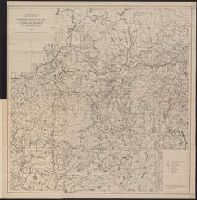
- Published / Created:
- 1917
- Call Number:
- 762gcr W588 1917
- Container / Volume:
- BRBL_00451
- Image Count:
- 2
- Resource Type:
- Maps, Atlases & Globes
- Found in:
- Beinecke Rare Book and Manuscript Library > White Mountain National Forest, New Hampshire and Maine / U.S. Department of Agriculture, Forest Service, Henry S. Graves, Forester.
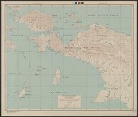
- Creator:
- United States. Army Map Service
- Published / Created:
- [19]44.
- Call Number:
- 269gmb 1945B
- Container / Volume:
- BRBL_00023A
- Image Count:
- 1
- Resource Type:
- Maps, Atlases & Globes
- Found in:
- Beinecke Rare Book and Manuscript Library > Western New Guinea : special strategic map / compiled by the Army Map Service.
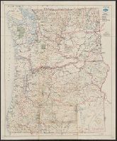
- Creator:
- Westgard, A. L. (Anthon L.), b. 1865
- Published / Created:
- c1920.
- Call Number:
- 847gmb 1920A
- Container / Volume:
- BRBL_00629
- Image Count:
- 2
- Resource Type:
- Maps, Atlases & Globes
- Found in:
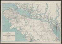
- Beinecke Rare Book and Manuscript Library > Washington and Oregon / prepared and issued by Touring Information Board, American Automobile Association ; prepared by A.L. Westgard, field representative, American Automobile Association ; F.S.R. jr.
- Creator:
- United States. Army. Signal Corps
- Published / Created:
- 1872
- Call Number:
- 75CF 1872
- Container / Volume:
- BRBL_00409
- Image Count:
- 1
- Resource Type:
- Maps, Atlases & Globes
- Found in:
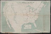
- Beinecke Rare Book and Manuscript Library > War Department weather map / published by authority of the Secretary of War.
- Creator:
- Great Britain. Inter-service Topographical Dept
- Published / Created:
- 1943
- Call Number:
- 40 V715 1943
- Image Count:
- 1
- Resource Type:
- Maps, Atlases & Globes
- Found in:
- Beinecke Rare Book and Manuscript Library > Villa San Giovanni [cartographic material] / compiled and drawn by Inter-Service Topographical Department ; produced under the Superintendence of Vice-Admiral John Edgell, hydrographer.
- Creator:
- United States. Army Map Service
- Published / Created:
- 1943
- Call Number:
- 7391 1943
- Container / Volume:
- BRBL_00394
- Image Count:
- 2
- Resource Type:
- Maps, Atlases & Globes
- Found in:
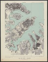
- Beinecke Rare Book and Manuscript Library > Vancouver Island / Army Map Service.
- Creator:
- United States. Army Map Service
- Published / Created:
- 1943
- Call Number:
- 493 V24 1943
- Container / Volume:
- BRBL_00270
- Image Count:
- 1
- Resource Type:
- Maps, Atlases & Globes
- Found in:
- Beinecke Rare Book and Manuscript Library > Valletta city plan [cartographic material] / prepared under the direction of the Chief of Engineers, U.S. Army 1943.
- Published / Created:
- 1909
- Call Number:
- 75cfe 1909
- Container / Volume:
- BRBL_00409
- Image Count:
- 1
- Resource Type:
- Maps, Atlases & Globes
- Found in:
- Beinecke Rare Book and Manuscript Library > United States, Contour Map.
- Creator:
- National Geographic Society (U.S.). Cartographic Section
- Published / Created:
- c1944.
- Call Number:
- 35 1944
- Container / Volume:
- BRBL_00101
- Image Count:
- 1
- Resource Type:
- Maps, Atlases & Globes
- Found in:
- Beinecke Rare Book and Manuscript Library > Union of Soviet Socialist Republics International boundaries according to Russian treaties and claims as of October 1, 1944 ; Boundaries of January 1, 1938, are shown in red Compiled and drawn in the Cartographic Section of the National Geographic Society