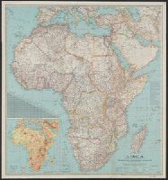
National Geographic Society (U.S.). Cartographic Section
Published / Created:
c1943.
Call Number:
60 1943
Container / Volume:
BRBL_00329
Image Count:
1
Resource Type:
Maps, Atlases & Globes
Description:
"International boundaries as of Sept. 1, 1939.", Includes a chart of airline distances., Inset: Relief. Scale 562 miles to 1 inch., Issued with the National Geographic magazine, v. 83, no. 2, February 1943., and Relief shown by hachures and spot heights.
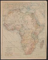
Copyright, 1909, by the J.N. Matthews Co., Buffalo, N.Y., Relief shown by hachures and spot heights., and Suppl. to The National Geographic Magazine, March 1909.
Publisher:
National Geographic Society,
Subject (Geographic):
Africa--Maps
Subject (Name):
Grosvenor, Gilbert Hovey, 1875-1966, J.N. Matthews Co, and National Geographic Society (U.S.)