Search
You Searched For
Search Results
- Creator:
- National Geographic Society (U.S.). Cartographic Section
- Published / Created:
- 1945
- Call Number:
- 56 1945
- Container / Volume:
- BRBL_00296
- Image Count:
- 1
- Resource Type:
- Maps, Atlases & Globes
- Found in:
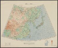
- Beinecke Rare Book and Manuscript Library > China [cartographic material] / compiled and drawn in the Cartographic Section of the National Geographic Society for the National Geographic Magazine ; James M. Darley, chief cartographer.
- Creator:
- Great Britain. War Office. General Staff. Geographical Section
- Published / Created:
- 1943
- Call Number:
- 56cbf 1942
- Container / Volume:
- BRBL_00297
- Image Count:
- 1
- Resource Type:
- Maps, Atlases & Globes
- Found in:
- Beinecke Rare Book and Manuscript Library > China and Japan [cartographic material] / compiled from G.S.G.S. 4065 and 2957.
- Creator:
- United States. Army Map Service
- Published / Created:
- 1945
- Call Number:
- 56 F73 1945
- Container / Volume:
- BRBL_00296
- Image Count:
- 1
- Resource Type:
- Maps, Atlases & Globes
- Found in:
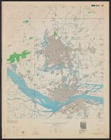
- Beinecke Rare Book and Manuscript Library > China city plans 1:12,500. Fu-chou and Nan-ta̓i / prepared under the direction of the Chief of Engineers by the Army Map Service (AM) ... 1945 [cartographic material].
- Creator:
- United States. Office of Strategic Services. Research and Analysis Branch
- Published / Created:
- 1944
- Call Number:
- 56cbf 1944
- Container / Volume:
- BRBL_00297
- Image Count:
- 1
- Resource Type:
- Maps, Atlases & Globes
- Found in:
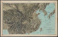
- Beinecke Rare Book and Manuscript Library > China, terrain and transportation [cartographic material] / compiled and drawn in the Branch of Research and Analysis, OSS.
- Creator:
- United States. Army Map Service
- Published / Created:
- 1942
- Call Number:
- 6547 C74 1945
- Container / Volume:
- BRBL_00344
- Image Count:
- 1
- Resource Type:
- Maps, Atlases & Globes
- Found in:
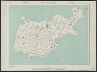
- Beinecke Rare Book and Manuscript Library > City plan of Conakry.
- Creator:
- National Geographic Society (U.S.). Cartographic Division
- Published / Created:
- c1978.
- Call Number:
- 844 1978
- Container / Volume:
- BRBL_00603
- Image Count:
- 2
- Resource Type:
- Maps, Atlases & Globes
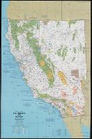
- Found in:
- Beinecke Rare Book and Manuscript Library > Close-up: U.S.A., California and Nevada / produced by the Cartographic Division, National Geographic Society ; William T. Peele, chief cartographer, David W. Cook, associate chief cartographer.
- Creator:
- National Geographic Society (U.S.). Cartographic Division
- Published / Created:
- c1977.
- Call Number:
- 7821 1977
- Container / Volume:
- BRBL_00506
- Image Count:
- 2
- Resource Type:
- Maps, Atlases & Globes
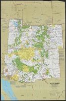
- Found in:
- Beinecke Rare Book and Manuscript Library > Close-up: U.S.A., the Southwest / produced by the Cartographic Division, National Geographic Society ; William T. Peele, chief cartographer ; Richard K. Rogers, assistant chief cartographer.
- Creator:
- United States. Army Map Service
- Published / Created:
- 1943
- Call Number:
- 38 C71 1943
- Container / Volume:
- BRBL_00157
- Image Count:
- 1
- Resource Type:
- Maps, Atlases & Globes
- Found in:
- Beinecke Rare Book and Manuscript Library > Colmar [cartographic material] : city plan / prepared under the direction of the Chief of Engineers, U.S. Army, 1943.
- Creator:
- U.S. Coast and Geodetic Survey
- Published / Created:
- 1900
- Call Number:
- 767cea 1900
- Container / Volume:
- BRBL_00476
- Image Count:
- 1
- Resource Type:
- Maps, Atlases & Globes
- Found in:
- Beinecke Rare Book and Manuscript Library > Connecticut River, Deep River to Higganum, Connecticut / U.S. Coast and Geodetic Survey.
- Published / Created:
- [190?]
- Call Number:
- 28hc 1900A
- Container / Volume:
- BRBL_00024
- Image Count:
- 1
- Resource Type:
- Maps, Atlases & Globes
- Found in:
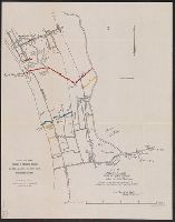
- Beinecke Rare Book and Manuscript Library > Copy of map furnished to commanding officers, 2nd Brig., 2nd Div., 8th Army Corps, on August 12, 1898.