Search
You Searched For
Search Results
- Creator:
- American Geographical Society of New York
- Published / Created:
- [1918?]
- Call Number:
- 11hcf 1919-14
- Container / Volume:
- BRBL_00010J
- Image Count:
- 1
- Resource Type:
- Maps, Atlases & Globes
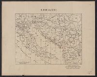
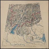
- Description:
- Ms. notes showing Italian land claims following World War I.
- Publisher:
- American Geographical Society,
- Subject (Geographic):
- Adriatic Sea Region--Maps
- Subject (Topic):
- World War, 1914-1918--Maps
- Found in:
- Beinecke Rare Book and Manuscript Library > Adriatic [Sea region].
- Creator:
- American Geographical Society of New York
- Published / Created:
- [1914?]
- Call Number:
- 11hcf 1919B-13
- Container / Volume:
- BRBL_00010O
- Image Count:
- 3
- Resource Type:
- Maps, Atlases & Globes
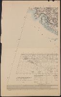
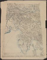
- Description:
- Sheet 2 fragile, in 3 fragments.
- Publisher:
- American Geographical Society,
- Subject (Geographic):
- Austria--Maps and Europe, Eastern--Maps
- Found in:
- Beinecke Rare Book and Manuscript Library > Austria-Hungary [cartographic material].
- Creator:
- American Geographical Society of New York
- Published / Created:
- 1918
- Call Number:
- 44cbd 1918
- Container / Volume:
- BRBL_00256
- Image Count:
- 4
- Resource Type:
- Maps, Atlases & Globes
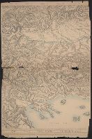
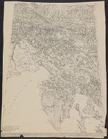
- Description:
- "Topography is based particularly upon the Generalkarte von Mitteleuropa of the Austrian General Staff (Scale 1:300,000)."
- Publisher:
- The American Geographical Society,
- Subject (Geographic):
- Balkan Peninsula--Maps
- Subject (Topic):
- Slopes (Physical geography)--Balkan Peninsula--Maps
- Found in:
- Beinecke Rare Book and Manuscript Library > Block diagram showing terrain of the Balkan Peninsula [cartographic material].
- Creator:
- American Geographical Society of New York
- Published / Created:
- [1918]
- Call Number:
- 11hcf 1919C-2
- Container / Volume:
- BRBL_00010T
- Image Count:
- 2
- Resource Type:
- Maps, Atlases & Globes
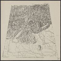
- Description:
- Relief shown by shading and spot heights.
- Publisher:
- The American Geographical Society,
- Subject (Geographic):
- Balkan Peninsula--Maps
- Subject (Topic):
- Slopes (Physical geography)--Balkan Peninsula--Maps
- Found in:
- Beinecke Rare Book and Manuscript Library > Block diagram showing terrain of the Balkan Peninsula.
- Creator:
- American Geographical Society of New York
- Published / Created:
- 19--?]
- Call Number:
- 11hcf 1919D-8
- Container / Volume:
- BRBL_00010Y
- Image Count:
- 1
- Resource Type:
- Maps, Atlases & Globes
- Description:
- Copy, at reduced scale, of diagram issued by the American Geographical Society.
- Subject (Geographic):
- Trentino-Alto Adige (Italy)--Block diagrams
- Found in:
- Beinecke Rare Book and Manuscript Library > Block diagram showing terrain of the Trentino region [cartographic material].
- Creator:
- American Geographical Society of New York
- Published / Created:
- 19--?]
- Call Number:
- 11hcf 1919E-26
- Container / Volume:
- BRBL_00010ZA
- Image Count:
- 1
- Resource Type:
- Maps, Atlases & Globes
- Description:
- Copy, at reduced scale, of diagram issued by the American Geographical Society.
- Subject (Geographic):
- Trentino-Alto Adige (Italy)--Block diagrams
- Found in:
- Beinecke Rare Book and Manuscript Library > Block diagram showing terrain of the Trentino region [cartographic material].
- Creator:
- American Geographical Society of New York
- Published / Created:
- 1918
- Call Number:
- 11hcf 1919E
- Image Count:
- 1
- Resource Type:
- Maps, Atlases & Globes
- Description:
- "Approximate scale in center of diagram 1:150,000, vertical exaggeration about 1 1/2 times."
- Publisher:
- American Geographical Society,
- Subject (Geographic):
- Friuli (Italy)--Maps, Istria (Croatia and Slovenia)--Maps, and Trieste Region (Italy)--Maps
- Subject (Topic):
- Block diagrams--Friuli (Italy : Province) and Block diagrams--Istria (Croatia and Slovenia)
- Found in:
- Beinecke Rare Book and Manuscript Library > Block diagram showing terrain of the Trieste-Isonzo region.
- Creator:
- American Geographical Society of New York
- Published / Created:
- [ca. 1914]
- Call Number:
- 403cbd 1900A
- Container / Volume:
- BRBL_00234
- Image Count:
- 1
- Resource Type:
- Maps, Atlases & Globes
- Description:
- "Approximate scale in center of diagram 1:150,000, vertical exaggeration about 1 1/2 times."
- Publisher:
- American Geographical Society,
- Subject (Geographic):
- Friuli (Italy)--Maps, Istria (Croatia and Slovenia)--Maps, and Trieste Region (Italy)--Maps
- Subject (Topic):
- Block diagrams--Friuli (Italy : Province) and Block diagrams--Istria (Croatia and Slovenia)
- Found in:
- Beinecke Rare Book and Manuscript Library > Block diagram showing terrain of the Trieste-Isonzo region.
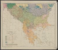
- Creator:
- American Geographical Society of New York
Briesemeister, William A
Cvijić, Jovan, 1865-1927
- Published / Created:
- c1918.
- Call Number:
- 11hcf 1919D-47
- Image Count:
- 1
- Resource Type:
- Maps, Atlases & Globes
- Description:
- "Drawn by Wm. Briesemeister."
- Publisher:
- American Geographical Society of New York,
- Subject (Geographic):
- Balkan Peninsula--Maps
- Subject (Topic):
- Ethnology--Balkan Peninsula--Maps
- Found in:
- Beinecke Rare Book and Manuscript Library > Ethnographic map of the Balkan Peninsula / by Jovan Cvijić.
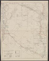
- Creator:
- American Geographical Society of New York
- Published / Created:
- 1929
- Call Number:
- 923 1929
- Container / Volume:
- BRBL_00673
- Image Count:
- 1
- Resource Type:
- Maps, Atlases & Globes
- Description:
- "Contours and altitudes in meters."
- Publisher:
- American Geographical Society of New York,
- Subject (Geographic):
- Chaco Boreal (Paraguay and Bolivia)--Maps
- Subject (Topic):
- Chaco War, 1932-1935--Maps
- Found in:
- Beinecke Rare Book and Manuscript Library > Map of the Chaco Boreal [cartographic material] / compiled by the American Geographical Society of New York.