Search
You Searched For
Search Results
- Creator:
- Geological Survey (U.S.)
- Published / Created:
- 1910
- Call Number:
- BrSides Double Folio 2019 84
- Image Count:
- 1
- Resource Type:
- Maps, Atlases & Globes
- Found in:
- Beinecke Rare Book and Manuscript Library > Colorado (Lake County), Leadville special map [cartographic material] / triangulation and topography by A.D. Wilson, chief topographer.
- Creator:
- Geological Survey (U.S.)
- Published / Created:
- 1906
- Call Number:
- BrSides Folio 2019 61
- Image Count:
- 1
- Resource Type:
- Maps, Atlases & Globes
- Found in:
- Beinecke Rare Book and Manuscript Library > Colorado, Central City special map [cartographic material] / U.S. Geological Survey ; E.M. Douglas, geographer ; Frank Tweedy, in charge of section ; topography by Pearson Chapman and D.F. Moor ; triangulation by Frank Tweedy.
- Creator:
- Geological Survey (U.S.)
- Published / Created:
- 1916
- Call Number:
- 304ed 1916
- Container / Volume:
- BRBL_00034A
- Image Count:
- 1
- Resource Type:
- Maps, Atlases & Globes
- Found in:
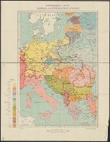
- Beinecke Rare Book and Manuscript Library > Ethnographical Map of Central & South Eastern Europe.
- Creator:
- Geological Survey (U.S.)
- Published / Created:
- 1905?]
- Call Number:
- 837gce T764 1905
- Container / Volume:
- BRBL_00594
- Image Count:
- 1
- Resource Type:
- Maps, Atlases & Globes
- Found in:
- Beinecke Rare Book and Manuscript Library > General map of Truckee-Carson Project, Nevada / U.S. Geological Survey.
- Creator:
- Geological Survey (U.S.)
- Published / Created:
- 1905?]
- Call Number:
- 847 Y12 1905
- Container / Volume:
- BRBL_00627
- Image Count:
- 1
- Resource Type:
- Maps, Atlases & Globes
- Found in:
- Beinecke Rare Book and Manuscript Library > General map of the Yakima Basin, Washington.
- Creator:
- Geological Survey (U.S.)
- Published / Created:
- 1912
- Call Number:
- 848 G95 1912
- Container / Volume:
- BRBL_00632
- Image Count:
- 1
- Resource Type:
- Maps, Atlases & Globes
- Found in:
- Beinecke Rare Book and Manuscript Library > Geologic reconnaissance map of headwater region of Gulkana and Susitna Rivers, Alaska / U.S. Geological Survey. Alfred H. Brooks, geologist in charge of division, topography and triangulation by D.C. Witherspoon, C.E. Giffin and J.W. Bagley.
- Creator:
- Geological Survey (U.S.)
- Published / Created:
- [1918]
- Call Number:
- 848 J953 1918
- Container / Volume:
- BRBL_00633
- Image Count:
- 1
- Resource Type:
- Maps, Atlases & Globes
- Found in:
- Beinecke Rare Book and Manuscript Library > Juneau and vicinity, Alaska / Alfred H. Brooks, geologist in charge of division ; topography by D.C. Witherspoon.
- Creator:
- Geological Survey (U.S.)
- Published / Created:
- [1900]
- Call Number:
- 847gc Se18 1897
- Container / Volume:
- BRBL_00628
- Image Count:
- 1
- Resource Type:
- Maps, Atlases & Globes
- Found in:
- Beinecke Rare Book and Manuscript Library > Land classification and density of standing timber, Washington, Seattle quadrangle / U.S. Geological Survey.
- Creator:
- Geological Survey (U.S.)
- Published / Created:
- [1900]
- Call Number:
- 847gc T119 1897
- Container / Volume:
- BRBL_00628
- Image Count:
- 1
- Resource Type:
- Maps, Atlases & Globes
- Found in:
- Beinecke Rare Book and Manuscript Library > Land classification and density of standing timber, Washington, Tacoma quadrangle / U.S. Geological Survey.
- Creator:
- Geological Survey (U.S.)
- Published / Created:
- 1913
- Call Number:
- BrSides Double Folio 2019 127
- Image Count:
- 1
- Resource Type:
- Maps, Atlases & Globes
- Found in:
- Beinecke Rare Book and Manuscript Library > Leadville mining district [cartographic material] / U.S. Geological Survey ; R.B. Marshall, chief geographer ; Sledge Tatum, geographer in charge ; topography by E.P. Davis and S.E. Taylor ; control by R.B. Robertson, C.H. Semper, and S.E. Taylor.