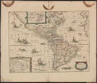
Includes col. ill. of ships, monsters, etc., Possibly from the 1639, 1641, or 1642 ed. of the author's Noveau theatre du monde ou nouvel atlas, or from the 1646, 1647, or 1649 ed. of J. Jansson's Nouvel atlas ou theatre du monde., and Relief shown pictorially.
Appears in various eds. of Jan Jansson's Nouvel atlas., French text on verso., Includes ill. of ships and sea monsters, and insets showing "Polus Arcticus" region and "Terra Australis inc, and Sheet measures 50 x 59 cm. Stamp on verso: Yale, Horace Brown, 1900S.
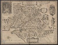
French text on verso, with running and caption title "Virginie," signature e, and catchword "ses.", From Jan Jansson's Nouvel atlas ... Amstelodami : Apud Ioannem Ianssonium, 1646-1649., Hendrik Hondius' derivative of John Smith's map of Virginia, 1612., and Ori
Publisher:
Ex officina Henrici Hondii,
Subject (Geographic):
Chesapeake Bay (Md. and Va.)--Maps--Early works to 1800, Maryland--Maps--Early works to 1800, and Virginia--Maps--Early works to 1800
Subject (Name):
Jansson, Jan, 1588-1664. Atlas novus. French and Smith, John, 1580-1631
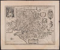
Hendrik Hondius' derivative of John Smith's map of Virginia, 1612., Oriented with north to the right., Relief shown pictorially., Sheet measures 47.6 x 57.7 cm. Franklin Collection no. 131 1633., and Verso in French, with running and caption title "Description de la Virginie," signatures 8O2, and catchword "peu".
Publisher:
Ex officina Henrici Hondii,
Subject (Geographic):
Chesapeake Bay (Md. and Va.)--Maps--Early works to 1800, Maryland--Maps--Early works to 1800, and Virginia--Maps--Early works to 1800
Subject (Name):
Jansson, Jan, 1588-1664. Atlas novus. French and Smith, John, 1580-1631