- Creator:
- Jansson, Jan, 1588-1664
- Published / Created:
- [between 1641 and 1658?]
- Call Number:
- 70 165X
- Container / Volume:
- BRBL_00353
- Image Count:
- 2
- Resource Type:
- Maps, Atlases & Globes
- Description:
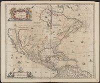
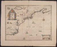
- Covers North America, Cent, Dutch text on verso, with signature "Bb.", Relief shown pictorially., and State 2, first issued in 1641, according to Burden; matches description of Dutch text versions appearing in Nieuwen atlas editions 1645, '47, '52, '53, and '58.
- Publisher:
- excudit Ioannes Ianssonius,
- Subject (Geographic):
- North America--Maps--Early works to 1800
- Subject (Name):
- Jansson, Jan, 1588-1664. Atlas novus. Dutch
- Found in:
- Beinecke Rare Book and Manuscript Library > America Septentrionalis.
You Searched For
1 - 6 of 6
Search Results
- Creator:
- Jansson, Jan, 1588-1664
- Published / Created:
- [1652?]
- Call Number:
- 70 165XA
- Container / Volume:
- BRBL_00353
- Image Count:
- 2
- Resource Type:
- Maps, Atlases & Globes
- Description:
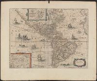
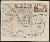
- Appears in various eds. of Jansson's Nieuwen atlas., Dutch text on verso., Includes ill. of ships and sea monsters, and insets showing "Polus Arcticus" region and "Terra Australis incognita.", Relief shown pictorially., and Sheet measures 50.1 x 60.9 cm.
- Publisher:
- Excudit Ioannes Ianssonius,
- Subject (Geographic):
- America--Maps--Early works to 1800
- Subject (Name):
- Jansson, Jan, 1588-1664. Atlas novus. Dutch
- Found in:
- Beinecke Rare Book and Manuscript Library > America noviter delineata.
- Creator:
- Jansson, Jan, 1588-1664
- Published / Created:
- ca. 1662]
- Call Number:
- 38 1662A
- Container / Volume:
- BRBL_00151
- Image Count:
- 2
- Resource Type:
- Maps, Atlases & Globes
- Alternative Title:
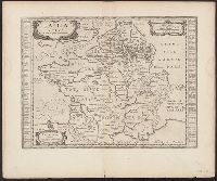
- Atlas novus. and Gallia vetus ad Julij Caesaris commentaria
- Description:
- Latin text on recto; Dutch text on verso., Lower left corner: "Amstelodami apud Ioannem Ianβonium.", Published in Dutch editions of Jansson's Atlas novus (Dutch title: Nieuwen atlas, ofte vveerelts-beschrijvinge), vol. 6, ca. 1662, and Relief shown pictorially.
- Publisher:
- Jan Jansson,
- Subject (Geographic):
- France--History--To 987--Maps--Early works to 1800 and Gaul--Maps--Early works to 1800
- Subject (Name):
- Jansson, Jan, 1588-1664. Atlas novus. Dutch
- Found in:
- Beinecke Rare Book and Manuscript Library > Gallia vetvs ad Iulij Caesaris commentaria.
- Creator:
- Jansson, Jan, 1588-1664
- Published / Created:
- [1645]
- Call Number:
- 85 1652
- Container / Volume:
- BRBL_00636
- Image Count:
- 2
- Resource Type:
- Maps, Atlases & Globes
- Alternative Title:
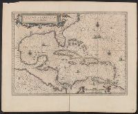
- Insulae Americanae in Oceano Septentrionali cum terris adjacentibus and Insvlae Americanae in Oceano Septentrionali cum terris adiacentibus
- Description:
- Appears in various Dutch eds. of Jansson's Nieuwen atlas., Includes scales in milliaria germanica and mill, and Shows southeast coast of North America from Virginia to north coast of South America to east of Trinidad, west coast of Central America, West Indies.
- Publisher:
- Apud Ioannem Ianssonium,
- Subject (Geographic):
- Caribbean Area--Maps--Early works to 1800, Mexico, Gulf of--Maps--Early works to 1800, and West Indies--Maps--Early works to 1800
- Subject (Name):
- Jansson, Jan, 1588-1664. Atlas novus. Dutch
- Subject (Topic):
- Coasts--North America--Maps--Early works to 1800 and Coasts--South America--Maps--Early works to 1800
- Found in:
- Beinecke Rare Book and Manuscript Library > Insulae Americanae in Oceano Septentrionali cum terris adiacentibus [cartographic material].
- Creator:
- Jansson, Jan, 1588-1664
- Published / Created:
- [1645]
- Call Number:
- 755 1652A
- Container / Volume:
- BRBL_00423
- Image Count:
- 2
- Resource Type:
- Maps, Atlases & Globes
- Description:
- Appears in Dutch editions of Jansson's Atlas novus., Dutch text on verso, with catchword "West-Indien" and signature 2C., Hand col. Sheet measures 50 x 60.5 cm., Ill. of animals and Indian village., and Relief shown pictorially.
- Publisher:
- Johannes Janssonius excudit,
- Subject (Geographic):
- Atlantic States--Maps--Early works to 1800 and Maritime Provinces--Maps--Early works to 1800
- Subject (Name):
- Jansson, Jan, 1588-1664. Atlas novus. Dutch
- Found in:
- Beinecke Rare Book and Manuscript Library > Nova Belgica et Anglia Nova.
- Creator:
- Jansson, Jan, 1588-1664
- Published / Created:
- [1650]
- Call Number:
- 49 1650
- Container / Volume:
- BRBL_00267
- Image Count:
- 2
- Resource Type:
- Maps, Atlases & Globes
- Alternative Title:
- Tabula hydrographica de partibus orientalioribus Maris Mediterranei
- Description:
- Dutch text on verso. and Includes decorative cartouche, rhumb lines, and indexes of islands.
- Publisher:
- Apud Ioannem Ianssonium,
- Subject (Geographic):
- Mediterranean Sea--Maps--Early works to 1800
- Subject (Topic):
- Nautical charts--Mediterranean Sea--Early works to 1800
- Found in:
- Beinecke Rare Book and Manuscript Library > Pascaarte Van't oostelyckste deel vande Middelandsche Zee : vertonende in sich de ware gelegentheden van alle capen, havens, rivieren, bayen en droogtē, zynde alles op zyn behoorlycke streckingen en distantiē geleyt = Tabula hydrographica de partibus or