Skip to search
Skip to main content
Skip to first result
Search
You Searched For
Date
1650 - 1651
Language
Dutch; Flemish
Creator
Jansson, Jan, 1588-1664
Date Created
1650 to 1651
New Search
Search Results
Creator:
Published / Created:
[between 1641 and 1658?]
Call Number:
70 165X
Container / Volume:
BRBL_00353
Image Count:
2
Resource Type:
Maps, Atlases & Globes
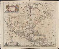
Description:
Covers North America, Cent, Dutch text on verso, with signature "Bb.", Relief shown pictorially., and State 2, first issued in 1641, according to Burden; matches description of Dutch text versions appearing in Nieuwen atlas editions 1645, '47, '52, '53, and '58.
Publisher:
excudit Ioannes Ianssonius,
Subject (Geographic):
North America--Maps--Early works to 1800
Subject (Name):
Jansson, Jan, 1588-1664. Atlas novus. Dutch
Found in:
Beinecke Rare Book and Manuscript Library > America Septentrionalis.
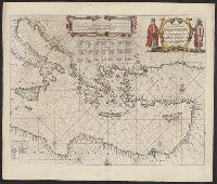
Creator:
Published / Created:
[1650]
Call Number:
49 1650
Container / Volume:
BRBL_00267
Image Count:
2
Resource Type:
Maps, Atlases & Globes
Alternative Title:
Tabula hydrographica de partibus orientalioribus Maris Mediterranei
Description:
Dutch text on verso. and Includes decorative cartouche, rhumb lines, and indexes of islands.
Publisher:
Apud Ioannem Ianssonium,
Subject (Geographic):
Mediterranean Sea--Maps--Early works to 1800
Subject (Topic):
Nautical charts--Mediterranean Sea--Early works to 1800
Found in:
Beinecke Rare Book and Manuscript Library > Pascaarte Van't oostelyckste deel vande Middelandsche Zee : vertonende in sich de ware gelegentheden van alle capen, havens, rivieren, bayen en droogtē, zynde alles op zyn behoorlycke streckingen en distantiē geleyt = Tabula hydrographica de partibus or
Branch:v1.61.6 ,Deployed:2024-06-12T09:55:19-04:00