
Search


Limit your search
- Public✖[remove]27
- Maps, Atlases & Globes✖[remove]27
- English16
- Jefferys, Thomas, d. 1771✖[remove]27
- Bowen, Emanuel, d. 17671
- Hoüel, Jean-Pierre-Laurent, 1735-18131
- Nautical charts4
- Coasts--Europe, Western--Maps--Early works to 18002
- Nautical charts--Europe, Western--Early works to 18002
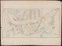
- Nautical charts--Saint Lawrence River--Early works to 18002
- Coasts--Africa, West--Maps--Early works to 18001
- Coasts--Gulf States--Maps--Early works to 18001
- Coasts--Louisiana--Maps--Early works to 18001
- Coasts--Texas--Maps--Early works to 18001
- Fortification--Nova Scotia--Louisbourg--Maps--Early works to 18001
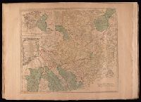
- Minden, Battle of, Germany, 1759--Maps1
- Sayer, Robert, 1725-17946
- Anville, Jean Baptiste Bourguignon d', 1697-17824
- Jefferys, Thomas, d. 1771. American atlas3
- Kitchin, Thomas, d. 1784. General atlas describing the whole universe3
- Robert Laurie and James Whittle2
- Abbot, Charles,--Baron Colchester,--1757-1829--Bookplate1
- Bowen, Emanuel, d. 17671
- Cook, James, 1728-17791
- Evans, Lewis, 1700?-17561
- Gridley, Richard, 1711-17961