From Jefferys's The American atlas ... London : Printed and sold by R. Sayer and J. Bennett, 1776., Hand col. Sheet measures 55.1 x 73.5 cm. Stamped no. on verso: 12. Cross Collection no. 160., and Relief shown pictorially. Depths shown by soundings.
Publisher:
By Thomas Jefferys, geographer to the King, printed for Robt. Sayer & Jno. Bennett,
Subject (Geographic):
Newfoundland, Island of (N.L.)--Maps--Early works to 1800
Subject (Name):
Cook, James, 1728-1779, Jefferys, Thomas, d. 1771. American atlas, Lane, Michael, fl. 1768-1784, and Robert Sayer and John Bennett (Firm)
Includes historical notes, text, 3 distance charts, and inset of "A sketch of the remaining part of Ohio R. &c.", Prime meridians: Philadelphia and London., and Relief shown pictorially.
Publisher:
Sold by R. Sayer in Fleet Street & T. Jefferys, Charing Cross,
Subject (Geographic):
Northeastern States--Maps--Early works to 1800
Subject (Name):
Evans, Lewis, 1700?-1756 and Sayer, Robert, 1725-1794
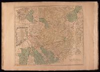
Electorate of Brunswick-Luneburg with its dependencies
Description:
Imperfect: torn along fold, with some loss of text. Sheet measures 75.0 x 62.4 cm. No. 30 of 34 maps bound together., Inset map: Plan of the battle of Minden on the 1st of August 1759., Prime meridian: Ferro., and Relief shown pictorially.
Bar scales given in "German miles 15 to a degree" and "English statute miles 69 & 1/2 to a degree"., Prime meridian: Ferro., Relief shown pictorially., Sheet measures 54.5 x 72.2 cm. No. 29 of 34 maps bound together., Title of inset map: East-Frieseland, lordship of Jever and the counties of Oldenburg and Delmenhorst., and Watermark.
Publisher:
Thomas Jefferys,
Subject (Geographic):
Lower Saxony (Germany)--Maps--Early works to 1800 and North Rhine-Westphalia (Germany)--Maps--Early works to 1800
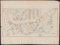
[Gulf of St. Laurence] -- The contents of the respective divisions of the island of St. John -- A list of lots and proprietors names., Depths shown by soundings., and Hand col. Sheet measures 55.2 x 73.8 cm. Cross Collection no. 172.
Publisher:
R. Sayer & J. Bennett?],
Subject (Geographic):
Prince Edward Island--Administrative and political divisions--Maps--Early works to 1800
Subject (Name):
Holland, Samuel, 1728-1801
Subject (Topic):
Real property--Prince Edward Island--Maps--Early works to 1800
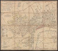
Map of Gabarus Bay adjoyning to Louisburg. and Plan of the city and harbour of Louisburg.
Description:
"Octob. 9, 1758." and Includes text, index to fortification, "The profile," and insets of "A plan of the city and harbour of Louisburg ... during the siege in 1758" and "A map of Gabarus Bay, adjoyning to Louisburg."
Publisher:
Thos. Jeffreys,
Subject (Geographic):
Louisbourg (N.S.)--Buildings, structures, etc.--Maps--Early works to 1800, Louisbourg (N.S.)--History--Siege, 1745--Maps--Early works to 1800, and Louisbourg (N.S.)--Maps--Early works to 1800
Subject (Name):
Gridley, Richard, 1711-1796
Subject (Topic):
Fortification--Nova Scotia--Louisbourg--Maps--Early works to 1800
Appears in Thomas Kitchin's General atlas describing the whole universe., Inc, Mounted on linen. Sheet measures 64.4 x 101 cm. Cross Collection no. 176., Relief shown pictorially. Soundings shown in fathoms., and With dedication to John Montagu, Earl of Sandwich.
Publisher:
Printed for Robt. Sayer, map & printseller,
Subject (Geographic):
Saint Lawrence River Valley--Maps--Early works to 1800 and Saint Lawrence River--Maps--Early works to 1800
Subject (Name):
Kitchin, Thomas, d. 1784. General atlas describing the whole universe and Sayer, Robert, 1725-1794
Subject (Topic):
Nautical charts--Saint Lawrence River--Early works to 1800
Appears in Thomas Kitchin's General atlas describing the whole universe., Includes text., and Insets: The Seven Islands -- A continuation of the river from Quebec to Lake Ontario -- St. Nicholas or English Harbor -- The mountains of our Lady or Notre Dame -- Th
Publisher:
Printed for Robt. Sayer, map & printseller,
Subject (Geographic):
Saint Lawrence River Valley--Maps--Early works to 1800 and Saint Lawrence River--Maps--Early works to 1800
Subject (Name):
Kitchin, Thomas, d. 1784. General atlas describing the whole universe and Sayer, Robert, 1725-1794
Subject (Topic):
Nautical charts--Saint Lawrence River--Early works to 1800