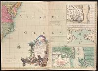
Includes text and illustrations., Insets: Plan of the town of Halifax in Nova Scotia -- Plan du port et ville de Louisbourg dans l'Isle Royale -- Plan de la ville de Quebec -- A new map of Hudsons Bay and Labrador from the late surveys of those coasts., Prime meridian: London., Relief shown pictorially., Second Dutch edition., and Sheets joined to form four separate sheets.
First edition, first issue with Millar's name and Katharine Street in imprint misspelled Miller and Katherine, respectively. Two cities in Massachusetts are named Leicester, and none is named Worcester. and For a description of different editions and impressi
Publisher:
Publish'd by the author Febry 13th, 1755 according to the act of Parliament, and sold by And. Miller, opposite Katherine Street in the Strand,
Subject (Geographic):
NorthAmerica--Maps--Early works to
Subject (Name):
Kitchin, Thomas, 1718-1784 and Millar, Andrew, 1705-1768
"Longitude west from London.", First impression of 3d ed., Includes text and inset "A new map of Hudson's Bay and Labrador from the late surveys of those coasts.", and Relief shown pictorially.
Publisher:
Printed for Jefferys and Faden, geographers to the King,
Subject (Geographic):
NorthAmerica--Maps--Early works to
Subject (Name):
Jefferys and Faden, London and Kitchin, Thomas, d. 1784
Fourth ed., In bottom margin: Publish'd by the author Febry 13th 1755 according to act of Parliament., Includes text and inset "A new map of Hudson's Bay and Labrador from the late surveys of those coasts.", Relief shown pictorially., and Yale's copy stamped on b
Publisher:
Printed for Jefferys and Faden, geographers to the King,
Subject (Geographic):
NorthAmerica--Maps--Early works to
Subject (Name):
Jefferys and Faden, London and Kitchin, Thomas, d. 1784
First impression of 3d French ed., Includes text and inset "Nouvelle carte de la baye d'Hudson et de Labrador selon les dernieres cartes levées sur les lieux.", Prime meridian: London., Relief shown pictorially., and Title in French and German.
Subject (Geographic):
NorthAmerica--Maps--Early works to
Subject (Name):
Hawkins, M., fl. 1776-1792 and Le Rouge, Georges-Louis
4th impression of 3d French ed. Cf. Ristow, W.W. A la carte, p. 112., Includes text and inset "Nouvelle carte de la baye d'Hudson et de Labrador selon les dernieres cartes levées sur les lieux.", Prime meridian: London., Relief shown pictorially., and Title in F
Publisher:
Le Rouge?,
Subject (Geographic):
NorthAmerica--Maps--Early works to
Subject (Name):
Hawkins, M., fl. 1776-1792 and Le Rouge, Georges-Louis
First edition, first issue with Millar's name and Katharine Street in imprint misspelled Miller and Katherine, respectively. Two cities in Massachusetts are named Leicester, and none is named Worcester., For a description of different editions and impressions, see the Osher Map Library (http://oshermaps.org/special-map-exhibits/mitchell-map/cartographic-notes)., Includes text and inset "A new map of Hudson's Bay and Labrador from the late survey of those coasts.", Prime meridian: London., and Relief shown pictorially.
Publisher:
Publish'd by the author Febry 13th, 1755 according to the act of Parliament, and sold by And. Miller, opposite Katherine Street in the Strand,
Subject (Geographic):
NorthAmerica--Maps--Early works to
Subject (Name):
Kitchin, Thomas, 1718-1784 and Millar, Andrew, 1705-1768