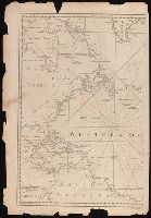
Also appeared in Kitchin's General atlas describing the whole universe. London : Printed for Robert Sayer, [1780]., Includes descriptive notes and text "Division of South America with a summary account of its trade," and large ornamental cartouche., Inset map: Chart of the Falkland's Islands : named by the French Malouine Islands, and discovered by Hawkins in the year 1595. Scale [ca. 1:2,000,000]., Prime meridian: Ferro., Relief shown pictorially; depths by soundings., Sheets measures 54 x 122.7 cm., and Sheets mounted together to form 2 sheets.
Publisher:
Printed for Robert Sayer,
Subject (Geographic):
Falkland Islands--Maps--Early works to 1800 and South America--Maps--Early works to 1800
Subject (Name):
Anville, Jean Baptiste Bourguignon d', 1697-1782, Kitchin, Thomas, d. 1784, and Kitchin, Thomas, d. 1784. General atlas describing the whole universe
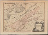
Includes insets of "A particular survey of the Isles of Montreal" and "Course of the river St. Laurence, from La Valterie to Quebec," and indexed insets of "The city of Quebec" and "Plan of Montreal, or Víllemarie.", Relief shown pictorially., and Stamp of Wil
Publisher:
Printed for Robert Sayer, no. 53 Fleet Street,
Subject (Geographic):
Québec (Province)--Maps--Early works to 1800
Subject (Name):
Carver, Jonathan, 1710-1780 and Morse, William Inglis,--b. 1874--Stamp
Kitchin, Thomas, d. 1784, creator Sayer, Robert, 1725-1794
Published / Created:
1787 January 1
Call Number:
1982 Folio 10
Image Count:
1
Description:
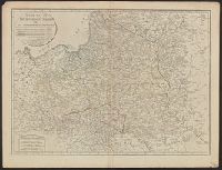
Also appeared in Kitchin's General atlas describing the whole universe. London : Printed for Robert Sayer, [1780]., Ms. notes in contemporary hand., No. 23 of 43 maps bound together in composite atlas., Relief shown pictorially., Scale [ca. 1:2,450,000]., and Shows vegetation, marshes, etc.
Publisher:
Robert Sayer
Subject (Geographic):
Europe, Eastern --Maps --Early works to 1800, Lithuania --Boundaries --Maps --Early works to 1800, Lithuania --Maps --Early works to 1800, Poland --Boundaries --Maps --Early works to 1800, and Poland --Maps --Early works to 1800
Kitchin, Thomas, d. 1784 Kitchin, Thomas, d. 1784. General atlas describing the whole universe Sayer, Robert, 1725-1794
Published / Created:
January 1st, 1787.
Call Number:
356 1787
Container / Volume:
BRBL_00114
Image Count:
1
Resource Type:
Maps, Atlases & Globes
Description:
Also appeared in Kitchin's General atlas describing the whole universe. London : Printed for Robert Sayer, [1780]., Relief shown pictorially., Sheet measures 54 x 70.7 cm., and Shows vegetation, marshes, etc.
Publisher:
Robert Sayer,
Subject (Geographic):
Europe, Eastern--Maps--Early works to 1800, Lithuania--Boundaries--Maps--Early works to 1800, Lithuania--Maps--Early works to 1800, Poland--Boundaries--Maps--Early works to 1800, and Poland--Maps--Early works to 180
Also appeared in Kitchin's General atlas describing the whole universe. London : Printed for Robert Sayer, [1780]., By S. Boulton ; and also a summary description relative to the trade and natural produce, manners and customs of the African continent and islands., Insets: A particular chart of the Gold Cost. -- Azores or Western Islands., No. 35 of 43 maps bound together in composite atlas., Scale [ca. 1:8,500,000]., Sheets pasted together to create 1 map on 2 sheets., and With descriptive text.
Publisher:
Printed for Robert Sayer
Subject (Geographic):
Africa --Maps --Early works to 1800 and Ghana --Maps --Early works to 1800
Bowen, Emanuel, d. 1767 Gibson, J. (John) Overton, Henry, fl. 1706-1764 Sayer, Robert, 1725-1794
Published / Created:
[between 1755 and 1775?]
Call Number:
2003 Folio 85
Image Count:
1
Description:
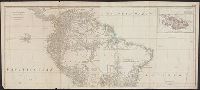
BEIN 2003 Folio 85: No. 4 of 45 maps bound together with binder's spine title: Atlas of America; ms. table of contents. Bookplate of Paul Mellon., by Eman. Bowen, geogr. to His Majesty, and John Gibson, engraver., Hand-colored., Includes text and insets of A particular map of Baffin and Hudson's Bay and The passage by land to California, discovered by Father Eusebius Francis Kino ...., Relief shown pictorially., Scale [ca. 1:5,500,000]., and Shows boundaries, cities and towns, roads, forts, missions, some industries, trails, trade routes, portages, and vegetation. Also shows Indian villages and tribal territories, routes of navigation in the Gulf of Mexico, and navigational hazards along the coast.
Publisher:
Printed for Robt. Sayer opposite Fetter Lane Fleet Street
Anville, Jean Baptiste Bourguignon d', 1697-1782 Cook, James, 1728-1779 Kitchin, Thomas, d. 1784, creator Sayer, Robert, 1725-1794
Published / Created:
1787 January 6
Call Number:
1982 Folio 10
Image Count:
2
Description:
Also appeared in Kitchin's General atlas describing the whole universe. London : Printed for Robert Sayer, [1780]., No. 29 of 43 maps bound together in composite atlas., Relief shown pictorially., Scale [ca. 1:11,100,000]., Sheets mounted together to form 2 sheets., Shows boundaries, rivers, settlements, islands; includes descriptive notes., and Title cartouche depicts local produce, a palm tree and a camel.
Kitchin, Thomas, d. 1784, creator Sayer, Robert, 1725-1794
Published / Created:
1787 January 1
Call Number:
1982 Folio 10
Image Count:
2
Description:
Also appeared in Kitchin's General atlas, describing the whole universe. London : Printed and sold for R. Sayer and J. Bennet, 1780., By Thos. Kitchin, hydrographer to the king ; with many additions and improvements from the latest surveys and observations., No. 4 of 43 maps bound together in composite atlas., Pictorial relief., Scale [ca. 1:4,800,000]., and Western part of the northern states including the British Islands, Norway, Denmark and part of Sweden -- Eastern part of the northern states, including the eastern part of Sweden; European Russia, &c. -- Western part of the Mediterranean Sea with the coasts of Spain, France, Italy, Barbary -- Eastern part of the Mediterranean Sea with the coasts of Turky [sic], Anatolia, Syria, Egypt and Barbary.
Publisher:
Robert Sayer
Subject (Geographic):
Africa, North --Maps --Early works to 1800, Europe --Maps --Early works to 1800, and Middle east --Maps --Early works to 1800
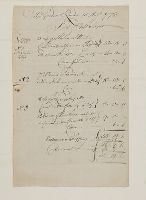
A manuscript invoice issued by Robert Sayer, a successful London print, map, and chart publisher, on 15 August 1772. The purchaser is one "Mr. Gordon" of "9 Bury Court, St. Mary Ave". The list is grouped by type, "10 historical prints", "72 prints of ladies, eminent men, humourous, etc.", "8 large landskips", and "12 views of Havannah", with details concerning framing, glass, cases, and shipping charges. On the verso, a docket title indicating a discount persumably because of the size of the order
Description:
Title supplied by cataloger., In English., and For further information, consult library staff.