Collins, H. G. (Henry George) Stanford, Edward, 1827-1904
Published / Created:
[1877?].
Call Number:
32 L84 1877
Container / Volume:
BRBL_00051
Image Count:
1
Resource Type:
Maps, Atlases & Globes
Description:
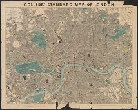
"This map is divided into squar, 32 L84 1877: Imperfect: mutilated with loss of text., and Map of London showing streets, parks, public buildings, postal boundaries, postal districts, railways in operation, railways under construction and tramways in operation.
Publisher:
Edward Stanford, 55 Charing Cross,
Subject (Geographic):
London (England)--Maps
Subject (Topic):
Railroads--England--London--Maps and Roads--England--London--Maps
"This map is also frequently to be seen mounted as one sheet with a wide border pasted around its outside limits ... The map shows ... the boundaries of the counties, county court dist and In portfolio with index map/characteristic sheet pasted to front flap.
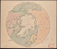
Boundaries; limits of drift ice; pack ice; tree line; names of the chief "Arctic Worthies" and the dates of discovery marked in red. and Mounted on linen. Autographs of William H. Brewer on recto and verso. Title in manuscript on verso. Stamps and label of Library of the Department of Geology, Yale University.
Publisher:
Published by Edward Stanford, 55 Charing Cross
Subject (Geographic):
Arctic regions--Discovery and exploration--Maps., Arctic regions--Maps., and Northern Hemisphere--Maps.