Skip to search
Skip to main content
Skip to first result
Search
You Searched For
Extent of Digitization
Completely digitized
Format
cartographic
Language
English
Creator
United States. General Land Office
New Search
Search Results
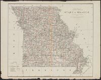
Creator:
Published / Created:
1878
Call Number:
816 1878
Container / Volume:
BRBL_00561
Image Count:
1
Resource Type:
Maps, Atlases & Globes
Publisher:
General Land Office,
Subject (Geographic):
Missouri--Maps
Subject (Name):
Bien, Julius, 1826-1909
Found in:
Beinecke Rare Book and Manuscript Library > State of Missouri : 1878.
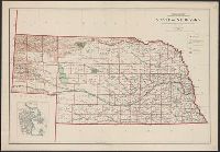
Creator:
Published / Created:
1908
Call Number:
824 1908
Container / Volume:
BRBL_00570
Image Count:
1
Resource Type:
Maps, Atlases & Globes
Description:
Includes inset of "City of Omaha.", Relief shown by shading., and Shows railroads, national forests, and military and Indian reservations.
Publisher:
Andrew B. Graham Company, lithographers,
Subject (Geographic):
Nebraska--Maps
Subject (Name):
Bauman, Wm. (William), Berthrong, I. P, and Dinsmore, A. F
Found in:
Beinecke Rare Book and Manuscript Library > State of Nebraska / Department of the Interior, General Land Office ; compiled from the official records of the General Land Office and other sources under the direction of I.P. Berthrong ; compiled by A.F. Dinsmore ; traced and lettered by Wm. Bauman, Jr
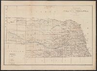
Creator:
Published / Created:
1879
Call Number:
824 1879
Container / Volume:
BRBL_00570
Image Count:
1
Resource Type:
Maps, Atlases & Globes
Description:
Department of the interior, J. A. Williamson, commissioner. and Shows railroads, Indian reservations, and military reservations.
Publisher:
Julius Bien,
Subject (Geographic):
Nebraska--Maps
Subject (Name):
Roeser, C. (Charles)
Found in:
Beinecke Rare Book and Manuscript Library > State of Nebraska / compiled from the official records of the General Land Office and other sources by C. Roeser.
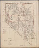
Creator:
Published / Created:
1879
Call Number:
837 1879
Container / Volume:
BRBL_00594
Image Count:
1
Resource Type:
Maps, Atlases & Globes
Description:
"J.S. Williamson, Commissioner.", Prime meridans: Greenwich and Washington., Relief shown by hachures., and Shows drainage, county boundaries, railroads, military & Indian reservations, townships, etc.
Publisher:
General Land Office,
Subject (Geographic):
Nevada--Maps and Nevada--Surveys--Maps
Subject (Name):
Bien, Julius, 1826-1909 and Roeser, C. (Charles)
Found in:
Beinecke Rare Book and Manuscript Library > State of Nevada / compiled from the official records of the General Land Office and other sources by C. Roeser, Principal Draughtsman, G.L.O.
Creator:
Published / Created:
1914
Call Number:
837 1914A
Container / Volume:
BRBL_00594
Image Count:
1
Resource Type:
Maps, Atlases & Globes
Description:
Includes 7 insets of cities. and Relief shown by shading and spot heights.
Publisher:
General Land Office,
Subject (Geographic):
Nevada--Maps
Subject (Name):
Berthrong, I. P
Found in:
Beinecke Rare Book and Manuscript Library > State of Nevada / compiled from the official records of the General Land Office and other sources under the direction of I.P. Berthrong.
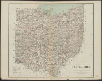
Creator:
Published / Created:
1878
Call Number:
804 1878
Container / Volume:
BRBL_00543
Image Count:
1
Resource Type:
Maps, Atlases & Globes
Description:
"J. A. Williamson, Commissioner." and Shows county boundaries, towns and railroads.
Publisher:
General Land Office.,
Subject (Geographic):
Ohio--Maps
Subject (Name):
Julius Bien & Co
Found in:
Beinecke Rare Book and Manuscript Library > State of Ohio / compiled from the official records of the Department of the Interior, General Land Office by C. Roeser, Principal Draughtsman.
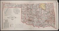
Creator:
Published / Created:
1907
Call Number:
827 1907
Container / Volume:
BRBL_00577
Image Count:
1
Resource Type:
Maps, Atlases & Globes
Description:
Includes insets of Guthrie, Muskogee, McAlester, and Lawton., Prime meridians: Washington and Greenwich., Relief shown by shading., and Shows counties and Indian, military, forest, and "public purpose" reserves.
Publisher:
General Land Office?],
Subject (Geographic):
Oklahoma--Maps
Subject (Name):
Berthrong, I. P, Dinsmore, A. F, Helm, Charles J, and Hendges, M
Found in:
Beinecke Rare Book and Manuscript Library > State of Oklahoma / compiled from the official records of the General Land Office and other sources under the direction of I.P. Berthrong ; compiled by A.F. Dinsmore and M. Hendges ; drawn by Charles J. Helm.
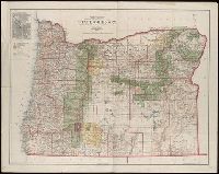
Creator:
Published / Created:
1879
Call Number:
846 1879A
Container / Volume:
BRBL_00621
Image Count:
1
Resource Type:
Maps, Atlases & Globes
Description:
"J.A. Williamson, Commissioner.", Gives longitude west from Washington and Greenwich., and Relief shown by hachures.
Publisher:
The Office],
Subject (Geographic):
Oregon--Maps
Subject (Name):
Bien, Julius, 1826-1909 and Roeser, C. (Charles)
Found in:
Beinecke Rare Book and Manuscript Library > State of Oregon / compiled from the official Records of the General Land Office and other sources by C. Roeser, Principal Draughtsman, General Land Office, Department of the Interior.
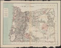
Creator:
Published / Created:
1906
Call Number:
846 1906
Container / Volume:
BRBL_00621
Image Count:
1
Resource Type:
Maps, Atlases & Globes
Abstract:
Shows county boundaries, military and Indian reservations, forest reserves, national parks, military roads, and lighthouses.
Description:
Gives longitude west from Greenwich and Washington, D.C., Inset: City of Portland., and Relief shown by shading.
Publisher:
The Office,
Subject (Geographic):
Oregon--Maps
Subject (Name):
Andrew B. Graham Co, Bauman, Wm. (William), Bond, Frank, 1856-1940, Dinsmore, A. F, and Hendges, M
Found in:
Beinecke Rare Book and Manuscript Library > State of Oregon / compiled from the official records of the General Land Office and other sources under the direction of Frank Bond ; compiled by M. Hendges ; revised by A.F. Dinsmore ; traced and lettered by Wm. Bauman Jr.
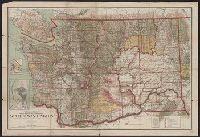
Creator:
Published / Created:
1909
Call Number:
847 1909
Container / Volume:
BRBL_00625
Image Count:
1
Resource Type:
Maps, Atlases & Globes
Description:
Also shows public lands., Includes township diagr. and insets of "Tacoma" and "Seattle.", and Relief shown by shading, hachures, and spot heights.
Publisher:
The Office,
Subject (Geographic):
Washington (State)--Maps
Subject (Name):
O'Hare, Daniel
Subject (Topic):
Public lands--Washington (State)--Maps
Found in:
Beinecke Rare Book and Manuscript Library > State of Washington / compiled from the official records of the General Land Office and other sources under the direction of I. P. Berthrong, chief of Drafting Division, G.L.O. ; compiled and drawn by Daniel O'Hare ; lettering by Wm Bauman, jr.
Branch:v1.61.6 ,Deployed:2024-06-12T09:55:36-04:00