Skip to search
Skip to main content
Skip to first result
Search
You Searched For
Extent of Digitization
Completely digitized
Access
Public
Format
cartographic
Creator
United States. General Land Office
Subject (Name)
Bien, Julius, 1826-1909
New Search
Search Results
Creator:
Published / Created:
1866
Call Number:
844fcm 1866
Container / Volume:
BRBL_00615
Image Count:
1
Resource Type:
Maps, Atlases & Globes
Alternative Title:
House executive document (United States. Congress. House) ; 38th Congress, 1st session, no. 1.
Description:
"House R. Ex. Doc. No. 1, 38th Cong., 1st Sess.", Includes "List of private grants finally surveyed.", Relief shown by hachures., and Shows drainage, townships, railroads, mines, oil springs, land grants, etc.
Publisher:
Department of the Interior, General Land Office,
Subject (Geographic):
California--Maps and California--Surveys--Maps
Subject (Name):
Bien, Julius, 1826-1909
Subject (Topic):
Land grants--California--Maps and Mines and mineral resources--California--Maps
Found in:
Beinecke Rare Book and Manuscript Library > Map of public surveys in California & Nevada : to accompany report of Commissioner of the General Land Office, 1866.
Creator:
Published / Created:
1866
Call Number:
75 1866
Container / Volume:
BRBL_00403
Image Count:
1
Resource Type:
Maps, Atlases & Globes
Description:
Also shows mine and mineral resources and Surveyor General and Land Office locations., Colored in outline., Includes notes., Prime meridians: Washington, D.C. and Greenwich., and Relief shown by hachures.
Publisher:
General Land Office,
Subject (Geographic):
United States--Surveys--Maps
Subject (Name):
Bien, Julius, 1826-1909 and Franks, Theodore
Subject (Topic):
Mines and mineral resources--United States--Maps
Found in:
Beinecke Rare Book and Manuscript Library > Map of the United States and territories : shewing the extent of public surveys and other details / constructed from the plats and official sources of the General Land Office, under the direction of Hon. Jos. S. Wilson, Commissioner, by Theodore Franks, d
Creator:
Published / Created:
1876
Call Number:
75 1876
Container / Volume:
BRBL_00405
Image Count:
6
Resource Type:
Maps, Atlases & Globes
Description:
Insets: Alaska and Aleutian Islands. and Relief shown by hachures.
Publisher:
Photolith. and printed by J. Bien,
Subject (Name):
Bien, Julius, 1826-1909 and Roeser, C. (Charles)
Subject (Topic):
Canals--United States--Maps, Indian reservations--United States--Maps, Military reservations--United States--Maps, Railroad land grants--United States--Maps, Railroads--United States--Maps, and Surveying-
Found in:
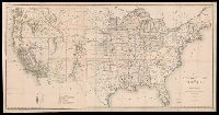
Beinecke Rare Book and Manuscript Library > Map of the United States and territories, showing the extent of public surveys, Indian and military reservations, land grant R.R., rail roads, canals, and other details / compiled from the official surveys of the General Land Office, and other authentic s
Creator:
Published / Created:
1878
Call Number:
818 1878
Container / Volume:
BRBL_00565
Image Count:
1
Resource Type:
Maps, Atlases & Globes
Description:
"J. A. Williamson, Commissioner"., Gives longitude west from Washington and Greenwich., and Relief shown by hachures.
Publisher:
General Land Office.,
Subject (Geographic):
Arkansas--Maps
Subject (Name):
Bien, Julius, 1826-1909 and Roeser, C. (Charles)
Found in:
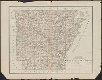
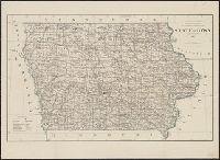
Beinecke Rare Book and Manuscript Library > State of Arkansas / compiled from the official records of the General Land Office and other sources by C. Roeser, Principal Draughtsman, GLO, Department of the Interior.
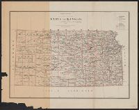
Creator:
Published / Created:
1878
Call Number:
815 1878
Container / Volume:
BRBL_00560
Image Count:
1
Resource Type:
Maps, Atlases & Globes
Description:
Prime meridians: Greenwich and Washington., Relief shown by hachures., and Shows county boundaries, towns and railroads.
Publisher:
General Land Office,
Subject (Geographic):
Iowa--Maps
Subject (Name):
Bien, Julius, 1826-1909 and Roeser, C. (Charles)
Found in:
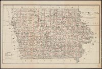
Beinecke Rare Book and Manuscript Library > State of Iowa / Department of the Interior, General Land Office, J.A. Williamson, Commissioner ; compiled from the official records of the General Land Office and other sources by C. Roeser, Principal Draughtsman, G.L.O.
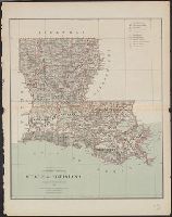
Creator:
Published / Created:
1879
Call Number:
795 1879
Container / Volume:
BRBL_00521
Image Count:
1
Resource Type:
Maps, Atlases & Globes
Description:
"J.A. Williamson, Commissioner.", Prime meridians: Washington and Greenwich., and Shows county boundaries and county seats, private grants, etc.
Publisher:
The Office,
Subject (Geographic):
Louisiana--Maps
Subject (Name):
Bien, Julius, 1826-1909 and Roeser, C. (Charles)
Found in:
Beinecke Rare Book and Manuscript Library > State of Louisiana / compiled from the official records of the General Land Office and other sources by C. Roeser, Principal Draughtsman, G.L.O.
Branch:v1.61.6 ,Deployed:2024-06-12T09:55:31-04:00