Skip to search
Skip to main content
Skip to first result
Search
You Searched For
Format
cartographic
Creator
United States. General Land Office
Search Results
Creator:
Published / Created:
1866
Call Number:
815fcm 1866
Container / Volume:
BRBL_00561
Image Count:
1
Resource Type:
Maps, Atlases & Globes
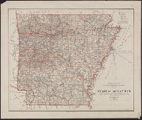
Description:
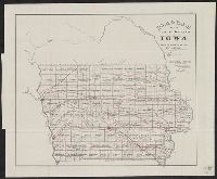
"No. 7."
Publisher:
U.S. General Land Office,
Subject (Geographic):
Iowa--Maps
Subject (Topic):
Mines and mineral resources--Iowa--Maps and Railroads--Iowa--Maps
Found in:
Beinecke Rare Book and Manuscript Library > Diagram of the public surveys in Iowa.
Creator:
Published / Created:
1866
Call Number:
844fcm 1866
Container / Volume:
BRBL_00615
Image Count:
1
Resource Type:
Maps, Atlases & Globes
Alternative Title:
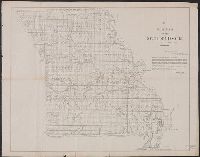
House executive document (United States. Congress. House) ; 38th Congress, 1st session, no. 1.
Description:
"House R. Ex. Doc. No. 1, 38th Cong., 1st Sess."
Publisher:
Department of the Interior, General Land Office,
Subject (Geographic):
California--Maps and California--Surveys--Maps
Subject (Name):
Bien, Julius, 1826-1909
Subject (Topic):
Land grants--California--Maps and Mines and mineral resources--California--Maps
Found in:
Beinecke Rare Book and Manuscript Library > Map of public surveys in California & Nevada : to accompany report of Commissioner of the General Land Office, 1866.
Creator:
Published / Created:
1864
Call Number:
75fcm 1864
Container / Volume:
BRBL_00410
Image Count:
1
Resource Type:
Maps, Atlases & Globes
Description:
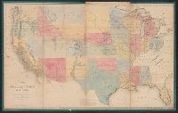
Relief shown by hachures.
Publisher:
D. McClelland,
Subject (Geographic):
Canada--Boundaries--United States--Maps
Subject (Name):
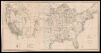
Franks, Theodore, Hawes, James W. (James William), 1844-1918, and McClelland, D
Subject (Topic):
Public lands --United States and Public lands--United States--Maps.
Found in:
Beinecke Rare Book and Manuscript Library > Map of the Public Land States and territories [cartographic material] / constructed from the Public Surveys and other official sources in the General Land Office ; drawn by J.H. Hawes, principal draughtsman [and] T. Franks, assistant.
Creator:
Published / Created:
1876
Call Number:
75 1876
Container / Volume:
BRBL_00405
Image Count:
6
Resource Type:
Maps, Atlases & Globes
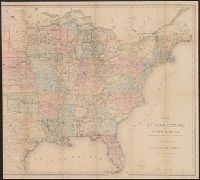
Description:
Insets: Alaska and Aleutian Islands.
Publisher:
Photolith. and printed by J. Bien,
Subject (Name):
Bien, Julius, 1826-1909 and Roeser, C. (Charles)
Subject (Topic):
Canals--United States--Maps, Indian reservations--United States--Maps, Military reservations--United States--Maps, Railroad land grants--United States--Maps, Railroads--United States--Maps, and Surveying-
Found in:
Beinecke Rare Book and Manuscript Library > Map of the United States and territories, showing the extent of public surveys, Indian and military reservations, land grant R.R., rail roads, canals, and other details / compiled from the official surveys of the General Land Office, and other authentic s