Search
You Searched For
Search Results
- Creator:
- United States. General Land Office
- Published / Created:
- 1866
- Call Number:
- 825fcm 1866
- Container / Volume:
- BRBL_00575
- Image Count:
- 1
- Resource Type:
- Maps, Atlases & Globes
- Alternative Title:
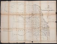
- (12) map showing the progress of the public surveys in Kansas and Nebraska
- Description:
- Also shows coal, salt, lead, platina, and marble deposits.
- Publisher:
- s.n.],
- Subject (Geographic):
- Kansas--Maps and Nebraska--Maps
- Subject (Name):
- United States. General Land Office. Maps accompanying report of the commissioner of the General Land Office
- Subject (Topic):
- Public lands--Kansas--Maps and Public lands--Nebraska--Maps
- Found in:
- Beinecke Rare Book and Manuscript Library > Map showing the progress of the public surveys in Kansas and Nebraska / Surveyor General's Office ; Department of the Interior, General Land Office, Oct. 2nd, 1866.
- Creator:
- United States. General Land Office
- Published / Created:
- 1866
- Call Number:
- 825fcm 1866
- Container / Volume:
- BRBL_00575
- Image Count:
- 1
- Resource Type:
- Maps, Atlases & Globes
- Alternative Title:
- (12) map showing the progress of the public surveys in Kansas and Nebraska
- Description:
- Also shows coal, salt, lead, platina, and marble deposits.
- Publisher:
- s.n.],
- Subject (Geographic):
- Kansas--Maps and Nebraska--Maps
- Subject (Name):
- United States. General Land Office. Maps accompanying report of the commissioner of the General Land Office
- Subject (Topic):
- Public lands--Kansas--Maps and Public lands--Nebraska--Maps
- Found in:
- Beinecke Rare Book and Manuscript Library > Map showing the progress of the public surveys in Kansas and Nebraska / Surveyor General's Office ; Department of the Interior, General Land Office, Oct. 2nd, 1866.
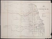
- Creator:
- United States. Surveyor General
- Published / Created:
- 1862?]
- Call Number:
- 825fcm 1862
- Container / Volume:
- BRBL_00575
- Image Count:
- 1
- Resource Type:
- Maps, Atlases & Globes
- Alternative Title:
- House executive document (United States. Congress. House) ; 37th Congress, 3rd session, no. 1.
- Description:
- "House Ex. Doc. no. 1, 37th. Cong., 3d. Sess." [Serial set v. 1160]
- Publisher:
- s.n.,
- Subject (Geographic):
- Kansas--Maps and Nebraska--Maps
- Subject (Topic):
- Public lands--Kansas--Maps and Public lands--Nebraska--Maps
- Found in:
- Beinecke Rare Book and Manuscript Library > Map showing the progress of the public surveys in Kansas and Nebraska : to accompany annual report of the Surveyor General, 1862 / Surveyor General's Office, Leavenworth, Kansas.
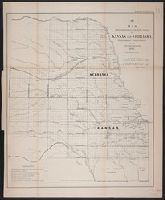
- Creator:
- United States. General Land Office
- Published / Created:
- 1860?
- Call Number:
- 825fcm 1860
- Container / Volume:
- BRBL_00575
- Image Count:
- 1
- Resource Type:
- Maps, Atlases & Globes
- Alternative Title:
- Senate executive document (United States. Congress. Senate) ; 36th Congress, 2nd session, no. 1.
- Description:
- "Sen. ex. doc. no. 1, 2d sess. 36th Cong."
- Publisher:
- s.n.],
- Subject (Geographic):
- Kansas--Maps and Nebraska--Maps
- Subject (Topic):
- Public lands--Kansas--Maps and Public lands--Nebraska--Maps
- Found in:
- Beinecke Rare Book and Manuscript Library > Map showing the progress of the public surveys in the territories of Kansas and Nebraska : to accompany annual report of the Surveyor General, 1860.