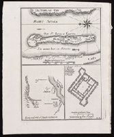
[Top] Chart of the island of Saint Louis showing location of the Fort St. Louis, the reservoir, and dwellings in western Africa; [bottom left] Chart of the location of Fort St. Joseph in Bakel, Senegal, on the Senegal River; [bottom right] Plan of the Fort St. Joseph.
Alternative Title:
Egnen fra fortet St. Joseph til Galam and Grundridsning of fortet St. Joseph
Description:
"No. 14" in upper right corner; "III.D." in lower right corner., Coordinates not present on map and are approximated., From Almindelig histoirie over reiser til lands og bands ... (Kjøbenhavn: Niels Hansen Møller, 1749), a translation of Collection of voyages and travels edited by Awnsham Chruchill and Thomas Osborne., North oriented towards the left on first map., Relief shown pictorially., and Title of first map devised by cataloger.
Publisher:
[Niels Hansen Møller],
Subject (Geographic):
Bakel (Senegal : Department)--Maps--Early works to 1800. and Saint-Louis (Senegal)--Maps--Early works to 1800.
Subject (Name):
Churchill, Awnsham, -1728. Collection of voyages and travels. Danish., Møller, Niels Hansen, and Osborne, Thomas, -1767. Collection of voyages and travels. Danish.
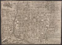
The military tract comprised 28 townships (1,680,000 acres) in New York State that was granted to soldiers of the War of American Revolution. This land included all or parts of present day Cayuga, Cortland, Onondaga, Oswego, Schuyler, Seneca, Tompkins, and Wayne counties. The names of the towns were given classical Greek and Roman names along a few honoring English authors.
Description:
Heavily annotated throughout by Elkanah Watson., Maps most likely date from 1793 to 1794., and Title devised by cataloger.
Subject (Geographic):
New York (State)--Maps--Early works to 1800. and New York (State)--Surveys--Early works to 1800.
Subject (Name):
Watson, Elkanah,--1758-1842--Ms. notes.
Subject (Topic):
Land subdivision--New York (State)--Early works to 1800.
An issue of the Pownall map of North America and the West Indies; appears similar to the 1783 and 1794 editions., Insets: A particular map of Baffin and Hudson's Bay -- The passage by land to California., Prime meridians: London and Ferro., and Relief shown pict
American N.W. Coast is not continued (except in a dotted line) North of California, and no mention is made of Bering's discoveries. and Preliminary record.