Search
You Searched For
Search Results
- Creator:
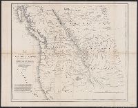
- Hood, Washington
- Published / Created:
- 1838]
- Call Number:
- 80 1838B
- Container / Volume:
- BRBL_00532
- Image Count:
- 1
- Resource Type:
- Maps, Atlases & Globes
- Found in:
- Beinecke Rare Book and Manuscript Library > Map of the United States, Territory of Oregon, west of the Rocky Mountains : exhibiting the various trading depots or forts occupied by the British Hudson Bay Company, connected with the western and northwestern fur trade / compiled in the Bureau of Topog
- Creator:
- St. Mary's Canal Mineral Land Company
- Published / Created:
- [1859]
- Call Number:
- BrSides Folio 2018 137
- Image Count:
- 1
- Resource Type:
- Maps, Atlases & Globes
- Found in:
- Beinecke Rare Book and Manuscript Library > Map showing iron mines in vicinity of Marquette, Lake Superior [cartographic material].
- Creator:
- Darley, George, 1795-1846
- Published / Created:
- 1835
- Call Number:
- In D249 835
- Image Count:
- 43
- Resource Type:
- Books, Journals & Pamphlets
- Found in:
- Beinecke Rare Book and Manuscript Library > Nepenthe / by George Darley.
- Creator:
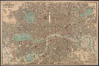
- Reynolds, James, active 1845-1864
- Published / Created:
- 1871
- Call Number:
- 32 L84 1871
- Container / Volume:
- BRBL_00051
- Image Count:
- 1
- Resource Type:
- Maps, Atlases & Globes
- Found in:
- Beinecke Rare Book and Manuscript Library > New map of London with the recent improvements : divided into quarter mile sections for measuring distances.
- Creator:
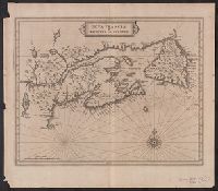
- Laet, Joannes de, 1581-1649
- Published / Created:
- 1630]
- Call Number:
- 73 1720
- Container / Volume:
- BRBL_00688
- Image Count:
- 1
- Resource Type:
- Maps, Atlases & Globes
- Found in:
- Beinecke Rare Book and Manuscript Library > Nova Francia et regiones adiacentes [cartographic material].
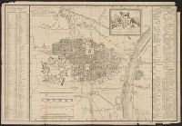
- Creator:
- Conti, Giuseppe, cartographer
- Published / Created:
- 1817
- Call Number:
- 40 T729 1809
- Image Count:
- 1
- Resource Type:
- Maps, Atlases & Globes
- Found in:
- Beinecke Rare Book and Manuscript Library > Pianta della città di Torino / designata dall'ing. top. Giuseppe Conti.
- Creator:
- Dezauche, J. A
- Published / Created:
- [between 1816 and 1824]
- Call Number:
- 682 1824
- Container / Volume:
- BRBL_00350
- Image Count:
- 1
- Resource Type:
- Maps, Atlases & Globes
- Found in:
- Beinecke Rare Book and Manuscript Library > Plan d'Alger et des environs [cartographic material] / dressé d'après plusieurs plans manuscrits par J.A. Dezauche ; atelier de A. Desmadryl ; Imorimé par Engelman.
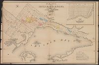
- Creator:
- Savigny, Hugh P
- Published / Created:
- [1870]
- Call Number:
- BrSides Double Folio 2018 101
- Image Count:
- 1
- Resource Type:
- Maps, Atlases & Globes
- Found in:
- Beinecke Rare Book and Manuscript Library > Plan of survey of the silver mining district, Thunder Bay, Lake Superior, Canada / compiled by Hugh P. Savigny, P.L.S.
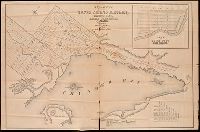
- Creator:
- Savigny, Hugh P.
- Published / Created:
- [1870]
- Call Number:
- 8075gfc 1870
- Container / Volume:
- BRBL_00551
- Image Count:
- 1
- Resource Type:
- Maps, Atlases & Globes
- Found in:
- Beinecke Rare Book and Manuscript Library > Plan of survey of the silver mining district, Thunder Bay, Lake Superior, Canada / compiled by Hugh P. Savigny, P.L.S.
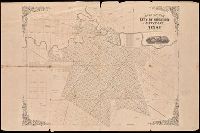
- Published / Created:
- [1858?]
- Call Number:
- 796 H818 1858
- Image Count:
- 1
- Resource Type:
- Maps, Atlases & Globes
- Found in:
- Beinecke Rare Book and Manuscript Library > Plan of the city of Houston and environs, Texas / drawn by E.F. Gray.