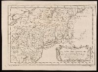
"Tom. XIV. in 4°, no. 9. Tome 14. in 8°, page 97." in lower margin., Appears in Jean François de La Harpe's Abrégé de l'histoire générale des voyages. 1780., Covers the area from Penobscot Bay to Chesapeake Bay and west to Lake Erie., Prime meridian: Paris., Relief shown pictorially., Shows provices, towns, forts, rivers, Indian tribal territory, and relief., and Watermark.
Publisher:
[publisher not identified],
Subject (Geographic):
NewEngland--Maps--Early works to 1800.
Subject (Name):
La Harpe, Jean-François de, 1739-1803. Abrégé de l'histoire générale des voyages.
Printed for Robt. Sayer & John Bennett, sea chart & map-sellers, No. 53, in Fleet Street. Published as the Act directs,
Subject (Geographic):
Atlantic Ocean--Lower Bay, Atlantic Ocean--Upper Bay, New Jersey--Sandy Hook, New York Harbor (N.Y. and N.J.) Maps--Early works to 1800., New York Region--Maps--Early works to 1800., and Sandy Hook (N.J.)
Subject (Name):
Robert Sayer and John Bennett (Firm), printmaker, printseller
Subject (Topic):
Nautical charts, Nautical charts--Hudson River Estuary (N.Y. and N.J.)--Early works to 1800., Nautical charts--Lower Bay (N.Y. and N.J.)--Early works to 1800., and Nautical charts--Upper Bay (N.Y. and N.J.)--Early works to 180