Description of the Canary Islands, including the modern history of the inhabitants, and an account of their manners, customs, trade, &c. and Historia de la conquista de las siete islas de Gran Canaria. English
Description:
Imperfect: all but title page, pages 1-2, and leaves of plates wanting. Stamps on title page: American Geographical and Statistical Socy.; duplicate copy sold.
Publisher:
Printed for R. and J. Dodsley in Pall-mall, and T. Durham in the Strand,
Subject (Geographic):
Canary Islands--Description and travel--Early works to 1800 and Canary Islands--History--Early works to 1800
Subject (Name):
American Geographical and Statistical Society Stamp, Dodsley, James, 1724-1797, Dodsley, Robert, 1704-1764, Durham, Thomas (Bookseller), and Glas, Ge
Cuba with part of the Bahama banks & the Martyrs and The North American pilot.
Description:
From: The North American pilot. London, 1778-1779. Vol. 2, no. 13., Imperfect: chipped and torn, with no loss of text. Joined with Jeffrey's Coast of Yucatán from Campeche to Baha del Ascencion, with the west end of Cuba., Prime meridians: Ferro and London., Relief shown pictorially. Depths shown by soundings and shading., and Shows towns and roads in Cuba (except easternmost and westernmost parts) and part of Bahamas and Florida Keys.
Publisher:
Printed for Robt. Sayer,
Subject (Geographic):
Bahamas--Maps--Early works to 1800, Cuba--Maps--Early works to 1800, and Florida Keys (Fla.)--Maps--Early works to 1800
Decorated with sea monsters, mermaids, exotic animals, and cannibals, this wood cut map provides a marked contrast to the simplistic diagrams considered the earliest printed world maps. While the latter presented a world view based in Judeo-Christian theo
Alternative Title:
Typus cosmographicus universalis and Typvs cosmographicvs vniversalis
Description:
Appears in Johann Huttich's Novus orbis regionum. Basel. 1532. and Relief shown pictorially.
Publisher:
[publisher not identified],
Subject (Name):
Holbein, Hans, 1497-1543 and Huttich, Johann, 1480?-1544. Novus orbis regionum.
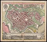
Breslau die uhralte u[nd] hochberühmte Haupt Statt des Herzogth. Schlesien auch vortrefflicher aufenthalt der Musen u[nd] florisanter Handels Plaz an dem Oder Strom
Description:
"Cum gratia et privil. S.R.I. Vicariat[us] in partib[us] Rheni, Svevice, et Juris Franconici.", Ancillary view: Breslaw. Not drawn to scale., Buildings shown pictorially., Includes index, text, and illustrations., Latin and German., and Manuscript notation in upper right corner. From the Karpinski-von Wieser Map Collection.
Publisher:
[Matthaeus Seutter]
Subject (Geographic):
Poland--Wrocław, Wrocław (Poland)--Aerial views--Early works to 1800., and Wrocław (Poland)--Maps--Early works to 1800.
"Photolithographed copy of Gerard Mercator's Mapamundi of 1538 from an original engraving in the library of the American Geographical Society.", Relief shown pictorially., and Title devised by cataloger.
Publisher:
Julius Bien & Co., photo-lith,
Subject (Geographic):
World--Maps--Early works to 1800
Subject (Name):
American Geographical Society of New York and Julius Bien & Co
Subject (Topic):
Early maps, Early maps--Facsimiles, World maps, and World maps--Early works to 1800