Skip to search
Skip to main content
Skip to first result
Search
You Searched For
Extent of Digitization
Completely digitized
Genre
Manuscript maps
Resource Type
Maps, Atlases & Globes
Language
English
New Search
Search Results
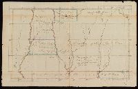
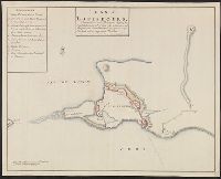
Published / Created:
[1791]
Call Number:
BrSides 2017 122
Image Count:
2
Resource Type:
Maps, Atlases & Globes
Description:
Coordinates not present on map and are approximated., From the Nathaniel Pendleton family papers., Prime meridians: Philadelphia and London., Shows lands of the Cherokee, Creek, and Chickasaw Indian tribes. Also shows lands designated for the Tennessee, South-Carolina Yazoo, and Virginia Yazoo Companies., Title from verso of map., and Watermark.
Subject (Geographic):
Chickasaw Nation--Maps--Early works to 1800., Choctaw Nation--Maps--Early works to 1800., Creek Nation--Maps--Early works to 1800., and Mississippi--Maps--Early works to 1800.
Subject (Name):
Pendleton, Nathaniel,--1756-1821, South-Carolina Yazoo Company., Tennessee Company., and Virginia Yazoo Company.
Subject (Topic):
Public lands--Georgia--Early works to 1800., Real property--Mississippi--Maps--Early works to 1800., and Yazoo Fraud, 1795--Maps--Early works to 1800.
Found in:
Beinecke Rare Book and Manuscript Library > Map of the western territory, 1791.
Published / Created:
[between 1850 and 1859?]
Call Number:
BrSides 2018 156
Image Count:
1
Resource Type:
Maps, Atlases & Globes
Description:
From the Richard H. Rickard Papers., Shows mine locations in Madison County, Virginia., and Title from verso of sheet.
Subject (Name):
Rickard, Richard H.,---1885--Ownership.
Subject (Topic):
Copper mines and mining--Virginia--Madison County--Maps.
Found in:
Beinecke Rare Book and Manuscript Library > Map showing copper lands in Virginia.
Creator:
Published / Created:
2nd Feby. 1877.
Call Number:
BrSides Double Folio 2018 97
Image Count:
1
Resource Type:
Maps, Atlases & Globes
Description:
Coordinates not present on map and are approximated., From the Richard H. Rickard Papers., and Title devised by cataloger.
Publisher:
Department of Crown Lands,
Subject (Name):
Ontario. Department of Crown Lands. and Rickard, Richard H.,---1885--Ownership.
Subject (Topic):
Mines and mineral resources--Ontario--Thunder Bay Region--Maps. and Real property--Ontario--Thunder Bay Region--Maps.
Found in:
Beinecke Rare Book and Manuscript Library > McIntyre / Thos. H. Johnson, Assistant Commissioner.
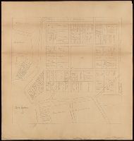
Call Number:
BrSides Double Folio 2017 26
Image Count:
1
Resource Type:
Maps, Atlases & Globes
Description:
Coordinates not present on map and are approximated., Inscription on verso: Mr. Day, 10 College St., and North oriented towards the upper right.
Subject (Geographic):
New Haven (Conn.)--Maps.
Found in:
Beinecke Rare Book and Manuscript Library > New Haven in 1641.
Published / Created:
1738
Call Number:
583 1738
Container / Volume:
BRBL_00707
Image Count:
1
Resource Type:
Maps, Atlases & Globes
Description:
Color: green, yellow. red detail.
Publisher:
Robt. Friund,
Subject (Geographic):
Malay Peninsula--Maps, Manuscript--Early works to 1800
Found in:
Beinecke Rare Book and Manuscript Library > Part of Malaya. Part of Tanasary.
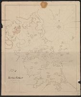
Published / Created:
[1804?]
Call Number:
764 B65 1804
Container / Volume:
BRBL_00710
Image Count:
1
Resource Type:
Maps, Atlases & Globes
Description:
Depths shown by soundings.
Subject (Geographic):
Boston Harbor (Mass.)--Maps
Found in:
Beinecke Rare Book and Manuscript Library > Plan of Boston Harbor, from actual survey.
Published / Created:
1753
Call Number:
764 G297 1753
Container / Volume:
BRBL_00710
Image Count:
1
Resource Type:
Maps, Atlases & Globes
Description:
Color: pen and ink drawing.
Subject (Geographic):
Massachusetts--Maps, Manuscript--Early works to 1800
Found in:
Beinecke Rare Book and Manuscript Library > Plan of George's Island [in Boston Harbor].
Published / Created:
[1800?]
Call Number:
399cea 1800
Container / Volume:
BRBL_00704
Image Count:
1
Resource Type:
Maps, Atlases & Globes
Description:
Color: Pen drawing. and Key in upper left hand corner.
Subject (Geographic):
Gibraltar--Maps, Manuscript--Early works to 1800
Found in:
Beinecke Rare Book and Manuscript Library > Plan of Gibraltar Bay.
Published / Created:
1745
Call Number:
7325 L93 1745
Container / Volume:
BRBL_00709
Image Count:
1
Resource Type:
Maps, Atlases & Globes
Description:
Color: blue, green and pink., Key in right hand corner., and Manuscript pluse negative photstat.
Subject (Geographic):
Louisbourg (N.S.)--Maps, Manuscript--Early works to 1800
Found in:
Beinecke Rare Book and Manuscript Library > Plan of Louisbourg. Surrendered to his Britanick Majesty by capitulation the 17th of June 1745 to Lieut. General Pepperel and Commodore Warren ... drawn on the spot by John Henry Bastide.
Creator:
Published / Created:
1776 August
Call Number:
BrSides Folio 2015 13
Image Count:
4
Resource Type:
Maps, Atlases & Globes
Abstract:
Original water color plan made by Col. John Trumbull in Fort Ticonderoga, August, 1776, by order of General George Washington and sent to Congress. It was accompanied by a memorial to Congress urging the abandonment of Fort Independence and the occupation of Mount Defiance.
Description:
Coordinates not present on map and are approximated. and Title devised by cataloger.
Subject (Geographic):
Independence, Mount (Vt.)--Maps--Early works to 1800. and Vermont--History--Revolution, 1775-1783--Maps--Early works to 1800.
Found in:
Beinecke Rare Book and Manuscript Library > Plan of Mount Independence.
Branch:v1.61.6 ,Deployed:2024-06-12T09:55:37-04:00