Skip to search
Skip to main content
Skip to first result
Search
You Searched For
Extent of Digitization
Completely digitized
Genre
Maps
Genre
World maps
Subject (Topic)
World maps
New Search
Search Results
Creator:
Published / Created:
1854]
Call Number:
11 1854
Container / Volume:
BRBL_00009
Image Count:
1
Resource Type:
Maps, Atlases & Globes
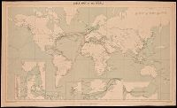
Description:
In lower right margin: Engd. by G. Aikman., Plate III-I from: General atlas of the world. Edinburgh : A. and C. Black, 1854., Prime meridian: Greenwich., and World map showing magnetic curves.
Publisher:
A. & C. Black,
Subject (Geographic):
World--maps
Subject (Topic):
Magnetic declination--Maps and World maps
Found in:
Beinecke Rare Book and Manuscript Library > A chart of magnetic curves of equal variation / by Peter Barlow.
Creator:
Published / Created:
1909
Call Number:
BrSides Double Folio 2018 95
Image Count:
1
Resource Type:
Maps, Atlases & Globes
Alternative Title:
G.S.G.S. ; No. 1849 and GSGS (Series) ; No. 1849
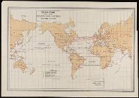
Description:
Backed with linen. and Includes grid, notes and 6 inset maps.
Publisher:
War Office,
Subject (Topic):
Cables, Submarine--Maps., Telegraph, Telegraph--Maps., and World maps
Found in:
Beinecke Rare Book and Manuscript Library > Cable map of the world [cartographic material].
Creator:
Published / Created:
[1899]
Call Number:
BrSides Folio 2019 64
Image Count:
1
Resource Type:
Maps, Atlases & Globes
Description:
Includes explanation key. and Shows generalized cable routes.
Publisher:
Norris Peters Co.,
Subject (Name):
Norris Peters Co.
Subject (Topic):
Cables, Submarine--Maps. and World maps
Found in:
Beinecke Rare Book and Manuscript Library > Submarine and land telegraph systems of the world [cartographic material].
Branch:v1.61.6 ,Deployed:2024-06-12T09:55:36-04:00