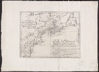
From The Gentleman's magazine and historical chronicle (November, 1776), vol. 46., Prime meridian: London., Relief shown pictorially., Sheet measures 21.2 x 25 cm. Cross Collection no. 199., and Shows Fairfield, New Haven, and New London counties in Connecticut, towns, roads, rivers, and place names in Connecticut, Rhode Island and part of Long Island. Includes copper mine near Simsbury, Conn. Also shows relief.
Publisher:
Gentleman's Magazine,
Subject (Geographic):
Connecticut--Maps--Early works to 1800, Long Island Sound (N.Y. and Conn.)--Maps--Early works to 1800, and Rhode Island--Maps--Early works to 1800
From The Gentleman's magazine and historical chronicle (November, 1776), vol. 46., Prime meridian: London., Relief shown pictorially., Sheet measures 22.2 x 26.3 cm. Cross Collection no. 200., and Shows Fairfield, New Haven, and New London counties in Connecticut, towns, roads, rivers, and place names in Connecticut, Rhode Island and part of Long Island. Includes copper mine near Simsbury, Conn. Also shows relief.
Publisher:
Gentleman's Magazine,
Subject (Geographic):
Connecticut--Maps--Early works to 1800, Long Island Sound (N.Y. and Conn.)--Maps--Early works to 1800, and Rhode Island--Maps--Early works to 1800
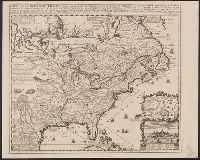
Although the map bears the date of 1755, it was not published until 1769., Dutch edition of Palairet's Carte des possessions angloises & francoises ... [1755]., From Isaak Tirion, and Hand col. Sheet measures 44 x 54 cm. Accompanied by ms. note by Henry Stevens.
Publisher:
By Isaak Tirion,
Subject (Geographic):
North America--Maps--Early works to 1800 and United States--History--French and Indian War, 1755-1763--Maps--Early works to 1800
Subject (Name):
Palairet, Jean, 1697-1774. Carte des possessions angloises & francoises du continent de l'Amerique Septentrionale
Subject (Topic):
British--America--Maps--Early works to 1800 and French--America--Maps--Early works to 1800
755 1755Z: Hand col. Sheet measures 44 x 54 cm., Although the map bears the date of 1755, it was not published until 1769., Dutch edition of Palairet's Carte des possessions angl, and Hand col. Sheet measures 44 x 54 cm. Accompanied by ms. note by Henry Stevens.
Publisher:
By Isaak Tirion,
Subject (Geographic):
North America--Maps--Early works to 1800 and United States--History--French and Indian War, 1755-1763--Maps--Early works to 1800
Subject (Name):
Palairet, Jean, 1697-1774. Carte des possessions angloises & francoises du continent de l'Amerique Septentrionale
Subject (Topic):
British--America--Maps--Early works to 1800 and French--America--Maps--Early works to 1800
From Robert Sayer and John Bennett's American military pocket atlas (1776)., Imperfect: torn at bottom middle along fold, with some loss of text. Manuscript number of vero: 3., Relief shown pictorially., and Watermark.
Subject (Geographic):
NewEngland--Maps--Early works to 1800
Subject (Name):
Holland, Samuel, 1728-1801, Pownall, Thomas, 1722-1805, and Robert Sayer and John Bennett (Firm). American military pocket atlas
Italian version of Carte d'une partie de l'Amérique Septentrionale pour servir á l'intelligence du mémoire, London, 1755, delineating the boundary dispute between France and England over Nova Scotia. Shows historical French claims in Acadia. and Watermark.
Publisher:
[publisher not identified],
Subject (Geographic):
NewEngland--Maps--Early works to 1800
Subject (Name):
Bellin, Jacques Nicolas, 1703-1772. Carte d'une partie de l'Amérique Septentrionale pour servir á l'intelligence du mémoire. Italian
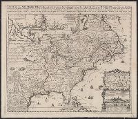
Appears in Chatelain's Atlas historique according to McCorkle., Cross collection no. 149., In upper right: Tom: VI. No: 23. Pag: 91., Includes notes, table of coordinates for certain locations, and ill., and Insets: Les environs de Quebec -- Veüe de Quebec -- Les costes de la Louisiane.
Publisher:
Chez L'Honoré & Châtelain Libraires?,
Subject (Geographic):
New France--Maps--Early works to 1800 and North America--Maps--Early works to 1800
Appears in Chatelain's Atlas historique according to McCorkle., Cross collection no. 149., In upper right: Tom: VI. No: 23. Pag: 91., Includes notes, table of coordinates for certain locations, and ill., McCorkle attributes authorshi, and Relief shown pictorially.
Publisher:
Chez L'Honoré & Châtelain Libraires?,
Subject (Geographic):
New France--Maps--Early works to 1800 and North America--Maps--Early works to 1800