Search
You Searched For
Search Results
- Published / Created:
- [1856]
- Call Number:
- 792 1855A
- Container / Volume:
- BRBL_00518
- Image Count:
- 1
- Resource Type:
- Maps, Atlases & Globes
- Found in:
- Beinecke Rare Book and Manuscript Library > A Plat exhibiting the state of the surveys in the State of Florida : with references Surveyor Generals Office St. Augustine Oct. 1855. Approved John Wescott Surveyor General
- Creator:
- United States. Hydrographic Office
- Published / Created:
- [1851?]
- Call Number:
- 74cea 1851
- Container / Volume:
- BRBL_00394
- Image Count:
- 1
- Resource Type:
- Maps, Atlases & Globes
- Found in:
- Beinecke Rare Book and Manuscript Library > A chart illustrative of the cruise of the American Arctic expedition in search of Sir John Franklin, in the years 1850 & 1851.
- Creator:
- Adam and Charles Black (Firm)
Aikman, George, engraver
Barlow, Peter, 1776-1862
- Published / Created:
- 1854]
- Call Number:
- 11 1854
- Container / Volume:
- BRBL_00009
- Image Count:
- 1
- Resource Type:
- Maps, Atlases & Globes
- Found in:
- Beinecke Rare Book and Manuscript Library > A chart of magnetic curves of equal variation / by Peter Barlow.
- Creator:
- Lucas, Fielding, 1781-1854
- Published / Created:
- c1852.
- Call Number:
- 778cea 1852
- Container / Volume:
- BRBL_00504A
- Image Count:
- 1
- Resource Type:
- Maps, Atlases & Globes
- Found in:
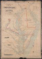
- Beinecke Rare Book and Manuscript Library > A chart of the Chesapeake and Delaware Bays / compiled and published by Fielding Lucas Junr.
- Creator:
- Lucas, Fielding, 1781-1854
Warr, John, b. ca. 1798
Warr, William W
- Published / Created:
- [1862], c1852
- Call Number:
- 21cea 1862
- Image Count:
- 1
- Resource Type:
- Maps, Atlases & Globes
- Found in:
- Beinecke Rare Book and Manuscript Library > A chart of the Chesapeake and Delaware Bays / compiled and published by Fielding Lucas.
- Creator:
- Cooke & LeCount
- Published / Created:
- 1852
- Call Number:
- Zc72 852co
- Image Count:
- 3
- Resource Type:
- Maps, Atlases & Globes
- Found in:
- Beinecke Rare Book and Manuscript Library > A complete map of San Francisco : compiled from the original map from the latest surveys, containing all the latest extensions and improvements, new streets, alleys, places, wharfs, etc
- Creator:
- Milleson, M
- Published / Created:
- 1851
- Call Number:
- 844 F313 1851
- Container / Volume:
- BRBL_00604
- Image Count:
- 1
- Resource Type:
- Maps, Atlases & Globes
- Found in:
- Beinecke Rare Book and Manuscript Library > A complete map of the Feather & Yuba Rivers [Calif.] : with towns, ranches, diggings, roads, distances / compiled from the recent surveys of M. Milleson & R. Adams, C. Engineers.
- Published / Created:
- 1852?]
- Call Number:
- 846 1852
- Container / Volume:
- BRBL_00620
- Image Count:
- 2
- Resource Type:
- Maps, Atlases & Globes
- Found in:
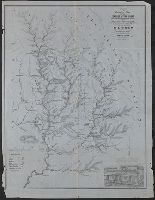
- Beinecke Rare Book and Manuscript Library > A diagram of a portion of Oregon Territory.
- Published / Created:
- 1852
- Call Number:
- 766 N46 1852B
- Container / Volume:
- BRBL_00470
- Image Count:
- 1
- Resource Type:
- Maps, Atlases & Globes
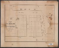
- Found in:
- Beinecke Rare Book and Manuscript Library > A map of 60 building lots in the city of New Haven belonging to C.T. Shelton, Esq.
- Published / Created:
- [1852?]
- Call Number:
- 327 1852
- Container / Volume:
- BRBL_00073
- Image Count:
- 1
- Resource Type:
- Maps, Atlases & Globes
- Found in:
- Beinecke Rare Book and Manuscript Library > A map of Ireland ... with the distances of the principal towns from Dublin ...