Skip to search
Skip to main content
Skip to first result
Search
You Searched For
Extent of Digitization
Completely digitized
Genre
World maps
Subject (Topic)
World maps
Search Results
Creator:
Published / Created:
1854]
Call Number:
11 1854
Container / Volume:
BRBL_00009
Image Count:
1
Resource Type:
Maps, Atlases & Globes
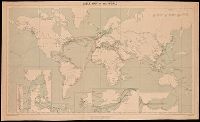
Description:
In lower right margin: Engd. by G. Aikman.
Publisher:
A. & C. Black,
Subject (Geographic):
World--maps
Subject (Topic):
Magnetic declination--Maps and World maps
Found in:
Beinecke Rare Book and Manuscript Library > A chart of magnetic curves of equal variation / by Peter Barlow.
Creator:
Published / Created:
1909
Call Number:
BrSides Double Folio 2018 95
Image Count:
1
Resource Type:
Maps, Atlases & Globes
Alternative Title:
G.S.G.S. ; No. 1849 and GSGS (Series) ; No. 1849
Description:
Backed with linen.
Publisher:
War Office,
Subject (Topic):
Cables, Submarine--Maps., Telegraph, Telegraph--Maps., and World maps
Found in:
Beinecke Rare Book and Manuscript Library > Cable map of the world [cartographic material].
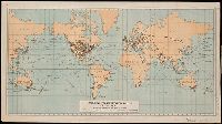
Creator:
Published / Created:
1896
Call Number:
BrSides Folio 2018 130
Image Count:
1
Resource Type:
Maps, Atlases & Globes
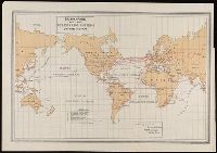
Description:
Imperfect: torn along bottom, with no loss of text.
Publisher:
[International Telecommunication Union],
Subject (Name):
Van Hoven, C.
Subject (Topic):
Telecommunication--Maps., Telegraph lines--Maps., and World maps
Found in:
Beinecke Rare Book and Manuscript Library > Carte générale des grandes communications télégraphiques du monde / dressée d'après des documents officiels par le Bureau International des Administrations Télégraphiques ; dessinée et gravée par C. v. Hoven.
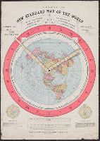
Published / Created:
1892.
Call Number:
11 1892
Image Count:
2
Resource Type:
cartographic image
Abstract:
Map of the globe stretched and flattened into a circular plane (azimuthal projection), with two movable arms to calculate time in places around the world
Alternative Title:
New standard map of the world
Description:
Map of the globe stretched and flattened into a circular plane.
Publisher:
Buffalo Electrotype and Engraving Co.
Subject (Topic):
Map projections and World maps
Found in:
Beinecke Rare Book and Manuscript Library > Gleason's new standard map of the world : on the projection of J.S. Christopher, Modern College, Blackheath, England ; scientifically and practically correct ; as "it is."
Creator:
Published / Created:
[1905?]
Call Number:
BrSides Double Folio 2018 91
Image Count:
1
Resource Type:
Maps, Atlases & Globes
Description:
Manuscript note in right margin: Transportation routes.
Publisher:
Department of Commerce and Labor, Bureau of Statistics,
Subject (Name):
Norris Peters Co
Subject (Topic):
Transportation--Maps and World maps
Found in:
Beinecke Rare Book and Manuscript Library > Principal transportation routes of the world.
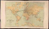
Creator:
Published / Created:
[1899]
Call Number:
BrSides Folio 2019 64
Image Count:
1
Resource Type:
Maps, Atlases & Globes
Description:
Includes explanation key.
Publisher:
Norris Peters Co.,
Subject (Name):
Norris Peters Co.
Subject (Topic):
Cables, Submarine--Maps. and World maps
Found in:
Beinecke Rare Book and Manuscript Library > Submarine and land telegraph systems of the world [cartographic material].
Creator:
Call Number:
11 1840C
Image Count:
1
Resource Type:
Maps, Atlases & Globes
Description:
Imperfect: chipped.
Subject (Name):
Copley, Charles, engraver, Karpinski, Louis Charles,--1878-1956--Ownership., Karpinski-von Wieser Map Collection., and Wieser, Franz,--Ritter von,--1848-1923--Ownership.
Subject (Topic):
World maps
Found in:
Beinecke Rare Book and Manuscript Library > The world on Mercator's projection : intermediate series / engraved by Charles Copley.
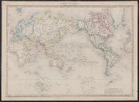
Creator:
Published / Created:
1852
Call Number:
11 1852A
Container / Volume:
BRBL_00009
Image Count:
1
Resource Type:
Maps, Atlases & Globes
Description:
Relief shown by hachures.
Subject (Geographic):
World--maps
Subject (Topic):
World maps
Found in:
Beinecke Rare Book and Manuscript Library > The world, on Mercator's projection.
Creator:
Published / Created:
[19--]
Call Number:
11 1538B
Image Count:
1
Resource Type:
Maps, Atlases & Globes
Description:
"Photolithographed copy of Gerard Mercator's Mapamundi of 1538 from an original engraving in the library of the American Geographical Society."
Publisher:
Julius Bien & Co., photo-lith,
Subject (Geographic):
World--Maps--Early works to 1800
Subject (Name):
American Geographical Society of New York and Julius Bien & Co
Subject (Topic):
Early maps, Early maps--Facsimiles, World maps, and World maps--Early works to 1800
Found in:
Beinecke Rare Book and Manuscript Library > [Mapamundi of 1538] [cartographic material].
Branch:v1.68.6 ,Deployed:2025-07-02T08:09:49-04:00