Skip to search
Skip to main content
Skip to first result
Search
You Searched For
Extent of Digitization
Completely digitized
Language
Dutch; Flemish
Search Results
Creator:
Published / Created:
ca. 1747?]
Call Number:
85 1702
Container / Volume:
BRBL_00692
Image Count:
1
Resource Type:
Maps, Atlases & Globes
Description:
Includes decorative cartouche showi
Publisher:
s.n.,
Subject (Geographic):
Caribbean Area--Maps--Early works to 1800, Mexico, Gulf of--Maps--Early works to 1800, and West Indies--Maps--Early works to 1800
Subject (Topic):
Coasts--North America--Maps--Early works to 1800 and Coasts--South America--Maps--Early works to 1800
Found in:
Beinecke Rare Book and Manuscript Library > Kaarte van de Golf van Mexico en het Zuyd America : waar in Porto-Bello en Panama aangewezen werden / B Ruyter Sc.
Published / Created:
1779
Call Number:
3331gmg H788 1749
Container / Volume:
BRBL_00701
Image Count:
1
Resource Type:
Maps, Atlases & Globes
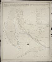
Description:
Manuscript map showing sandbanks of the southwest coast of the Island of Texel also waterdepths and their changes between the years 1749 and 1760.
Subject (Geographic):
North Holland (Netherlands)--Maps, Manuscript--Early works to 1800
Found in:
Beinecke Rare Book and Manuscript Library > Kaarte van de lengte en breete der Zand - Plaat genaamd De Horst ...
Published / Created:
1640?]
Call Number:
3333 1640
Container / Volume:
BRBL_00084
Image Count:
2
Resource Type:
Maps, Atlases & Globes
Description:
Preliminary record.
Subject (Geographic):
Zeeland (Netherlands : Province)--Maps--Early works to 1800
Found in:
Beinecke Rare Book and Manuscript Library > Kaerte van de vier Ambachten.
Creator:
Published / Created:
[1740?]
Call Number:
18 1740A
Container / Volume:
BRBL_00682
Image Count:
1
Resource Type:
Maps, Atlases & Globes
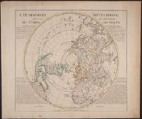
Description:
"Rectifier selon la carte de Monsieur Jean Kyrilow, premier secretaire de conseil de l'Empire de Russie publier en l'anne ́1734 ... "
Publisher:
Chez Jean Cóvens et Corneille Mortier,
Subject (Geographic):
Northern Hemisphere--Maps--Early works to 1800
Subject (Name):
Cóvens et Mortier
Found in:
Beinecke Rare Book and Manuscript Library > L'hemisphere septentrional pour voir plus distinctement les Terres Arctiques / par Guillaume de l'isle de l'Academie Rle. des Sciences.
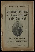
Creator:
Published / Created:
[1910?]
Call Number:
1982 142
Image Count:
24
Description:
Cover title.
Publisher:
[s.n.,] (Hodgson & Denne)
Subject (Topic):
Blacks--South Africa--Transvaal, Miners--South Africa--Transvaal, and Xhosa language--Texts
Found in:
Beinecke Rare Book and Manuscript Library > Life among the native and coloured miners in the Transvaal / by F.Z.S. Peregrino, in English, Dutch and Isi-Xosa.
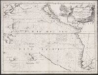
Creator:
Published / Created:
1691?]
Call Number:
23 1690
Container / Volume:
BRBL_00018
Image Count:
1
Resource Type:
Maps, Atlases & Globes
Alternative Title:
Mare del Sud, detto altrimenti Mare Pacifico
Description:
"Dedicato all' Illmo. et Eccmo. Signor. il Signor Cavalier Gvlio Givstinian Sauio Grande".
Subject (Geographic):
Pacific Ocean--Maps--Early works to 1800
Found in:
Beinecke Rare Book and Manuscript Library > Mare del Svd, detto altrimenti Mare Pacifico / Auttore Il P.M. Coronelli M.C. Cosmografo della serenissima Republica di Venetia.
Creator:
Published / Created:
1779
Call Number:
EKb 777H
Image Count:
28
Resource Type:
Books, Journals & Pamphlets
Publisher:
Nicolaas Byl,
Subject (Name):
Hopende Visser (Ship)
Subject (Topic):
Shipwrecks
Found in:
Beinecke Rare Book and Manuscript Library > Merkwaardig Verhaal van Reiner Hylkes, als Matroos, met het Schip de Hopende Visser Commandeur V. Jansz, ten Jare 1777. na Groenland uitgevaren op de Walvisvangst, en aldaar met 9 andere Schepen verongelukt ...
Published / Created:
1745
Call Number:
3331 H11 1745
Container / Volume:
BRBL_00082
Image Count:
1
Resource Type:
Maps, Atlases & Globes
Description:
Preliminary record.
Publisher:
Is. Tirion,
Subject (Geographic):
Haarlemmermeer (Netherlands)--Maps--Early works to 1800
Found in:
Beinecke Rare Book and Manuscript Library > Nauwkeurige Kaart Van de Haarlemmer of Leidsemeer ... door M. Bolstra Landmeeter van Rynland ...
Published / Created:
[1780?]
Call Number:
4078 1780
Container / Volume:
BRBL_00238
Image Count:
1
Resource Type:
Maps, Atlases & Globes
Subject (Geographic):
Calabria (Italy)--Maps--Early works to 1800
Found in:
Beinecke Rare Book and Manuscript Library > Neder-Calabrië naer deszelfs laatere Gesteltenis / J.S. de Roeder fec. et del. ; P. Mol sculp.
Creator:
Published / Created:
1962]
Call Number:
BrSides Box 2008 19
Image Count:
2
Alternative Title:
Danger! Do not lean out!, Det är livsfarligt att luta sig ut!, E pericoloso sporgesi!, Ne pas se pencher au dèhors [stet], Niet naar buiten hangen!, and Situationist times.
Description:
First line of text reads: Paris, a witches' cauldron of political instigations and demonstrations, armoured cars in the streets, the bloody shadow of the Algerian war, OAS, FLN, clearing murders and torture.
Publisher:
s.n.,
Subject (Name):
Gruppe SPUR and Internationale situationniste
Subject (Topic):
Situationism
Found in:
Beinecke Rare Book and Manuscript Library > Nicht Hinauslehnen! = Ne pas se pencher au dèhors [stet] = E pericoloso sporgesi! = Danger! Do not lean out! = Det är livsfarligt att luta sig ut! = Niet naar buiten hangen! / Jacqueline de Jong, Jörgen Nash, Ansgar Elde.
Branch:v1.70.9 ,Deployed:2025-11-11T09:47:22-05:00