"This map is copied from an original drawn by Monsr. D'Anv, Also appeared in Kitchin's General atlas describing the whole universe. London : Printed for Robert Sayer, [1780]., Prime meridians: Ferro and London., and Relief shown pictorially; depths by soundings.
Publisher:
Printed for Robert Sayer,
Subject (Geographic):
Africa, West--Maps--Early works to 1800
Subject (Name):
Abbot, Charles,--Baron Colchester,--1757-1829--Bookplate, Anville, Jean Baptiste Bourguignon d', 1697-1782, Kitchin, Thomas, d. 1784. General atlas describing the whole universe, and Robert Laurie and James Whittle
Imperfect: chipped., Insets: Canton River -- Van Diemen's Land -- Mouths of the River Hoogly -- Island and town of Singapore -- Colony of Good Hope., and Relief shown by hachures.
Subject (Name):
Copley, Charles, engraver, Karpinski, Louis Charles,--1878-1956--Ownership., Karpinski-von Wieser Map Collection., and Wieser, Franz,--Ritter von,--1848-1923--Ownership.
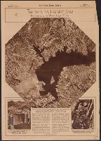
7 photos and text of international news on verso., Aerial photo from height of 20,000 ft. covering area of over 200 square miles., From The New York Times photogravure picture section, Sunday, September 1, 1935., and Includes text and photos of Hoover Dam and William Webber, cameraman.
Publisher:
New York Times,
Subject (Geographic):
Hoover Dam (Ariz. and Nev.)--Aerial views and Mead, Lake (Ariz. and Nev.)--Aerial views
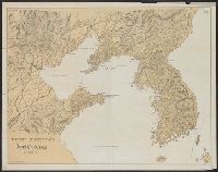
Covers northeastern portion of China; Gulf of Pechili-Liaodong Gulf area; and Korea north to the Russian border and south to the northern tip of Japan., Physical map not showing military operations., and Relief shown by hachures.
Index and guide., Inset: New York in 1729., and Valuable map of the city of New York. Plan of 1729, Plan of 1817. Formerly owned by Hon. J. Deming Perkins of Litchfield. Given to Mary Perkins Quincy (his niece) by Mrs. J. Deming Perkins. 1911.