Search
You Searched For
Search Results
- Published / Created:
- 1816
- Call Number:
- 851 1816
- Container / Volume:
- BRBL_00694
- Image Count:
- 1
- Resource Type:
- Maps, Atlases & Globes
- Alternative Title:
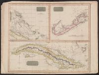
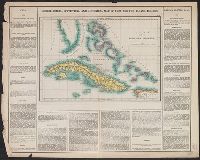
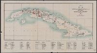
- Bermudas or Summer Islands. and Island of Cuba.
- Description:
- "Neele sculp. ... "
- Publisher:
- Drawn & engraved for Thomson's New General Atlas,
- Subject (Geographic):
- Bahamas--Maps, Bermuda Islands--Maps, Caribbean Area--Maps, and Cuba--Maps
- Subject (Name):
- John Thomson & Co. New general atlas and Neele, Samuel John, 1758-1824, engraver
- Found in:
- Beinecke Rare Book and Manuscript Library > Chart of the Bahama Islands [cartographic material] : The Bermudas or Summer Islands ; Island of Cuba.
- Published / Created:
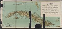
- [1897?]
- Call Number:
- 855cbf 1897A
- Container / Volume:
- BRBL_00642
- Image Count:
- 1
- Resource Type:
- Maps, Atlases & Globes
- Description:
- Imperfect. Mutilated. Map torn into 2 sheets, each encased in mylar.
- Publisher:
- James McConnell School Supply Co.,
- Subject (Geographic):
- Cuba--Maps
- Found in:
- Beinecke Rare Book and Manuscript Library > Cuba
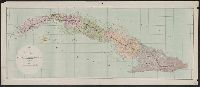
- Creator:
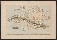
- Lucas, Fielding, Jr., 1781-1854
- Published / Created:
- [1823]
- Call Number:
- 855 1827B
- Container / Volume:
- BRBL_00641
- Image Count:
- 1
- Resource Type:
- Maps, Atlases & Globes
- Description:
- From Lucas's A general atlas containing distinct maps of all the known countries in the world, map # 81.
- Publisher:
- [F. Lucas, Jr.],
- Subject (Geographic):
- Cuba--Maps
- Subject (Name):
- B.T. Welch & Co and Lucas, Fielding, Jr., 1781-1854. A general atlas containing distinct maps of all the known countries in the world
- Found in:
- Beinecke Rare Book and Manuscript Library > Cuba / drawn and published by F. Lucas, Jr. ; B.T. Welch & Co., sc.
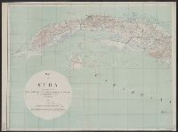
- Creator:
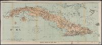
- U.S. Coast and Geodetic Survey
- Published / Created:
- 1898
- Call Number:
- 855hc 1898Q
- Container / Volume:
- BRBL_00765
- Image Count:
- 1
- Resource Type:
- Maps, Atlases & Globes
- Description:
- "482."
- Publisher:
- The Survey,
- Subject (Geographic):
- Cuba--Maps
- Subject (Topic):
- Nautical charts--Cuba
- Found in:
- Beinecke Rare Book and Manuscript Library > Cuba : part of chart "E" / Treasury Department, U.S. Coast and Geodetic Survey, Henry S. Pritchett, Superintendent.
- Creator:
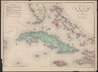
- Carey, Henry Charles, 1793-1879
- Published / Created:
- 1822]
- Call Number:
- 855 1827
- Container / Volume:
- BRBL_00695
- Image Count:
- 1
- Resource Type:
- Maps, Atlases & Globes
- Alternative Title:
- Geographical, statistical and historical map of Cuba and the Bahama Islands
- Description:
- From Carey's A complete historical, chronological, and geographical American atlas. Philadelphia, Pa. : H.C. Carey & I. Lea, 1822.
- Publisher:
- H.C. Carey & I. Lea,
- Subject (Geographic):
- Bahamas--Maps and Cuba--Maps
- Subject (Name):
- Carey & Lea, Carey, Henry Charles, 1793-1879. A complete historical, chronological, and geographical American atlas, and Tanner, Benjamin, 1775-1848
- Found in:
- Beinecke Rare Book and Manuscript Library > Cuba and the Bahama Islands / [cartographic material] / B. Tanner sc.
- Creator:
- Essex, Frank B
- Published / Created:
- 1911
- Call Number:
- 855 1911A
- Container / Volume:
- BRBL_00641
- Image Count:
- 1
- Resource Type:
- Maps, Atlases & Globes
- Description:
- Relief shown by form lines.
- Publisher:
- The Division,
- Subject (Geographic):
- Cuba--Maps
- Subject (Name):
- United States. War Dept. General Staff. War College Division and Williams, A. B
- Found in:
- Beinecke Rare Book and Manuscript Library > Map of Cuba / prepared in the War College Division, General Staff War Department ; drawn by Frank B. Essex & A.B. Williams.
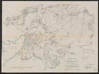
- Creator:
- Essex, Frank B
- Published / Created:
- 1911
- Call Number:
- 855 1911
- Container / Volume:
- BRBL_00641
- Image Count:
- 2
- Resource Type:
- Maps, Atlases & Globes
- Description:
- In legend: Based on military reconnaissances by the United States Army during the first and second occupation of Cuba, 1898-1902 and 1906-1909.
- Publisher:
- The Division,
- Subject (Geographic):
- Cuba--Maps
- Subject (Name):
- United States. War Dept. General Staff. War College Division and Williams, A. B
- Found in:
- Beinecke Rare Book and Manuscript Library > Map of Cuba / prepared in the War College Division, General Staff War Department ; drawn by Frank B. Essex & A.B. Williams.
- Published / Created:
- [1880?]
- Call Number:
- 855 1880
- Container / Volume:
- BRBL_00641
- Image Count:
- 1
- Resource Type:
- Maps, Atlases & Globes
- Description:
- Inset with historic, geographic, topographic, and demographic information.
- Publisher:
- H.H. Lloyd & Co.,
- Subject (Geographic):
- Cuba--Maps
- Found in:
- Beinecke Rare Book and Manuscript Library > Map of Cuba : "The Gem of the Antilles".
- Published / Created:
- 1916
- Call Number:
- 855gck 1916
- Container / Volume:
- BRBL_00642
- Image Count:
- 1
- Resource Type:
- Maps, Atlases & Globes
- Description:
- "April 1916".
- Publisher:
- E. Hence & Co., Inc.,
- Subject (Geographic):
- Cuba--Maps
- Found in:
- Beinecke Rare Book and Manuscript Library > Map of Cuba : showing all working sugar estates.
- Published / Created:
- [1898]
- Call Number:
- 855hc 1898O
- Container / Volume:
- BRBL_00765
- Image Count:
- 1
- Resource Type:
- Maps, Atlases & Globes
- Description:
- "Approx. difference in elevation between contour lines, 20 feet".
- Publisher:
- Norris Peters Co. Photo-litho,
- Subject (Geographic):
- Cuba--Maps
- Found in:
- Beinecke Rare Book and Manuscript Library > Map of Santiago de Cuba showing intrenchments and position of the 5th Corps. U.S. Army and those of the Spanish / compiled from partial transit surveys and foot reconnaisance notes and sketches by Lts. Guy, Smith, Cordray. of the Inf.; Lts. Batson and G.P