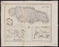
Draught of Port Royal or Kingston Harbour in Jamaica., Draught of the harbour of Port Antonio & St. Francis on the north east coast of Jamaica, and New and accurate map of the Island of Jamaica
Description:
From Bowen's Complete system of geography. London : Printed for William Innys, Richard Ware, Aaron Ward ..., 1747., London meridian., Scale given in English miles., Sheet measures 40.7 x 50.7 cm., and Shows boundaries, roads, forests, plantations and settlements.
Publisher:
s.n.,
Subject (Geographic):
Jamaica--Maps--Early works to 1800
Subject (Name):
Bowen, Emanuel, d. 1767. Complete system of geography
Subject (Topic):
Harbors--Jamaica--Kingston--Maps--Early works to 1800, Harbors--Jamaica--Port Antonio--Maps--Early works to 1800, and Harbors--Jamaica--Port Royal--Maps--Early works to 1800
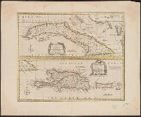
New & accurate map of the islands of Hispaniola or St. Domingo, and Porto Rico, New and accurate map of the island of Cuba, and New and accurate map of the islands of Hispaniola or St. Domingo, and Porto Rico
Description:
"No. 80.", Bar scale in English miles., Cross Collection no. 277., From Bowen's A complete system of geography ... London : Printed for W. Innys, R. Ware, Aaron Ward ..., 1747., Hand col., and Relief shown pictorially.
Publisher:
Printed for William Innys, Richard Ware, Aaron Ward ...,
Subject (Geographic):
Cuba--Maps--Early works to 1800, Hispaniola--Maps--Early works to 1800, and Puerto Rico--Maps--Early works to 1800
Subject (Name):
Bowen, Emanuel, d. 1767. Complete system of geography
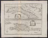
New & accurate map of the islands of Hispaniola or St. Domingo, and Porto Rico, New and accurate map of the island of Cuba, and New and accurate map of the islands of Hispaniola or St. Domingo, and Porto Rico
Description:
"No. 80.", Bar scale in English miles., From Bowen's A complete system of geography?, Relief shown pictorially., and Sheet measures 41.3 x 51.6 cm.
Publisher:
s.n.,
Subject (Geographic):
Cuba--Maps--Early works to 1800, Hispaniola--Maps--Early works to 1800, and Puerto Rico--Maps--Early works to 1800
Subject (Name):
Bowen, Emanuel, d. 1767. Complete system of geography
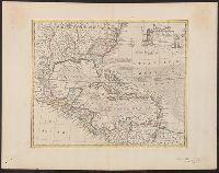
"No. 57.", From Bowen's A complete system of geography ... London : Printed for W. Innys, R. Ware, Aaron Ward ..., 1747., Includes bar scale in English miles., Relief shown pictorially., Sheet measures 44.9 x 58 cm. Cross Collection no. 243., and Shows sailing tracks, currents, shoals, etc.; includes historical notes and ornamental cartouche.
Publisher:
Printed for William Innys, Richard Ware, Aaron Ward ...,
Subject (Geographic):
Caribbean Area--Maps--Early works to 1800 and North America--Maps--Early works to 1800
Subject (Name):
Bowen, Emanuel, d. 1767. Complete system of geography