Search
You Searched For
Search Results
- Creator:
- Bright, R. G. T. (Richard George Tyndall)
- Published / Created:
- 1909
- Call Number:
- 632 1909
- Container / Volume:
- BRBL_00336
- Image Count:
- 1
- Resource Type:
- Maps, Atlases & Globes
- Found in:
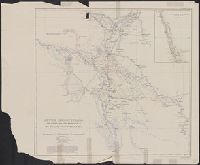
- Beinecke Rare Book and Manuscript Library > Central Equatorial Africa, survey of the Uganda-Congo boundary on the western frontier of the Uganda Protectorate / by the British Commission under the command of Lieut. Col. R.G.T. Bright, 1907-08.
- Published / Created:
- 1908
- Call Number:
- 652gme 1908
- Container / Volume:
- BRBL_00343
- Image Count:
- 1
- Resource Type:
- Maps, Atlases & Globes
- Found in:
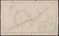
- Beinecke Rare Book and Manuscript Library > Congo State. Levels along lines of projected railways from the Upper Congo to Albert Nyanza and Tanganyika [cartographic material] / from Belgian official surveys.
- Creator:
- Evans, Arthur, Sir, 1851-1941
- Published / Created:
- 1916
- Call Number:
- 46f 1916
- Container / Volume:
- BRBL_00260
- Image Count:
- 1
- Resource Type:
- Maps, Atlases & Globes
- Found in:
- Beinecke Rare Book and Manuscript Library > Diagrammatic map of Slav territories east of the Adriatic [cartographic material] / by Sir Arthur Evans.
- Creator:
- Willcocks, William, Sir, 1852-1932
- Published / Created:
- [1912]
- Call Number:
- 533 1912A
- Container / Volume:
- BRBL_00287
- Image Count:
- 1
- Resource Type:
- Maps, Atlases & Globes
- Found in:
- Beinecke Rare Book and Manuscript Library > Lower Mesopotamia [cartographic material] / from surveys made under the direction of Sir William Willcocks, K.C.M.G., 1909-1911.
- Published / Created:
- 1908
- Call Number:
- 651 1908
- Container / Volume:
- BRBL_00342
- Image Count:
- 1
- Resource Type:
- Maps, Atlases & Globes
- Found in:
- Beinecke Rare Book and Manuscript Library > Part of north Angola : illustrating the journeys of Rev. Thomas Lewis, B.M.S., from 1899 to 1907.
- Creator:
- Turner, W. J. (William John)
- Published / Created:
- 1892
- Call Number:
- 534 1892
- Container / Volume:
- BRBL_00289
- Image Count:
- 1
- Resource Type:
- Maps, Atlases & Globes
- Found in:
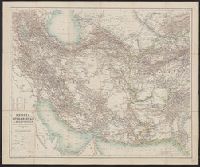
- Beinecke Rare Book and Manuscript Library > Persia, Afghanistan & Beluchistan [cartographic material] / compiled under the supervision of Hon. G. Curzon, M.P., by Wm. Jno. Turner, 1891.
- Creator:
- Steel, E. A., Lieut
- Published / Created:
- 1908
- Call Number:
- 6551 1908
- Container / Volume:
- BRBL_00346
- Image Count:
- 1
- Resource Type:
- Maps, Atlases & Globes
- Found in:
- Beinecke Rare Book and Manuscript Library > Recent explorations in southern Nigeria / by Lieut. E.A. Steel, 1904-7.
- Creator:
- Montandon, George, 1879-1944
- Published / Created:
- [1912]
- Call Number:
- 62 1912
- Container / Volume:
- BRBL_00333
- Image Count:
- 1
- Resource Type:
- Maps, Atlases & Globes
- Found in:
- Beinecke Rare Book and Manuscript Library > Routes in south western Abyssinia : from plane-table and prismatic compass traverses / by George Montandon, 1910-1911.
- Published / Created:
- 1909
- Call Number:
- 567 1909
- Container / Volume:
- BRBL_00300
- Image Count:
- 1
- Resource Type:
- Maps, Atlases & Globes
- Found in:
- Beinecke Rare Book and Manuscript Library > Sketch map of part of Tibet showing the explorations and journeys of Dr. Sven Hedin, 1906-1908. Published by the Royal Geographical Society.
- Creator:
- Hogarth, D. G. (David George), 1862-1927
- Published / Created:
- 1908
- Call Number:
- 53bh 1908
- Container / Volume:
- BRBL_00286
- Image Count:
- 1
- Resource Type:
- Maps, Atlases & Globes
- Found in:
- Beinecke Rare Book and Manuscript Library > Sketch map to illustrate a paper on unexplored western Asia [cartographic material] / by D.G. Hogarth.
- Published / Created:
- [1910]
- Call Number:
- 97 1910
- Container / Volume:
- BRBL_00678
- Image Count:
- 1
- Resource Type:
- Maps, Atlases & Globes
- Found in:
- Beinecke Rare Book and Manuscript Library > South Peru and north Bolivia [cartographic material] : including the rubber yielding montaña.
- Published / Created:
- [1910]
- Call Number:
- 97 1910A
- Container / Volume:
- BRBL_00678
- Image Count:
- 1
- Resource Type:
- Maps, Atlases & Globes
- Found in:
- Beinecke Rare Book and Manuscript Library > South Peru and north Bolivia [cartographic material] : including the rubber yielding montaña.
- Published / Created:
- [1910]
- Call Number:
- 97 1910
- Container / Volume:
- BRBL_00678
- Image Count:
- 1
- Resource Type:
- Maps, Atlases & Globes
- Found in:
- Beinecke Rare Book and Manuscript Library > South Peru and north Bolivia [cartographic material] : including the rubber yielding montaña.
- Published / Created:
- [1910]
- Call Number:
- 97 1910A
- Container / Volume:
- BRBL_00678
- Image Count:
- 1
- Resource Type:
- Maps, Atlases & Globes
- Found in:
- Beinecke Rare Book and Manuscript Library > South Peru and north Bolivia [cartographic material] : including the rubber yielding montaña.
- Published / Created:
- 1910
- Call Number:
- 649 1910
- Container / Volume:
- BRBL_00340
- Image Count:
- 1
- Resource Type:
- Maps, Atlases & Globes
- Found in:
- Beinecke Rare Book and Manuscript Library > South West Africa [cartographic material] : to illustrate a paper by Prof. H.H.W. Pearson.
- Published / Created:
- 1910
- Call Number:
- 533ex 1910
- Container / Volume:
- BRBL_00288
- Image Count:
- 1
- Resource Type:
- Maps, Atlases & Globes
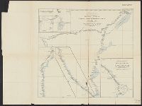
- Found in:
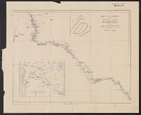
- Beinecke Rare Book and Manuscript Library > The Euphrates from Jerablus to Hit [cartographic material] : showing the route of Miss Gertrude Lowthian Bell along the eastern bank.
- Published / Created:
- 1904
- Call Number:
- 565 1904
- Container / Volume:
- BRBL_00299
- Image Count:
- 1
- Resource Type:
- Maps, Atlases & Globes
- Found in:
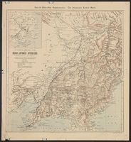
- Beinecke Rare Book and Manuscript Library > The Illustrated London news war-map of the Russo-Japanese operations in Manchuria and Korea / compiled from observations of R.T. Turley F.R.G.S, the latest Admiralty charts & Russian maps 1904.
- Creator:
- Canning, Alfred Wernam, 1860-1936
- Published / Created:
- 1911
- Call Number:
- 2651 W713 1911
- Container / Volume:
- BRBL_00023
- Image Count:
- 1
- Resource Type:
- Maps, Atlases & Globes
- Found in:
- Beinecke Rare Book and Manuscript Library > The Wiluna-Kimberley stock route [cartographic material] / by A.W. Canning.
- Creator:
- Garstin, William, Sir, 1849-1925
- Published / Created:
- 1909
- Call Number:
- 60bh 1909
- Container / Volume:
- BRBL_00329
- Image Count:
- 1
- Resource Type:
- Maps, Atlases & Globes
- Found in:
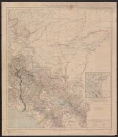
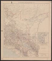
- Beinecke Rare Book and Manuscript Library > The jubilee of Speke's discovery of Victoria Nyanza : maps of Eastern Equatorial Africa showing the progress of exploration / to illustrate a paper by William E. Garstin.
- Creator:
- Garstin, William, Sir, 1849-1925
- Published / Created:
- 1909
- Call Number:
- 63bh 1909
- Container / Volume:
- BRBL_00335
- Image Count:
- 1
- Resource Type:
- Maps, Atlases & Globes
- Found in:
- Beinecke Rare Book and Manuscript Library > The jubilee of Speke's discovery of Victoria Nyanza : maps of Eastern Equatorial Africa showing the progress of exploration / to illustrate a paper by William E. Garstin.