Search
You Searched For
Search Results
- Creator:
- Homann Erben (Firm)
- Published / Created:
- 1737?]
- Call Number:
- 85 1759
- Container / Volume:
- BRBL_00693
- Image Count:
- 1
- Resource Type:
- Maps, Atlases & Globes
- Found in:
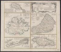
- Beinecke Rare Book and Manuscript Library > Dominia anglorum in praecipuis insulis Americae ut sunt insula : S. Christophori, Antegoa, Iamaica, Barbados, nec non insulae Bermudes vel Sommers dictae, singulari mappa omnia a exhibita et edita ab Homannianis Heredibus = Die englische Colonie-Laender a
- Creator:
- Lotter, Tobias Conrad, 1717-1777
Seutter, Matthaeus, 1678-1756
- Published / Created:
- 1758
- Call Number:
- 1973 Folio 30
- Collection Title:
- [Atlas factice of 32 maps and 1 distance table, produced by the Homann Erben firm]
- Image Count:
- 2
- Found in:
- Beinecke Rare Book and Manuscript Library > Ducatus Magdeburgensis et Halensis cum finitimis delineation geographica / [cartographic material] / curante Matthaeo Seuttero, Geographo. Caeser
- Creator:
- Lotter, Tobias Conrad, 1717-1777
Seutter, Matthaeus, 1678-1756
- Published / Created:
- ca. 1750
- Call Number:
- 1973 Folio 30
- Collection Title:
- [Atlas factice of 32 maps and 1 distance table, produced by the Homann Erben firm]
- Image Count:
- 2
- Found in:
- Beinecke Rare Book and Manuscript Library > Dynastiae comitat[us] Schoenbuirgici Penig, Remissa, Rochsburg, Wechselburg [cartographic material] : in clientela Elect. Saxon Glaucha, Hartenstein, Lichtenst. Stein, Waldenburg Praedia Benefic. S.R. Imp. ad circulum S.R.I. Saxoniae superiorem pertinente
- Creator:
- Lotter, Tobias Conrad, 1717-1777
Seutter, Matthaeus, 1678-1756
- Published / Created:
- ca. 1757
- Call Number:
- 1973 Folio 30
- Collection Title:
- [Atlas factice of 32 maps and 1 distance table, produced by the Homann Erben firm]
- Image Count:
- 2
- Found in:
- Beinecke Rare Book and Manuscript Library > Electoratus Saxonici Praefecturae Annaburgensis, Pretzschens[is] Torgaviensis, Schweinicensis, Muehlbergensis studio geographico / [cartographic material] / ita depictae, ut urbes, oppida, vici, pagi, aedes solitar cum vicinia accurate distingui possint a
- Creator:
- Lotter, Tobias Conrad, 1717-1777
Seutter, Matthaeus, 1678-1756
- Published / Created:
- [ca. 1758]
- Call Number:
- 1973 Folio 30
- Collection Title:
- [Atlas factice of 32 maps and 1 distance table, produced by the Homann Erben firm]
- Image Count:
- 2
- Found in:
- Beinecke Rare Book and Manuscript Library > Episcopatus Numburgensis et cizensis delineatio geographica adjectis praefecturis Portensi, Pegaviensi, Tautenburg et finitimis / [cartographic material] / cura Matth. Seutteri Geogr. Caes
- Creator:
- Münster, Sebastian, 1489-1552
- Published / Created:
- 1544]
- Call Number:
- 30 1544
- Container / Volume:
- BRBL_00732
- Image Count:
- 2
- Resource Type:
- Maps, Atlases & Globes
- Found in:
- Beinecke Rare Book and Manuscript Library > Europa, das ein Drittheil der Erden nach Gelegenheit unsern Zeiten.
- Creator:
- From the Collection: Hanbury-Williams, Charles, 1708-1759
- Published / Created:
- 1584 1717
- Call Number:
- LWL MSS 7
- Container / Volume:
- box 48, folder 11
- Image Count:
- 37
- Found in:
- Lewis Walpole Library > Charles Hanbury-Williams Papers (LWL MSS 7) > Series IV: Capell, Coningsby, and Hanbury Family Papers > Thomas Coningsby Papers > Collections > Five manuscript documents bound together
- Creator:
- Oterschaden, Johannes
- Published / Created:
- 1879
- Call Number:
- BrSides Folio 2019 81
- Image Count:
- 1
- Resource Type:
- Maps, Atlases & Globes
- Found in:
- Beinecke Rare Book and Manuscript Library > Globus aus der Mitte des XVI Jahrhunderts [terrestrial globe gores and rings].
- Creator:
- Oterschaden, Johannes, cartographer.
- Published / Created:
- 1879
- Call Number:
- 5 1550
- Container / Volume:
- BRBL_00271
- Image Count:
- 1
- Resource Type:
- Maps, Atlases & Globes
- Found in:
- Beinecke Rare Book and Manuscript Library > Globus aus der Mitte des XVI Jahrhunderts.
- Published / Created:
- 1737]
- Call Number:
- 8555 1737
- Container / Volume:
- BRBL_00695
- Image Count:
- 1
- Resource Type:
- Maps, Atlases & Globes
- Found in:
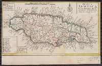
- Beinecke Rare Book and Manuscript Library > Insula Iamaica [cartographic material] : in suas parochias divisa et secundum exemplar primitivum Londinense excusa.