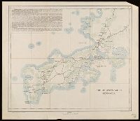
Littlehales, G. W. (George Washington), 1860-1943 Sigsbee, Charles D. (Charles Dwight), 1845-1923
Call Number:
18 1896
Container / Volume:
BRBL_00013
Image Count:
2
Resource Type:
Maps, Atlases & Globes
Description:
"Division of Chart Construction, G.W. Littlehales, Assistant in charge" and "Compiled by A.C. Roberts, Lithographed by Gr. Noetxel" printed inside circumference of map., "No.1531.", and Includes index detailing exploration of coasts and tracks of expeditions.
Noble jeu des armories de l'Europe enrichy de cartes geographiques and Noble play of ye heraldry & geography of Europe
Description:
"Most humbly dedicated to His most sacred Majesty George, King of Great Britain ... by ... I.I. Cheneviere.", "Rules of ye play.", English, French., and Geographical game to be played with dice.
2nd edition, 1st state, with entirely new plate from 1st edition that now shows all of Florida peninsula with title in cartouche., Below map is letterpress entitled: A compendious account of the British colonies in North America., Lower right corner of map includes Evan's polymetric table of America, with distances, and Thomas Templeman's survey of the size and area of the individual colonies., and Watermark.
Subject (Geographic):
North America--Maps--Early works to 1800 and United States--History--Revolution, 1775-1783--Maps
Subject (Name):
Jefferys, Thomas, -1771. and Robert Sayer and John Bennett (Firm)
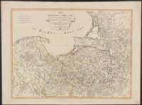
Vidal, A. T. E. (Alexander Thomas Emeric), 1792-1863, author
Call Number:
655 1827
Container / Volume:
BRBL_00345
Image Count:
1
Resource Type:
Maps, Atlases & Globes
Description:
Depths shown by isolines and soundings., Manuscript annotations on verso. Manuscript number in upper left corner: 666., Prime meridian: Greenwich., and Relief shown by hachures and spot heights.
Subject (Geographic):
Atlantic Coast (Africa)--Maps and South Atlantic Ocean--Navigation
Subject (Name):
Great Britain. Hydrographic Office, publisher, J. & C. Walker (Firm), engraver, Mudge, William, 1762-1820, and Owen, W. F. W., 1774-1857