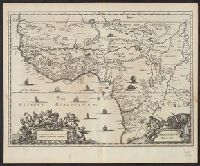
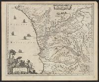
Covers coastal western and central Africa from Sierra Leone to Gabon., From Ogilby's Africa, being an accurate description of the regions, Includes ill. and decorative cartouche., Relief shown pictorially., and Verso: stamped "Map Collection Yale Univ. Library".
Publisher:
Printed by T. Johnson for the author,
Subject (Geographic):
Africa, Central--Maps--Early works to 1800 and Africa, West--Maps--Early works to 1800
Subject (Name):
Ogilby, John, 1600-1676. Africa, being an accurate description of the regions of Egypt, Barbary, Lybia and Billedulgerid
Subject (Topic):
Coasts--Africa, Central--Maps--Early works to 1800 and Coasts--Africa, West--Maps--Early works to 1800
Ogilby, John, 1600-1676 Ogilby, John, 1600-1676. Africa, being an accurate description of the regions of Egypt, Barbary
Published / Created:
1670]
Call Number:
299 1670
Container / Volume:
BRBL_00028
Image Count:
1
Resource Type:
Maps, Atlases & Globes
Description:
From Ogilby's Africa, being an accurate description of the regions of Egypt, Barbary, Lybia and Billedulgerid. 1670., Has watermarks., Includes ill. and decorative cartouche., and Relief shown pictorially.
Ogilby, John, 1600-1676 Ogilby, John, 1600-1676. Africa, being an accurate description of the regions of Egypt, Barbary
Published / Created:
1670]
Call Number:
214 1670
Image Count:
1
Resource Type:
Maps, Atlases & Globes
Description:
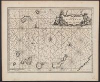
Covers the Canary Islands and Madeira Islands., From Ogilby's Africa, being an accurate description of the regions of Egypt, Barbary, Lybia and Billedulgerid. 1, Has watermarks., Includes ill., rhumb lines, and decorative cartouche., and Relief shown pictorially.
Publisher:
Printed by T. Johnson for the author,
Subject (Geographic):
Canary Islands--Maps--Early works to 1800 and Madeira Islands--Maps--Early works to 1800
Subject (Topic):
Nautical charts--Canary Islands--Early works to 1800 and Nautical charts--Madeira Islands--Early works to 1800
Ogilby, John, 1600-1676 Ogilby, John, 1600-1676. Africa, being an accurate description of the regions of Egypt, Barbary
Published / Created:
1670]
Call Number:
213 1670
Image Count:
1
Resource Type:
Maps, Atlases & Globes
Description:
From Ogilby's Africa, being an accurate description of the regions of Egypt, Barbary, Lybia and Billedulgerid. 1670., Has watermarks., Includes ill. and decorative cartouche., and Relief shown pictorially.
From Ogilby's Africa, being an accurate description of the regions of Egypt, Barbary, Lybia and Billedulgerid. 1670., Has watermarks., Includes ill. and decorative cartouche., and Relief shown pictorially.
Publisher:
Printed by T. Johnson for the author,
Subject (Geographic):
Africa, Central--Maps--Early works to 1800 and Africa, West--Maps--Early works to 1800
Subject (Name):
Ogilby, John, 1600-1676. Africa, being an accurate description of the regions of Egypt, Barbary, Lybia and Billedulgerid
From Ogilby's Africa, being an accurate description of the regions of Egypt, Barbary, Lybia and Billedulgerid. 1670., Has watermarks., Includes ill. and decorative cartouche., Oriented with north to the left., and Relief shown pictorially.
Publisher:
Printed by T. Johnson for the author,
Subject (Geographic):
Egypt--Maps--Early works to 1800
Subject (Name):
Ogilby, John, 1600-1676. Africa, being an accurate description of the regions of Egypt, Barbary, Lybia and Billedulgerid
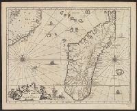
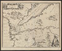
Covers coastal and interior central Africa from Port-Gen, From Ogilby's Africa, being an accurate description of the regions of Egypt, Barbary, Lybia and Billedulgerid. 1670., Has watermarks., Includes ill. and decorative cartouche., and Relief shown pictorially.
Publisher:
Printed by T. Johnson for the author,
Subject (Geographic):
Africa, Central--Maps--Early works to 1800
Subject (Name):
Ogilby, John, 1600-1676. Africa, being an accurate description of the regions of Egypt, Barbary, Lybia and Billedulgerid
Nieuhof, Johannes, 1618-1672 Ogilby, John, 1600-1676 Ogilby, John, 1600-1676. Africa, being an accurate description of the regions of Egypt, Barbary
Published / Created:
1670]
Call Number:
215 1670
Container / Volume:
BRBL_00015
Image Count:
1
Resource Type:
Maps, Atlases & Globes
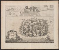
Alternative Title:
Saint Helena
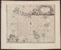
Description:
Dutch and English., From Ogilby's Africa, being an accurate description of the regions of Egypt, Barbary, Lybia and Billedulgerid. 1670., Has watermarks., Includes ill. and indexes., Oriented with north toward the lower left., and Relief shown pictorially.
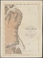
Des Barres, Joseph F. W. (Joseph Frederick Wallet), 1722-1824
Published / Created:
Sept. 1 1781.
Call Number:
733cea R49 1781
Container / Volume:
BRBL_00379
Image Count:
1
Resource Type:
Maps, Atlases & Globes
Description:
From the author's Atlantic Neptune.
Publisher:
J.F.W. Des Barres,
Subject (Name):
Des Barres, Joseph F. W. (Joseph Frederick Wallet), 1722-1824. Atlantic neptune
Subject (Topic):
Coasts--New Brunswick--Maps--Early works to 1800, Harbors--New Brunswick--Maps--Early works to 1800, and Nautical charts--New Brunswick--Early works to 1800
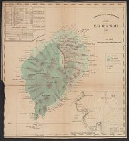
Portugal. Comissão de Cartografia das Colónias, author
Call Number:
6514 1885
Container / Volume:
BRBL_00342
Image Count:
1
Resource Type:
Maps, Atlases & Globes
Description:
Imperfect: trimmed in lower left corner, with some loss of graticule., Inset: Planta da Bahia de Anna de Chaves., and Relief shown by hachures and spot heights.
Subject (Geographic):
São Tomé Island (Sao Tome and Principe)--Maps
Subject (Name):
Oliveira, A. A. de and Vasconcellos, Ernesto J. de C. e (Ernesto Julio de Carvalho), 1852-1930