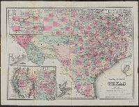
"Entered according to act of Congress in the year 1875 by G.W. & C.B. Colton & Co. in the office of the Librarian of Congress, at Washington.", Includes advertisements on verso., Includes maps of "Northern part or panhandle of Texas," "Plan of Matagorda Bay," "Western portion of the United States," "Plan of Galveston Bay," and "Plan of Sabine Lake.", Prime meridians: Greenwich and Washington., Relief shown by hachures., and Shows counties.
Publisher:
Albert Hanford,
Subject (Geographic):
Texas Panhandle (Tex.)--Maps, Texas--Administrative and political divisions--Maps, and Texas--Maps