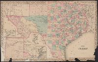
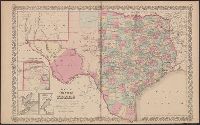
"Entered according to act of Congress in the year 1873 by G.W. & C.B. Colton & Co. in the office of the Librarian of Congress at Washington.", Insets: Plan of Matagorda Bay. Scale [ca. 1:1,060,000] -- Plan of the, and Prime meridians: Greenwich and Washington.
Publisher:
G.W. & C.B. Colton & Co.,
Subject (Geographic):
Texas Panhandle (Tex.)--Maps, Texas--Administrative and political divisions--Maps, and Texas--Maps
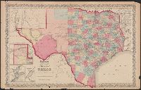
"No.35" and "No.36.", Includes Frio and Zavala counties which were formed in 1858 and which do not appear on Colton map dated 1857., Insets: Plan of the northern part of Te, and Library's copy annotated in pencil "This is in the same state as in the 1859 atlas."
Publisher:
Johnson & Browning,
Subject (Geographic):
Texas Panhandle (Tex.)--Maps, Texas--Administrative and political divisions--Maps, and Texas--Maps
Subject (Name):
De Cordova, Jacob, 1808-1868, J.H. Colton & Co, Johnson & Browning, and Streeter, Thomas W.--(Thomas Winthrop),--1883-1965--Ownership
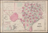
"46" and "47.", Insets: Plan of Sabine Lake. Scale [ca. 1:500,000] -- Plan of the northern part of Texas. Scale [ca. 1:3,700,000] -- Plan of Galveston Bay. Scale [ca.1:777,741]., Prime meridians: Greenwich and Washington., Relief shown by hac, and Shows counties.
Publisher:
s.n.,
Subject (Geographic):
Texas Panhandle (Tex.)--Maps, Texas--Administrative and political divisions--Maps, and Texas--Maps
"Entered according to act of Congress in the year 1875 by G.W. & C.B. Colton & Co. in the office of the Librarian of Congress, at Washington.", Includes advertisements on verso., Includes maps of "Northern part or panhandle of Texas," "Plan of Matagorda Bay," "Western portion of the United States," "Plan of Galveston Bay," and "Plan of Sabine Lake.", Prime meridians: Greenwich and Washington., Relief shown by hachures., and Shows counties.
Publisher:
Albert Hanford,
Subject (Geographic):
Texas Panhandle (Tex.)--Maps, Texas--Administrative and political divisions--Maps, and Texas--Maps
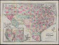
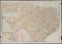
"Compiled from J. De Cordova's large map.", "Entered according to act of Congress in the year 18[55?] by J.H. Colton & Co. in the clerks office of the district court of the United States for the southern district of New York.", "No.35" and "No. 36.", Includes Frio and Zavala counties which were formed in 1858., Insets: Plan of the northern part of Texas. Scale [ca. 1:3,800,000] -- Plan of Galveston Bay. Scale [ca. 1:1,036,987] -- Plan of Sabine Lake. Scale [ca. 1:500,000]., Prime meridians: Greenwich and Washington., Relief shown by hachures., Shows counties., and Text of "The state of Arkansas and the Indian Territory" on verso.
Publisher:
J.H. Colton & Co.,
Subject (Geographic):
Texas Panhandle (Tex.)--Maps, Texas--Administrative and political divisions--Maps, and Texas--Maps
New map of the state of Texas, Texas, and Texas almanac for ...
Description:
"Entered according to act of Congress in the year 1866 by G.W. & C.B Colton & Co. in clerks office of the district court of the United States for the southern district of New York.", Prime meridians: Greenwich and Washington., Relief shown by hachures., and Shows counties and railroads.
Publisher:
G.W. & C.B. Colton & Co's Map Establishment,
Subject (Geographic):
Texas Panhandle (Tex.)--Maps, Texas--Administrative and political divisions--Maps, and Texas--Maps
Subject (Name):
G.W. & C.B. Colton & Co and Richardson, Willard, 1802-1875
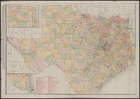
New business atlas map of Texas, New commercial atlas map of Texas, Rand McNally & Co.'s new business atlas map of Texas, and Texas
Description:
Includes insets of the panhandle and southern Texas and indexes., Library's copy annotated in blue pencil and black ink., Relief shown by hachures and spot heights., and Shows counties and railroads.
Publisher:
Rand McNally,
Subject (Geographic):
Texas Panhandle (Tex.)--Maps, Texas--Administrative and political divisions--Maps, and Texas--Maps