Skip to search
Skip to main content
Skip to first result
Search
You Searched For
"Missouri"
Extent of Digitization
Completely digitized
Resource Type
Maps, Atlases & Globes
New Search
Search Results
Creator:
Published / Created:
1857
Call Number:
824 1857D
Container / Volume:
BRBL_00570
Image Count:
1
Resource Type:
Maps, Atlases & Globes
Alternative Title:
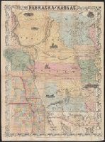
Territory acquired from Mexico by the Gadsden Treaty.
Description:
, Iowa, and Missouri , and map of "Territory
Publisher:
J.H. Colton & Co.,
Subject (Geographic):
Kansas--Maps, Nebraska--Maps, and West (U.S.)--Maps
Subject (Name):
Mexico.--Treaties, etc.--United States,--1853 Dec. 30--Maps
Found in:
Beinecke Rare Book and Manuscript Library > Nebraska and Kansas.
Creator:
Published / Created:
1857
Call Number:
824 1857D
Container / Volume:
BRBL_00570
Image Count:
1
Resource Type:
Maps, Atlases & Globes
Alternative Title:
Territory acquired from Mexico by the Gadsden Treaty.
Description:
, Iowa, and Missouri , and map of "Territory
Publisher:
J.H. Colton & Co.,
Subject (Geographic):
Kansas--Maps, Nebraska--Maps, and West (U.S.)--Maps
Subject (Name):
Mexico.--Treaties, etc.--United States,--1853 Dec. 30--Maps
Found in:
Beinecke Rare Book and Manuscript Library > Nebraska and Kansas.
Creator:
Published / Created:
[1855 or 1856?]
Call Number:
814 1855G
Container / Volume:
BRBL_00557
Image Count:
1
Resource Type:
Maps, Atlases & Globes
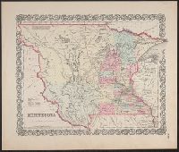
Description:
Chippewa areas, with Missouri River and White
Publisher:
J.H. Colton & Co.,
Subject (Geographic):
Minnesota--Maps, North Dakota--Maps, and South Dakota--Maps
Subject (Name):
Colton, G. Woolworth (George Woolworth), 1827-1901. Colton's atlas of the world
Found in:
Beinecke Rare Book and Manuscript Library > Minnesota.
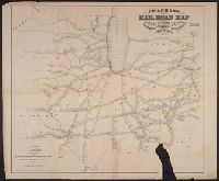
Creator:
Published / Created:
1850, c1849.
Call Number:
754 1850
Container / Volume:
BRBL_00416
Image Count:
1
Resource Type:
Maps, Atlases & Globes
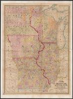
Alternative Title:
Map of the states of Missouri , Illinois
Description:
Prime meridians: Greenwich and Washington. and Shows drainage, counties, townships, settlements, roads, railroads and canals.
Publisher:
Thomas, Cowperthwait & Co.,
Subject (Geographic):
Middle West--Maps
Subject (Name):
Hazzard, J. L and Thomas, Cowperthwait & Co
Found in:
Beinecke Rare Book and Manuscript Library > Map of the states of Missouri, Illinois, Iowa and Wisconsin : the territory of Minnesota, and the mineral lands of Lake Superior / compiled by I.S. Drake ; engraved by Ira S. Drake and J.L. Hazzard.
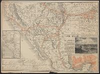
Creator:
Published / Created:
[1886?]
Call Number:
80gme 1885A
Container / Volume:
BRBL_00539
Image Count:
2
Resource Type:
Maps, Atlases & Globes
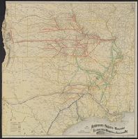
Alternative Title:
Santa Fé route : and Santa Fé route to the city of Mexico by the Atchison, Topeka and Santa Fé R.R. and Mexican Central R.R.
Description:
"February" on panel and "November 29, 1885" on timetable., Covers southweste, Relief shown by hachures., Shows cities and towns, stations, Indian reservations, state boundaries, and the railroad network emphasizing the main line., and Text and timetable on verso.
Publisher:
Rand, McNally,
Subject (Name):
Atchison, Topeka, and Santa Fe Railroad Company, Atchison, Topeka, and Santa Fe Railroad Company--Maps, Mexican Central Railway Co, and Mexican Central Railway Co.--Maps
Subject (Topic):
Railroads--Mexico--Maps, Railroads--Mexico--Timetables, Railroads--Southwestern States--Maps, and Railroads--Southwestern States--Timetables
Found in:
Beinecke Rare Book and Manuscript Library > The Santa Fé route and connections : Missouri River to Pacific Coast & Mexico.
Branch:v1.61.6 ,Deployed:2024-06-12T09:55:36-04:00