Skip to search
Skip to main content
Skip to first result
Search
You Searched For
"Missouri"
Extent of Digitization
Completely digitized
Resource Type
Maps, Atlases & Globes
New Search
Search Results
Creator:
Published / Created:
[between 1900 and 1910]
Call Number:
Zc41 900se
Image Count:
2
Resource Type:
Maps, Atlases & Globes
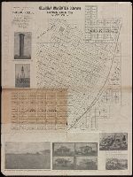
Alternative Title:
the Missouri , Kansas & Texas lines
Description:
Coordinates not present on map and are approximated. and With inset map of "Katy Heights."
Publisher:
[Oklahoma Immigration Company?],
Subject (Geographic):
Caddo (Okla.)--Maps.
Subject (Name):
Oklahoma Immigration Company.
Subject (Topic):
Real property--Oklahoma--Caddo--Maps.
Found in:
Beinecke Rare Book and Manuscript Library > Original townsite of Caddo, Okla. and additions / Chas. C. Semple, surveyor.
Creator:
Published / Created:
1918
Call Number:
80gme 1918
Container / Volume:
BRBL_00540
Image Count:
1
Resource Type:
Maps, Atlases & Globes
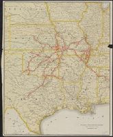
Description:
"No. 2 2-18."
Publisher:
Parker Engraving Company,
Subject (Name):
St. Louis-San Francisco Railway Company--Maps
Subject (Topic):
Railroads--Missouri --Maps
Found in:
Beinecke Rare Book and Manuscript Library > St. Louis-San Francisco Railway and auxiliary lines : December 31, 1918 / Parker Engraving Company.
Creator:
Published / Created:
[1887?]
Call Number:
816 K134 1887A
Container / Volume:
BRBL_00562
Image Count:
1
Resource Type:
Maps, Atlases & Globes
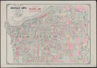
Description:
"Entered according to act of Congress in the year 1887 by G.M. Hopkins in the office of the Librarian of Congress at Washington, D.C.", Includes advertisement for S.F. Scott & Co. real estate., and Shows numbered lots, landowners, and railroads.
Publisher:
G.M. Hopkins,
Subject (Geographic):
Kansas City (Mo.)--Maps and Kansas City Metropolitan Area (Mo.)--Maps
Found in:
Beinecke Rare Book and Manuscript Library > Map of Kansas City, Missouri and vicinity : compiled from official records and actual surveys.
Creator:
Published / Created:
1848
Call Number:
80 1848C
Container / Volume:
BRBL_00533
Image Count:
1
Resource Type:
Maps, Atlases & Globes
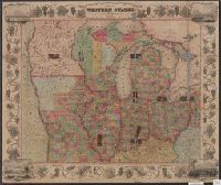
Alternative Title:
, Illinois, Missouri , Iowa, and Wisconsin.
Description:
, Michigan, Indiana, Illinois, Missouri , Iowa
Publisher:
Ensigns & Thayer,
Subject (Geographic):
Middle West--Maps
Found in:
Beinecke Rare Book and Manuscript Library > Map of the western states / drawn & engraved by J.M. Atwood.
Creator:
Published / Created:
1876
Call Number:
80 1876A
Container / Volume:
BRBL_00535
Image Count:
1
Resource Type:
Maps, Atlases & Globes
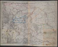
Description:
At head of title: War Department., Includes list of authorities., Library's copy annotated in color ink to highlight forts and show Indian lands., Relief shown by hachures., and Shows railroads, trails, and routes.
Publisher:
Office of the Chief of Engineers, U.S. Army,
Subject (Geographic):
Missouri River Watershed--Maps
Subject (Name):
Maynadier, Henry Eveleth, d. 1868, Raynolds, W. F. (William Franklin), 1820-1894, and United States. Army. Office of the Chief of Engineers
Found in:
Beinecke Rare Book and Manuscript Library > Map of the Yellowstone and Missouri Rivers and their tributaries / explored by W.F. Raynolds and H.E. Maynadier, 1859-60 ; revised and enlarged by G.L. Gillespie ; engraved in the Office of the Chief of Engineers.
Published / Created:
[1890?]
Call Number:
796gme 1890
Container / Volume:
BRBL_00531
Image Count:
1
Resource Type:
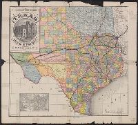
Maps, Atlases & Globes
Description:
., Missouri Pacific Railway Co., Houston & Texas
Publisher:
Land Dept. of the Texas & Pacific Railway Co.,
Subject (Geographic):
Texas--Administrative and political divisions--Maps and Texas--Maps
Subject (Name):
Texas & Pacific Railway. Land Dept and Texas & Pacific Railway--Maps
Subject (Topic):
Railroad land grants--Texas--Maps and Railroads--Texas--Maps
Found in:
Beinecke Rare Book and Manuscript Library > A geographically correct map of the state of Texas.
Published / Created:
1879?]
Call Number:
825 K134 1879
Container / Volume:
BRBL_00574
Image Count:
1
Resource Type:
Maps, Atlases & Globes
Alternative Title:
Kansas City and surroundings.
Description:
"S.N. Simpson, real estate dealer, office 505 Delaware St., Kansas City and at Riverview.", Riverview map includes text., and Shows numbered lots and property owners.
Publisher:
s.n.,
Subject (Geographic):
Kansas City Metropolitan Area (Kan.)--Maps, Kansas City Metropolitan Area (Mo.)--Maps, and Riverview (Kan.)--Maps
Subject (Name):
O'Flaherty, Daniel, civil eng'r, Ramsey, Millett & Hudson, Simpson, S. N, and Smith, D. M
Subject (Topic):
Real property--Missouri --Kansas City
Found in:
Beinecke Rare Book and Manuscript Library > Riverview, Wyandott County, Kansas / surveyed April 2nd 1879 by Dan'l OFlaherty, civil eng'r. Kansas City and surroundings / compiled and drawn by D.M. Smith, Wyandott, Kansas ; Ramsey, Millett & Hudson, map engravers, Kns. City Mo.
Published / Created:
1887]
Call Number:
825 K134 1887
Container / Volume:
BRBL_00574
Image Count:
1
Resource Type:
Maps, Atlases & Globes
Alternative Title:
Kansas City times (Kansas City, Mo. : 1884)
Description:
"The 'mile lines' radiate from Ninth and Main Streets, MacCormac Eng. Phila."
Publisher:
Kansas City Times Co.?,
Subject (Geographic):
Kansas City Metropolitan Area (Kan.)--Maps and Kansas City Metropolitan Area (Mo.)--Maps
Found in:
Beinecke Rare Book and Manuscript Library > Map of the vicinity of Kansas City in Kansas and Missouri / presented by the "Kansas City Times," January 1st, 1887.
Published / Created:
1888]
Call Number:
825 K134 1888
Container / Volume:
BRBL_00574
Image Count:
1
Resource Type:
Maps, Atlases & Globes
Alternative Title:
Kansas City times (Kansas City, Mo. : 1884)
Description:
"The 'mile lines' radiate from The Times Building, Ninth and Main Streets, MacCormac Eng. Phila."
Publisher:
Kansas City Times Co.?,
Subject (Geographic):
Kansas City Metropolitan Area (Kan.)--Maps and Kansas City Metropolitan Area (Mo.)--Maps
Found in:
Beinecke Rare Book and Manuscript Library > Map of the vicinity of Kansas City in Kansas and Missouri / presented by the "Kansas City Times," January 1st, 1888.
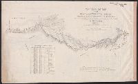
Creator:
Published / Created:
1846]
Call Number:
80 1846A
Container / Volume:
BRBL_00533
Image Count:
7
Resource Type:
Maps, Atlases & Globes
Publisher:
s.n.,
Subject (Geographic):
Oregon National Historic Trail--Maps and West (U.S.)--Maps
Subject (Name):
Edward Weber & Co, Frémont, John Charles, 1813-1890, and United States. Congress. Senate
Found in:
Beinecke Rare Book and Manuscript Library > Topographical map of the road from Missouri to Oregon : commencing at the mouth of the Kansas in the Missouri River and ending at the mouth of the Wallah Wallah in the Columbia / from the field notes and journal of Capt. J.C. Frémont, and from sketches a
Branch:v1.61.6 ,Deployed:2024-06-12T09:55:36-04:00