Search
You Searched For
Search Results
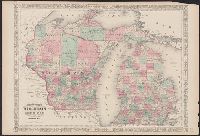
- Creator:
- Johnson, A. J. (Alvin Jewett), 1827-1884
- Published / Created:
- [1866]
- Call Number:
- 812 1866
- Container / Volume:
- BRBL_00555
- Image Count:
- 2
- Resource Type:
- Maps, Atlases & Globes
- Alternative Title:
- Wisconsin and Michigan
- Subject (Geographic):
- Michigan--Maps
- Subject (Topic):
- Counties--Michigan--Maps
- Found in:
- Beinecke Rare Book and Manuscript Library > Johnson's Wisconsin and Michigan.
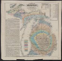
- Creator:
- Winchell, Alexander, 1824-1891
- Published / Created:
- 1866
- Call Number:
- 811ca 1866
- Container / Volume:
- BRBL_00554
- Image Count:
- 1
- Resource Type:
- Maps, Atlases & Globes
- Description:
- Michigan," population table, and inset of Isle
- Subject (Geographic):
- Michigan--Maps
- Subject (Topic):
- Geology--Michigan--Maps
- Found in:
- Beinecke Rare Book and Manuscript Library > Geological map of Michigan / by Alexander Winchell.
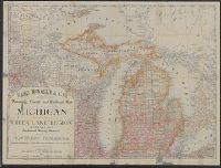
- Creator:
- Rand McNally and Company
- Published / Created:
- 1879
- Call Number:
- 811 1879
- Container / Volume:
- BRBL_00552
- Image Count:
- 1
- Resource Type:
- Maps, Atlases & Globes
- Alternative Title:
- Michigan with a new and original index.
- Subject (Geographic):
- Michigan--Administrative and political
- Subject (Topic):
- Railroads--Michigan--Maps
- Found in:
- Beinecke Rare Book and Manuscript Library > Rand, McNally & Co.'s township, county and railroad map of Michigan and the entire Upper Lake Region : showing the celebrated mining districts of the Upper Peninsula / compiled from the U.S. Land Office and Lake Surveys, County Surveys, etc.
- Published / Created:
- 1919
- Call Number:
- 811gmb 1919A
- Container / Volume:
- BRBL_00554
- Image Count:
- 1
- Resource Type:
- Maps, Atlases & Globes
- Subject (Geographic):
- Michigan--Lower Peninsula--Maps
- Subject (Topic):
- Roads--Michigan--Maps
- Found in:
- Beinecke Rare Book and Manuscript Library > State of Michigan, Lower Peninsula as the trunk line system looked July 1, 1919 / prepared by State Highway Dept.
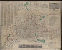
- Creator:
- Detroit United Railway
- Published / Created:
- [1900?]
- Call Number:
- 811am D48 1900
- Container / Volume:
- BRBL_00554
- Image Count:
- 2
- Resource Type:
- Maps, Atlases & Globes
- Description:
- interest in southeast Michigan ; chart for
- Subject (Topic):
- Street-railroads--Michigan--Detroit
- Found in:
- Beinecke Rare Book and Manuscript Library > Trolley rides in city and country [cartographic material] : to charming rural scenery, beautiful lakes and majestic rivers via Detroit United Railway.
- Creator:
- Middleton, Strobridge & Co
- Published / Created:
- [1857].
- Call Number:
- 753gme 1858
- Container / Volume:
- BRBL_00415
- Image Count:
- 1
- Resource Type:
- Maps, Atlases & Globes
- Description:
- Mackinaw connecting Lake Michigan and Lake
- Subject (Topic):
- Counties--Michigan--Maps
- Found in:
- Beinecke Rare Book and Manuscript Library > Map illustrating the Canada Pacific and Northern Pacific and other proposed Railroads, connecting at Straits of Mackinaw : Also showing the position of Mackinaw City.
- Creator:
- Silas Farmer & Co.
- Published / Created:
- 1911-12 [i.e. 1911?], and c1911.
- Call Number:
- 811 D48 1911
- Container / Volume:
- BRBL_00553
- Image Count:
- 1
- Resource Type:
- Maps, Atlases & Globes
- Subject (Topic):
- Streets--Michigan--Detroit Metropolitan
- Found in:
- Beinecke Rare Book and Manuscript Library > A new map of Detroit and suburbs : includes River Rouge, Oakwood, Highland Park, Hamtramck, St. Clair Heights, and Grosse Pointe.
- Published / Created:
- 1844
- Call Number:
- 755 1844
- Container / Volume:
- BRBL_00441
- Image Count:
- 1
- Resource Type:
- Maps, Atlases & Globes
- Description:
- the printed maps of Michigan, 1804-1880
- Found in:
- Beinecke Rare Book and Manuscript Library > Guide through Ohio, Michigan, Indiana, Illinois, Missouri, Wisconsin & Iowa by J. Calvin Smith ...
- Creator:
- Haas, P
- Published / Created:
- 1841]
- Call Number:
- 811fcm 1840
- Container / Volume:
- BRBL_00554
- Image Count:
- 1
- Resource Type:
- Maps, Atlases & Globes
- Description:
- Shows all of Michigan north of Grand
- Subject (Geographic):
- Michigan--Maps
- Found in:
- Beinecke Rare Book and Manuscript Library > Sketch of the public surveys in the north part of Michigan / lith. of P. Haas.
- Creator:
- Noble, Charles
- Published / Created:
- 1850
- Call Number:
- 811fcm 1850
- Container / Volume:
- BRBL_00554
- Image Count:
- 1
- Resource Type:
- Maps, Atlases & Globes
- Subject (Geographic):
- Michigan--Maps
- Found in:
- Beinecke Rare Book and Manuscript Library > Sketch of the public surveys in Michigan / Surveyor General's Office, Detroit, November 12th, 1850, Charles Noble, Surveyor General.