Skip to search
Skip to main content
Skip to first result
Search
You Searched For
Date
1900 - 1949
"Massachusetts"
Extent of Digitization
Completely digitized
Resource Type
Maps, Atlases & Globes
Date Created
1900 to 1949
New Search
Search Results
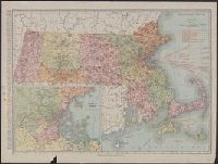
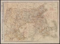
Creator:
Published / Created:
[1911]
Call Number:
764 1911
Container / Volume:
BRBL_00453
Image Count:
1
Resource Type:
Maps, Atlases & Globes
Description:
principal cities, list of Massachusetts
Publisher:
Rand McNally & Co.,
Subject (Geographic):
Massachusetts --Maps
Subject (Topic):
Railroads--Massachusetts --Maps
Found in:
Beinecke Rare Book and Manuscript Library > Massachusetts.
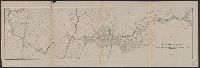
Creator:
Massachusetts . Metropolitan Park Commission
Published / Created:
1908
Call Number:
764 B65 1908
Container / Volume:
BRBL_00456
Image Count:
1
Resource Type:
Maps, Atlases & Globes
Description:
"Herbert J. Kellaway, Landscape Architect, Boston, Mass., March 1908.", "William G. Smith, Del.", and From: Report of the Board of Metropolitan Park Commissioners, Dec. 1910.
Publisher:
The Commission],
Subject (Geographic):
Massachusetts --Maps
Subject (Name):
Kellaway, Herbert J
Subject (Topic):
Recreation areas--Massachusetts
Found in:
Beinecke Rare Book and Manuscript Library > Plan for proposed park and parkways : from Charles River Reservation to West Roxbury Parkway connecting the northern and southern group of metropolitan parks.
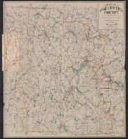
Creator:
Published / Created:
c1904.
Call Number:
764 W89 1904
Container / Volume:
BRBL_00460
Image Count:
1
Resource Type:
Maps, Atlases & Globes
Alternative Title:
Worcester County, Massachusetts
Description:
, Massachusetts .
Publisher:
Geo. H. Walker & Co.,
Subject (Geographic):
Worcester County (Mass.)--Maps
Subject (Topic):
Cycling--Massachusetts --Worcester
Found in:
Beinecke Rare Book and Manuscript Library > Map of Worcester County, Mass. / published by Geo. H. Walker & Co.
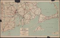
Creator:
Published / Created:
[1917].
Call Number:
76gmb 1917
Container / Volume:
BRBL_00446
Image Count:
1
Resource Type:
Maps, Atlases & Globes
Description:
, Massachusetts Highway Commission, Massachusetts
Publisher:
C.S. Hammond & Co.,
Subject (Geographic):
Massachusetts --Maps
Found in:
Beinecke Rare Book and Manuscript Library > Hammond's new road map of Rhode Island and southeastern Massachusetts.
Creator:
Published / Created:
[1909]
Call Number:
764 B65 1909E
Container / Volume:
BRBL_00456A
Image Count:
1
Resource Type:
Maps, Atlases & Globes
Alternative Title:
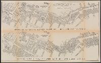
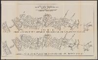
Existing streets between Cambridge Bridge and North Station. and Proposed connection between Cambridge Bridge and North Station.
Description:
"Jan. 1909.", Proposed connection between Cambridge Bridge and North Station -- Existing streets between Cambridge Bridge and North Station., and Title supplied by cataloger.
Publisher:
Commonwealth of Massachusetts
Subject (Geographic):
Boston (Mass.)--Maps
Subject (Name):
Massachusetts . Metropolitan
Subject (Topic):
City planning--Massachusetts --Boston
Found in:
Beinecke Rare Book and Manuscript Library > [Boston, Mass., Cambridge Bridge to North Station : proposed redevelopment] / Arthur A. Shurtleff.
Creator:
Published / Created:
[1909]
Call Number:
764 B65 1909D
Container / Volume:
BRBL_00456A
Image Count:
1
Resource Type:
Maps, Atlases & Globes
Alternative Title:
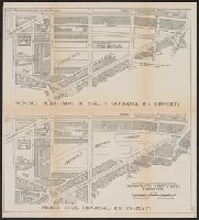
Present state, Providence R.R. property. and Proposed subdivision by streets, Providence R.R. property.
Description:
"Feb. 6, 1909.", Proposed subdivision by streets, Providence R.R. property -- Present state, Providence R.R. property., and Title supplied by cataloger.
Publisher:
Commonwealth of Massachusetts
Subject (Geographic):
Boston (Mass.)--Maps
Subject (Name):
Massachusetts . Metropolitan
Subject (Topic):
City planning--Massachusetts --Boston
Found in:
Beinecke Rare Book and Manuscript Library > [Boston, Mass., Providence R.R. property : proposed redevelopment] / Arthur A. Shurtleff.
Creator:
Published / Created:
1909
Call Number:
764 B65 1909B
Container / Volume:
BRBL_00456
Image Count:
1
Resource Type:
Maps, Atlases & Globes
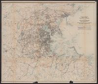
Description:
Relief shown by contours. and Thoroughfares overprinted on map derived from U.S.G.S. topographical maps.
Publisher:
Commonwealth of Massachusetts
Subject (Geographic):
Boston Region (Mass.)--Maps
Subject (Name):
Massachusetts . Metropolitan
Subject (Topic):
Highway planning--Massachusetts --Boston
Found in:
Beinecke Rare Book and Manuscript Library > Map of the existing and proposed circumferential thoroughfares of the district / Arthur A. Shurtleff.
Creator:
Published / Created:
[1909]
Call Number:
764 B65 1909G
Container / Volume:
BRBL_00456A
Image Count:
1
Resource Type:
Maps, Atlases & Globes
Alternative Title:
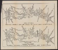
Existing streets between Allston and Somerville. and One of the possible connections between Allston and Somerville.
Description:
"Jan. 25, 1909.", One of the possible connections between Allston and Somerville -- Existing streets between Allston and Somerville., and Title supplied by cataloger.
Publisher:
Commonwealth of Massachusetts
Subject (Geographic):
Boston Metropolitan Area (Mass.)--Maps
Subject (Name):
Massachusetts . Metropolitan
Subject (Topic):
Highway planning--Massachusetts --Boston
Found in:
Beinecke Rare Book and Manuscript Library > [Boston, Mass., between Allston and Somerville : proposed redevelopment] / Arthur A. Shurtleff.
Creator:
Published / Created:
[1909]
Call Number:
764 B65 1909F
Container / Volume:
BRBL_00456A
Image Count:
1
Resource Type:
Maps, Atlases & Globes
Alternative Title:
Existing streets between the Harvard and Wellington Bridges. and One of the possible connections between the Harvard and Wellington Bridges.
Description:
"Jan. 28, 1909.", One of the possible connections between the Harvard and Wellington Bridges -- Existing streets between the Harvard and Wellington Bridges., and Title supplied by cataloger.
Publisher:
Commonwealth of Massachusetts
Subject (Geographic):
Boston Metropolitan Area (Mass.)--Maps
Subject (Name):
Massachusetts . Metropolitan
Subject (Topic):
Highway planning--Massachusetts --Boston
Found in:
Beinecke Rare Book and Manuscript Library > [Boston, Mass., streets between Harvard and Wellington Bridges : proposed redevelopment] / Arthur A. Shurtleff.
Creator:
Published / Created:
[1921]
Call Number:
764 1921
Container / Volume:
BRBL_00453
Image Count:
2
Resource Type:
Maps, Atlases & Globes
Alternative Title:
Standard map of Massachusetts
Description:
principal cities, list of Massachusetts
Publisher:
Rand McNally & Co.,
Subject (Geographic):
Massachusetts --Maps
Subject (Topic):
Railroads--Massachusetts --Maps
Found in:
Beinecke Rare Book and Manuscript Library > Rand McNally standard map of Massachusetts.
Branch:v1.61.6 ,Deployed:2024-06-12T09:55:33-04:00